Firuzkuh, Iran
| Firuzkuh فيروزكوه | |
|---|---|
| City | |
 Firuzkuh | |
| Coordinates: 35°45′25″N 52°46′26″E / 35.75694°N 52.77389°ECoordinates: 35°45′25″N 52°46′26″E / 35.75694°N 52.77389°E | |
| Country |
|
| Province | Tehran |
| County | Firuzkuh |
| Bakhsh | Central |
| Population (2016 Census) | |
| • Total | 17,453 [1] |
| Time zone | UTC+3:30 (IRST) |
| • Summer (DST) | UTC+4:30 (IRDT) |
| Website | Official website |
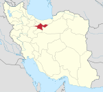
Firuzkuh (Persian: فيروزكوه, also Romanized as Fīrūzkūh and Fīrūz Kūh; Tabarian: Pirezcow; also known as Qaşabeh-ye Fīrūz Kūh)[2] is a city and capital of Firuzkuh County, Tehran Province, Iran. At the 2016 census, its population was 17,453.[3]
It is located north-east of Tehran, in the middle of Alborz Mountains. Previously, it was part of Mazandaran Province.
The city has a relatively cool and windy climate. It has some natural attractions and is famous for them, including Tange Vashi, Boornic Cave, Roodafshan Cave, Gardane Gadook and the sight-seeing of villages like Varse-Kharan, Zarrin Dasht, Darreh-Deh, and Kaveh Deh.
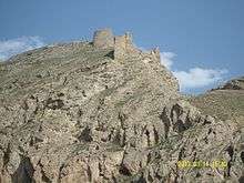
Firuzkuh is rich in historical heritage and some of the most ancient objects in Tehran Province have been found there. Among its villages Darreh-Deh contains the most ancient places. During the reign of Timur, Ruy González de Clavijo praised a nearby concentric citadel and suggested that it could resist any assault.[4] The castle belonged to the Nizari Ismaili state. Veresk Bridge lies on the road north from Firuzkuh.
| Climate data for Firuzkuh ( 1993-2005 ) | |||||||||||||
|---|---|---|---|---|---|---|---|---|---|---|---|---|---|
| Month | Jan | Feb | Mar | Apr | May | Jun | Jul | Aug | Sep | Oct | Nov | Dec | Year |
| Record high °C (°F) | 14.0 (57.2) |
15.4 (59.7) |
20.8 (69.4) |
26.6 (79.9) |
30.0 (86) |
33.4 (92.1) |
35.4 (95.7) |
35.6 (96.1) |
31.5 (88.7) |
26.0 (78.8) |
19.4 (66.9) |
17.0 (62.6) |
35.6 (96.1) |
| Average high °C (°F) | 2.5 (36.5) |
4.0 (39.2) |
9.7 (49.5) |
16.3 (61.3) |
21.2 (70.2) |
26.0 (78.8) |
28.4 (83.1) |
29.3 (84.7) |
25.2 (77.4) |
18.8 (65.8) |
10.8 (51.4) |
5.4 (41.7) |
16.5 (61.6) |
| Average low °C (°F) | −10.6 (12.9) |
−9.0 (15.8) |
−3.6 (25.5) |
1.5 (34.7) |
5.0 (41) |
9.0 (48.2) |
12.6 (54.7) |
12.0 (53.6) |
6.8 (44.2) |
1.7 (35.1) |
−2.5 (27.5) |
−7.0 (19.4) |
1.3 (34.4) |
| Record low °C (°F) | −26.6 (−15.9) |
−24.5 (−12.1) |
−16.0 (3.2) |
−13.0 (8.6) |
−2.5 (27.5) |
2.0 (35.6) |
5.0 (41) |
3.0 (37.4) |
−1.0 (30.2) |
−8.8 (16.2) |
−15.6 (3.9) |
−24.0 (−11.2) |
−26.6 (−15.9) |
| Average precipitation mm (inches) | 37.0 (1.457) |
29.4 (1.157) |
40.9 (1.61) |
36.9 (1.453) |
25.7 (1.012) |
9.4 (0.37) |
18.6 (0.732) |
10.4 (0.409) |
5.6 (0.22) |
14.8 (0.583) |
24.8 (0.976) |
28.9 (1.138) |
282.4 (11.117) |
| Average rainy days | 7.7 | 7.7 | 9.4 | 7.4 | 8.0 | 3.2 | 4.7 | 4.1 | 2.4 | 5.1 | 5.9 | 7.4 | 73 |
| Average snowy days | 4.6 | 5.1 | 3.4 | 1.2 | 0 | 0 | 0 | 0 | 0 | 0.1 | 1.4 | 4.2 | 20 |
| Average relative humidity (%) | 67 | 63 | 56 | 49 | 44 | 42 | 44 | 41 | 43 | 48 | 57 | 64 | 52 |
| Mean monthly sunshine hours | 181.4 | 194.2 | 223.3 | 240.0 | 300.9 | 340.5 | 330.6 | 325.0 | 301.7 | 251.3 | 196.8 | 170.7 | 3,056.4 |
| Source: [5] | |||||||||||||
References
- ↑ https://www.amar.org.ir/english
- ↑ Firuzkuh, Iran can be found at GEOnet Names Server, at this link, by opening the Advanced Search box, entering "-3063087" in the "Unique Feature Id" form, and clicking on "Search Database".
- ↑ Statistical Centre of Iran (web)
- ↑ Nicolle, David. The Age of Tamerlane. p. 22.
- ↑ I.R OF IRAN SHAHREKORD METEOROLOGICAL ORGANIZATION ( IN PERSIAN ).
| Capital | |||||||||||||||||||||||
|---|---|---|---|---|---|---|---|---|---|---|---|---|---|---|---|---|---|---|---|---|---|---|---|
| Districts |
| ||||||||||||||||||||||