Farmington, Washington
| Farmington | |
|---|---|
| Town | |
| Farmington, Washington | |
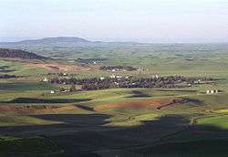 Farmington | |
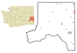 Location of Farmington, Washington | |
| Coordinates: 47°5′26″N 117°2′47″W / 47.09056°N 117.04639°WCoordinates: 47°5′26″N 117°2′47″W / 47.09056°N 117.04639°W | |
| Country | United States |
| State | Washington |
| County | Whitman |
| Area[1] | |
| • Total | 0.34 sq mi (0.88 km2) |
| • Land | 0.34 sq mi (0.88 km2) |
| • Water | 0 sq mi (0 km2) |
| Elevation | 2,641 ft (805 m) |
| Population (2010)[2] | |
| • Total | 146 |
| • Estimate (2015)[3] | 150 |
| • Density | 429.4/sq mi (165.8/km2) |
| Time zone | UTC-8 (Pacific (PST)) |
| • Summer (DST) | UTC-7 (PDT) |
| ZIP codes | 99104, 99128 |
| Area code | 509 |
| FIPS code | 53-23340 |
| GNIS feature ID | 1531452[4] |
Farmington is a town in Whitman County, Washington, United States. The population was 146 at the 2010 census.
History
Farmington was laid out in 1878.[5] Farmington was officially incorporated in 1888. At Farmington's peak (1900–1930) the town boasted a population of just under 500. As demand for farm labor decreased, the population and business of the town decreased. Today, Farmington has a population of about 150.
Geography
Farmington is located at 47°5′26″N 117°2′47″W / 47.09056°N 117.04639°W (47.090501, -117.046505).[6]
According to the United States Census Bureau, the town has a total area of 0.34 square miles (0.88 km2), all of it land.[1]
Demographics
| Historical population | |||
|---|---|---|---|
| Census | Pop. | %± | |
| 1880 | 76 | — | |
| 1890 | 418 | 450.0% | |
| 1900 | 434 | 3.8% | |
| 1910 | 489 | 12.7% | |
| 1920 | 479 | −2.0% | |
| 1930 | 344 | −28.2% | |
| 1940 | 341 | −0.9% | |
| 1950 | 239 | −29.9% | |
| 1960 | 176 | −26.4% | |
| 1970 | 140 | −20.5% | |
| 1980 | 176 | 25.7% | |
| 1990 | 126 | −28.4% | |
| 2000 | 153 | 21.4% | |
| 2010 | 146 | −4.6% | |
| Est. 2016 | 156 | [7] | 6.8% |
| U.S. Decennial Census[8] 2015 Estimate[3] | |||
2010 census
As of the census[2] of 2010, there were 146 people, 54 households, and 41 families residing in the town. The population density was 429.4 inhabitants per square mile (165.8/km2). There were 65 housing units at an average density of 191.2 per square mile (73.8/km2). The racial makeup of the town was 97.3% White and 2.7% Native American. Hispanic or Latino of any race were 2.1% of the population.
There were 54 households of which 35.2% had children under the age of 18 living with them, 66.7% were married couples living together, 7.4% had a female householder with no husband present, 1.9% had a male householder with no wife present, and 24.1% were non-families. 24.1% of all households were made up of individuals and 7.5% had someone living alone who was 65 years of age or older. The average household size was 2.70 and the average family size was 3.20.
The median age in the town was 42.3 years. 26% of residents were under the age of 18; 6.2% were between the ages of 18 and 24; 23.9% were from 25 to 44; 27.4% were from 45 to 64; and 16.4% were 65 years of age or older. The gender makeup of the town was 53.4% male and 46.6% female.
2000 census
As of the census of 2000, there were 153 people, 56 households, and 38 families residing in the town. The population density was 445.3 people per square mile (173.7/km²). There were 64 housing units at an average density of 186.3 per square mile (72.7/km²). The racial makeup of the town was 98.04% White, 1.31% Native American and 0.65% Asian. Hispanic or Latino of any race were 5.88% of the population.
There were 56 households out of which 37.5% had children under the age of 18 living with them, 55.4% were married couples living together, 8.9% had a female householder with no husband present, and 32.1% were non-families. 32.1% of all households were made up of individuals and 16.1% had someone living alone who was 65 years of age or older. The average household size was 2.73 and the average family size was 3.47.
In the town, the age distribution of the population shows 36.6% under the age of 18, 3.9% from 18 to 24, 20.9% from 25 to 44, 27.5% from 45 to 64, and 11.1% who were 65 years of age or older. The median age was 37 years. For every 100 females, there were 91.3 males. For every 100 females age 18 and over, there were 90.2 males.
The median income for a household in the town was $27,250, and the median income for a family was $39,063. Males had a median income of $41,875 versus $26,250 for females. The per capita income for the town was $13,099. About 8.0% of families and 7.9% of the population were below the poverty line, including none of those under the age of eighteen and 5.9% of those sixty five or over.
References
- 1 2 "US Gazetteer files 2010". United States Census Bureau. Archived from the original on 2012-01-24. Retrieved 2012-12-19.
- 1 2 "American FactFinder". United States Census Bureau. Retrieved 2012-12-19.
- 1 2 "Population Estimates". United States Census Bureau. Archived from the original on October 19, 2016. Retrieved July 9, 2016.
- ↑ "US Board on Geographic Names". United States Geological Survey. 2007-10-25. Retrieved 2008-01-31.
- ↑ Meany, Edmond S. Origin of Washington geographic names. Seattle: University of Washington Press. p. 83.
- ↑ "US Gazetteer files: 2010, 2000, and 1990". United States Census Bureau. 2011-02-12. Retrieved 2011-04-23.
- ↑ "Population and Housing Unit Estimates". Retrieved June 9, 2017.
- ↑ United States Census Bureau. "Census of Population and Housing". Archived from the original on May 12, 2015. Retrieved October 11, 2013.
External links
Municipalities and communities of Whitman County, Washington, United States | ||
|---|---|---|
| Cities | 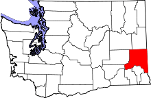 | |
| Towns | ||
| CDP | ||
| Other unincorporated communities | ||
| Ghost towns | ||