Falkenberg
| Falkenberg | ||
|---|---|---|
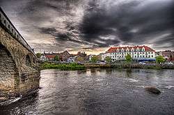 View from the Tullbron bridge in Falkenberg | ||
| ||
 Falkenberg  Falkenberg | ||
| Coordinates: 56°54′19″N 12°29′28″E / 56.90528°N 12.49111°ECoordinates: 56°54′19″N 12°29′28″E / 56.90528°N 12.49111°E | ||
| Country | Sweden | |
| Province | Halland | |
| County | Halland County | |
| Municipality | Falkenberg Municipality | |
| Founded | 1558 | |
| Area[1] | ||
| • Total | 14.85 km2 (5.73 sq mi) | |
| Elevation | 13 m (43 ft) | |
| Population (31 December 2010)[1] | ||
| • Total | 20,035 | |
| • Density | 1,349/km2 (3,490/sq mi) | |
| Time zone | UTC+1 (CET) | |
| • Summer (DST) | UTC+2 (CEST) | |
| Postal code | 311 xx | |
| Area code(s) | (+46) 34 | |
| Website | Official website | |

Falkenberg is a locality and the seat of Falkenberg Municipality, Halland County, Sweden, with 20,035 inhabitants in 2010[1] (out of a municipal total of 41,000). It is located at the mouth of river Ätran. The name consists of the Swedish words for falcon (falk) and mountain (berg). Falkenberg is a popular tourist destination in the summers, and the main beach of the town is Skrea strand.
History
In the early part of the 13th century the Danish king built a fort on the east shore of the river Ätran, which eventually would give the town its name. Halland was at that time part of Denmark. It is known that falconry was pursued in the area. However, in Hallandia antiqua et hodierna, that specified a location ("mountain") where the falconry should have taken place, and which should have given name to the town, has later been shown to be incorrect.
The area north of Ätran was from time to time Norwegian or Swedish. It was on this side that a market town developed. At around 1300 a church was built. From the 14th century until the Northern Seven Years' War (1563–1570) a second town, Ny-Falkenberg (New Falkenberg) was located close to the town. The fort was destroyed by Engelbrekt Engelbrektsson's troops in 1434. The town gained market rights at the latest in 1558.
Along with the rest of the Halland, Falkenberg was to be temporarily Swedish in accordance with the Treaty of Brömsebro (1645). The Treaty of Roskilde thirteen years later made the province permanently Swedish. For a long period it struggled to keep its privileges with regard to trade and jurisdiction from the Danish time. Also like the rest of the county, it only started to slowly industrialise in the late 19th century. In the 20th century it has gained a reputation as a seaside resort.
Communications
Falkenberg is located along a traditional trade route along the Swedish west coast, about 45 km (28 mi) northwest of Halmstad, and 105 km (65 mi) south of Gothenburg. These transport needs are currently catered by European route E6, which runs as a dual carriageway just outside the town, and the West Coast Railway Line. County road 150 and County road 154 connect to Torup and Svenljunga. Falkenberg railway operated from the 1890s to the 1950s. The town has seven bus routes.
Areas of the town
|
|
Sport
The town hosts several teams at national level. The football team, Falkenbergs FF, has since the late 1980s established itself in the second division (currently Superettan). The table tennis team, Falkenbergs BTK, has won ten national championships, as well as one European championship. In the early 2000s, Falkenbergs VBK developed to become one of the best volleyball teams in the country and accordingly won the national championship 2007. BK Falkarna has played ten seasons in the top bowling league.
Other sports clubs located in Falkenberg include:
- Skrea IF
- Arvidstorps IK
- Vinbergs IF
- Stafsinge IF
- Rinia IF
- IF Böljan
Sport venues in the town include Falkenbergs IP, hosting Falkenbergs FF, Falkenberg Sports Centre, hosting Falkenbergs VBK and Klitterbadet, a bath house.
Buildings
- Falkenberg Church
- Falkenberg Town Hall
- Falkenberg Old Town Hall
- Falkhallen
- Saint Lawrence church
People and groups from Falkenberg
- Ablaze My Sorrow, death metal band
- Annika Andersson, comedian
- Bo Andersson, Chief Operating Officer in biggest Russian car manufacturer AvtoVAZ
- Rutger Backe, footballer
- Stellan Bengtsson, table tennis player
- Nina Björk, author, journalist, feminist
- By Night, death metal/extreme metal band
- Ulf "Tickan" Carlsson, table tennis player
- Walter Dickson, author
- Leif Gustafsson, motorcycle racer
- Jojje Jönsson, actor
- Peter Karlsson, table tennis player
- Sonic Syndicate, melodic death metal/melodic metalcore band
- Erik "Spänst" Svensson, athlete
- Frida Svensson, rower
- Vains of Jenna, Lizzy DeVine, JP White, rock band
- Carl-Johan Vallgren, author
- Jan Widströmer, artist
- Pär Zetterberg, football player
- Hans Svensson (rower)
Sister cities
See also
References
- Hedén, Stig J., ed. (1995). Falkenberg - staden som hembygd. ISBN 91-630-3848-X.
- Eric Hägge (1966). Kommunalt sekel - Falkenbergs stadsfullmäktige 1866-1965. Lidköping: Landströms trycksaker AB.
- 1 2 3 "Tätorternas landareal, folkmängd och invånare per km2 2005 och 2010" (in Swedish). Statistics Sweden. 14 December 2011. Archived from the original on 10 January 2012. Retrieved 10 January 2012.
- ↑ "International collaboration". gmiezno.eu. Gniezno. Retrieved 3 May 2014.
External links
| Wikimedia Commons has media related to Falkenberg. |
Municipalities and seats of Halland County | ||
|---|---|---|
| Municipalities | ||
| Municipal seats | ||