Evanston Gardens, South Australia
| Evanston Gardens Adelaide, South Australia | |||||||||||||||
|---|---|---|---|---|---|---|---|---|---|---|---|---|---|---|---|
 Evanston Gardens | |||||||||||||||
| Coordinates | 34°37′26″S 138°43′19″E / 34.624°S 138.722°ECoordinates: 34°37′26″S 138°43′19″E / 34.624°S 138.722°E | ||||||||||||||
| Population |
770 (2006 census)[1] 787 (2001 Census)[2] | ||||||||||||||
| Postcode(s) | 5116[3] | ||||||||||||||
| Location | 35 km (22 mi) NE of Adelaide city centre[3] | ||||||||||||||
| LGA(s) | Town of Gawler | ||||||||||||||
| State electorate(s) | Light (2011)[4] | ||||||||||||||
| Federal Division(s) | Wakefield (2011)[5] | ||||||||||||||
| |||||||||||||||
Evanston Gardens is an outer northern suburb of Adelaide, South Australia. It is located in the Town of Gawler.
Geography
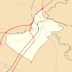
The suburb lies astride Angle Vale Road and is bounded on the east by the Sturt Highway (Gawler Bypass).[6]
Demographics
The 2006 Census by the Australian Bureau of Statistics counted 770 persons in Evanston Gardens on census night. Of these, 50.6% were male and 49.4% were female.[1]
The majority of residents (78.3%) are of Australian birth, with an additional 8.4% identifying England as their country of birth.[1]
The age distribution of Evanston Gardens residents is similar to that of the greater Australian population. 62.6% of residents were over 25 years in 2006, compared to the Australian average of 66.5%; and 37.4% were younger than 25 years, compared to the Australian average of 33.5%.[1]
Community
Local newspapers include the News Review Messenger and The Bunyip. Other regional and national newspapers such as The Plains Producer, The Advertiser and The Australian are also available.[7]
Schools
Evanston Gardens Primary School is located on Angle Vale Road.[8]
Facilities and attractions
Parks
Karbeethon Reserve lies on Angle Vale Road. There are parks elsewhere in the suburb, particularly on Hindmarsh Boulevard.[6]
Transportation
Roads
Evanston Gardens is serviced by Angle Vale Road, indirectly connecting the suburb to both Port Wakefield Road and the Sturt Highway.[6]
Public transport
Evanston Gardens is serviced by public transport run by the Adelaide Metro.[9]
Trains
The Gawler railway line passes through the suburb. The closest station is Tambelin.[9]
See also
References
- 1 2 3 4 Australian Bureau of Statistics (25 October 2007). "Evanston Gardens (State Suburb)". 2006 Census QuickStats. Retrieved 26 April 2011.
- ↑ Australian Bureau of Statistics (9 March 2006). "Evanston Gardens (State Suburb)". 2001 Census QuickStats. Retrieved 26 April 2011.
- 1 2 "Evanston Gardens, South Australia (Adelaide)". Postcodes-Australia. Postcodes-Australia.com. Retrieved 26 April 2011.
- ↑ "Electoral Districts - Electoral District for the 2010 Election". Electoral Commission SA. Archived from the original on 22 August 2011. Retrieved 26 April 2011.
- ↑ "Find my electorate". Australian Electoral Commission. 15 April 2011. Archived from the original on 30 April 2011. Retrieved 26 April 2011.
- 1 2 3 Adelaide and surrounds street directory (47th ed.). UBD. 2009. ISBN 978-0-7319-2336-6.
- ↑ "South Australian Newspapers". Newspapers.com.au. Australia G'day. Retrieved 26 April 2011.
- ↑ "Australian Schools Directory". Australian Schools Directory. Retrieved 26 April 2011.
- 1 2 "Public Transport in Adelaide". Adelaide Metro official website. Dept. for Transport, Energy and Infrastructure, Public Transport Division. 12 January 2011. Archived from the original on 26 April 2011. Retrieved 26 April 2011.
External links
- "Town of Gawler". Official website. Town of Gawler. Retrieved 26 April 2011.