Euclid, Minnesota
| Euclid, Minnesota | |
|---|---|
| Unincorporated community | |
 Euclid, Minnesota  Euclid, Minnesota | |
| Coordinates: 47°58′19″N 96°38′20″W / 47.97194°N 96.63889°WCoordinates: 47°58′19″N 96°38′20″W / 47.97194°N 96.63889°W | |
| Country | United States |
| State | Minnesota |
| County | Polk |
| Government | |
| • Mayor | Nicolas Schulz |
| Elevation | 896 ft (273 m) |
| Time zone | UTC-6 (Central (CST)) |
| • Summer (DST) | UTC-5 (CDT) |
| ZIP code | 56722 |
| Area code(s) | 218 |
| GNIS feature ID | 643426[1] |
Euclid is an unincorporated community in Polk County, Minnesota, United States. Euclid is located on U.S. Route 75 13.5 miles (21.7 km) north of Crookston. Euclid has a post office with ZIP code 56722.[2]
A post office called Euclid has been in operation since 1879.[3] The community was named after Euclid Avenue (Cleveland), a main boulevard of Cleveland, Ohio.[4]
| Historical population | |||
|---|---|---|---|
| Census | Pop. | %± | |
| 1880 | 67 | — | |
| U.S. Decennial Census[5] | |||
References
- ↑ "US Board on Geographic Names". United States Geological Survey. 2007-10-25. Retrieved 2008-01-31.
- ↑ ZIP Code Lookup
- ↑ "Polk County". Jim Forte Postal History. Archived from the original on 24 January 2016. Retrieved 31 July 2015.
- ↑ Upham, Warren (1920). Minnesota Geographic Names: Their Origin and Historic Significance. Minnesota Historical Society. p. 424.
- ↑ United States Census Bureau. "Census of Population and Housing".
Municipalities and communities of Polk County, Minnesota, United States | ||
|---|---|---|
| Cities | 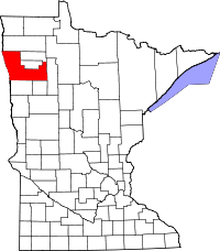 | |
| Townships |
| |
| Unincorporated communities | ||
| Indian reservation | ||
| Footnotes | ‡This populated place also has portions in an adjacent county or counties | |
This article is issued from
Wikipedia.
The text is licensed under Creative Commons - Attribution - Sharealike.
Additional terms may apply for the media files.