Dugdale, Minnesota
| Dugdale, Minnesota | |
|---|---|
| Unincorporated community | |
 Dugdale, Minnesota  Dugdale, Minnesota | |
| Coordinates: 47°42′06″N 96°15′59″W / 47.70167°N 96.26639°WCoordinates: 47°42′06″N 96°15′59″W / 47.70167°N 96.26639°W | |
| Country | United States |
| State | Minnesota |
| County | Polk |
| Elevation | 1,138 ft (347 m) |
| Time zone | UTC-6 (Central (CST)) |
| • Summer (DST) | UTC-5 (CDT) |
| Area code(s) | 218 |
| GNIS feature ID | 654680[1] |
Dugdale is an unincorporated community in Polk County, Minnesota, United States.[1] Dugdale is located at 47°42′06″N 96°15′59″W / 47.70167°N 96.26639°W.
The community is located east of Crookston and south of Red Lake Falls on Minnesota State Highway 32.
A post office called Dugdale was established in 1884, and remained in operation until 1927.[2] Dugdale had a depot on the railroad.[3]
References
- 1 2 U.S. Geological Survey Geographic Names Information System: Dugdale, Minnesota
- ↑ "Polk County". Jim Forte Postal History. Retrieved 31 July 2015.
- ↑ Upham, Warren (1920). Minnesota Geographic Names: Their Origin and Historic Significance. Minnesota Historical Society. p. 423.
Municipalities and communities of Polk County, Minnesota, United States | ||
|---|---|---|
| Cities | 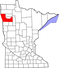 | |
| Townships |
| |
| Unincorporated communities | ||
| Indian reservation | ||
| Footnotes | ‡This populated place also has portions in an adjacent county or counties | |
This article is issued from
Wikipedia.
The text is licensed under Creative Commons - Attribution - Sharealike.
Additional terms may apply for the media files.