Ense
| Ense | ||
|---|---|---|
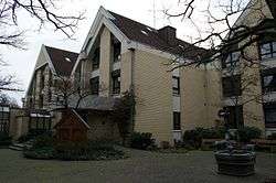 Townhall of Ense (in the town of Bremen (Ense)) | ||
| ||
 Ense Location of Ense within Soest district 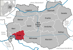  | ||
| Coordinates: 51°28′N 07°58′E / 51.467°N 7.967°ECoordinates: 51°28′N 07°58′E / 51.467°N 7.967°E | ||
| Country | Germany | |
| State | North Rhine-Westphalia | |
| Admin. region | Arnsberg | |
| District | Soest | |
| Government | ||
| • Mayor | Johannes Weber | |
| Area | ||
| • Total | 51.08 km2 (19.72 sq mi) | |
| Elevation | 206 m (676 ft) | |
| Population (2016-12-31)[1] | ||
| • Total | 12,321 | |
| • Density | 240/km2 (620/sq mi) | |
| Time zone | CET/CEST (UTC+1/+2) | |
| Postal codes | 59469 | |
| Dialling codes | 02938 | |
| Vehicle registration | SO | |
| Website | www.gemeinde-ense.de | |

Ense is a municipality in the district of Soest, in North Rhine-Westphalia, Germany.
Geography
Ense is situated on the river Möhne, approx. 12 km north-west of Arnsberg and 12 km south-west of Soest. Ense lies at the northside of the Sauerland and at the south side of the Haarstrang.
Neighbouring municipalities
Division of the town
Ense consists of the following 15 districts:
- Bilme (47 inhabitants)
- Bittingen (99 inhabitants)
- Bremen (Ense) (3.135 inhabitants)
- Gerlingen (66 inhabitants)
- Höingen (1.964 inhabitants)
- Hünningen (523 inhabitants)
- Lüttringen (990 inhabitants)
- Niederense (3.366 inhabitants)
- Oberense (276 inhabitants)
- Parsit (933 inhabitants)
- Ruhne (325 inhabitants)
- Sieveringen (352 inhabitants)
- Vierhausen
- Volbringen (137 inhabitants)
- Waltringen (671 inhabitants)
Twin towns


References
- ↑ "Amtliche Bevölkerungszahlen" (in German). Landesbetrieb Information und Technik NRW. Retrieved 2018-02-24.
External links
- Official website

| Wikimedia Commons has media related to Ense. |
Towns and municipalities in Soest (district) | ||
|---|---|---|
This article is issued from
Wikipedia.
The text is licensed under Creative Commons - Attribution - Sharealike.
Additional terms may apply for the media files.