Engandiyur
| Engandiyur Engandiyur | |
|---|---|
| Village | |
 Engandiyur Location in Kerala, India | |
| Coordinates: 10°30′N 76°02′E / 10.50°N 76.04°ECoordinates: 10°30′N 76°02′E / 10.50°N 76.04°E | |
| Country |
|
| State | Kerala |
| District | Thrissur |
| Tahsil | Chavakkad |
| Area | |
| • Total | 14.11 km2 (5.45 sq mi) |
| Elevation | 7.80 m (25.59 ft) |
| Population (2011) | |
| • Total | 23,101 |
| • Density | 827.93/km2 (2,144.3/sq mi) |
| Languages | |
| • Official | Malayalam |
| Time zone | UTC+5:30 (IST) |
| Telephone code | +91 |
| Nearest city | Chavakkad |
| Sex ratio | 1000:1194 ♂/♀ |
| Literacy | 85.85% |
| Climate | Average high (°C) (Köppen) |
Engandiyur is a village in the Chavakkad taluka of the Thrissur district in the state of Kerala, India.[1] It has an area of 1411 hectares and harbours 5760 households with total population of 23101 as per the 2011 Census. The nearest town Chavakkad is at a distance of 8 km. Male population is 10528 and female population is 12573. Scheduled Caste Population is 615 and Scheduled Tribes population is 45. Census Location Code of the village is 627789.[2]
Location
This village shares borders with Orumanayur Panchayath on the north side and Vadanapilly Panchayath on the south side. On the west side is the Arabian Sea and to the east, Canoli Canal. The native language of Engandiyoor is Malayalam and English.
Economy
Engandiyur is another village much dependent on Persian Gulf countries for income. TIPPU SULTHAN KOTTAThe famous Aayiram Kanni Temple, St. Thomas Church, Pokkulangara Temple, Thirumangalam Temple & St. Lourde Marys Church are located in this panchayat. The famous Elephant Shanmuka Priya Gaja Samrat Chulliparambil Vishnu Shankar ( Height: 305 cm) from this village, and there are also ten schools there; St. Thomas Higher Secondary School, St. Thomas LP School, National Higher Secondary School, Thriumangalm U P School, Paul Chitalapilly Memorial English Medium School, Thirunaarayana UP School, Technical Higher Secondary School, Chettuva and Sree Narayana UP School, and Saraswathy Vidya Nikethan Central School. File:azhimugam.jpeg|thumb|chettua azhimugham
Engandiyur is well developed in Education, Literacy, Health, Employment and Shelter. Engandiyur won the Swaraj Trophy award for Best Panchayat in Thrissur district twice consecutively (2012-2013 & 2013-2014).[3]
Demographics
As of 2001 India census, Engandiyur had a population of 22,449 with 10,232 males and 12,217 females.[1]
Literacy
- Total literate population: 19832 (85.85%)
- Literate male population: 9034 (85.81%)
- Literate female population: 10798 (85.88%)
Educational Facilities
There is 1 private Pre-primary School in the village. There are 7 government Primary Schools in the village.There is 1 private Primary School in the village. There are 4 government Middle Schools in the village.There are 2 private Middle Schools in the village. There are 2 government Secondary Schools in the village.There is 1 private Secondary School in the village. There are 3 government Senior Secondary Schools in the village. The nearest Degree College of Arts and Science and Commerce (Nattika) is at a distance of 5 to 10 km from the village. The nearest Engineering College (Thrissur) is at a distance of more than 10 km from the village. The nearest Medical College (Velappaya) is at a distance of more than 10 km from the village. The nearest Management Institute (Thrissur) is at a distance of more than 10 km from the village. The nearest Polytechnic (Nattika) is at a distance of 5 to 10 km from the village. The nearest Vocational Training School (Thrissur) is at a distance of more than 10 km from the village. The nearest Non-formal Training Centre (Thrissur) is at a distance of more than 10 km from the village. The nearest Special School for Disabled (Thrissur) is at a distance of more than 10 km from the village. The nearest other educational facilities (Thrissur) is at a distance of more than 10 km from the village.
Medical Facilities
Hospitals
- Mary Immaculate Hospital,
- M.E.S Hospital
- Well care Hospital
Government
The nearest community health centre is at a distance of less than 5 km from the village. There is one primary health centre in the village. There is one primary health sub centre in the village. There is one maternity and child welfare centre in the village. The nearest T.B. clinic is at a distance of more than 10 km from the village. The nearest allopathy hospital is at a distance of 5 to 10 km from the village. The nearest alternative medicine hospital is at a distance of 5 to 10 km from the village. There are three dispensaries in the village. There is one veterinary hospital in the village. The nearest mobile health clinic is at a distance of more than 10 km from the village. There is one family welfare centre in the village.
Non-Government
There are 6 Out Patient medical facility s in the village. There are 6 In and Out Patient medical facility s in the village. There are 2 Charitable non Govt. hospital/Nursing homes in the village. There are 6 Medical practitioner(s) with MBBS Degrees in the village. There is 1 Traditional practitioner(s) and faith healer in the village. There are 7 Medicine Shops in the village.
Transportation
The nearest airport is Cochin International Airport, Kochi - 65 km distant. The nearest railway stations are at Thrissur (28 km) and Guruvayoor (8 km). NH-17 passes middle through the village and also two parallel roads named east and west Tippu Sulthan roads are there. Also a mini harbour located at north west of the village mainly used for fishing.
Auto/Modified Auto is available in the village. Public bus service is available in the village. Private bus service is available in the village.
Communication
Post office is available in the village. Village pin code is 680615 in the village.Telephones (Land lines) is available in the village. Public call office is available in the village. Mobile phone coverage is available in the village. Internet cafes / Common service centre is not available in the village; the nearest Internet cafes / Common service centre is at a distance of less than 5 km from the village. Private courier is not available in the village; the nearest Private courier is at a distance of less than 5 km from the village.
Taxi is available in the village. Tractor is not available in the village. Village is connected to a national highway Village is not connected to astate highway The nearest state highway is at a distance of less than 5 km from the village. Village is connected to amajor district road Village is connected to another district road
Drinking Water
Water from treated tap water is available in the village. Water from untreated tap water is available in the village. Water from covered wells is not available in the village. Water from uncovered wells is available in the village. Water from Hand pumps is available in the village. Water from Tube wells / Bore wells is available in the village. Water from Springs is not available in the village. Water from River / Canal is available in the village. Water from Tank / Pond / Lake is available in the village.
Economy
The main source of economy is foreign money from the persons who are working in gulf countries,fishing and farming are another major source of economy.People earn money by selling shells, crab, fish,etc..
Sanitation
Closed Drainage is not available in the village. Open Drainage is available in the village. Drain water is discharged directly into sewer plant. Area is covered under Total Sanitation Campaign (TSC). Community toilet including bath is not available in the village. Community toilet excluding bath is not available in the village.
Market and Banking
ATM is available in the village. Commercial Bank is available in the village. Co-operative Bank is available in the village. Agricultural Credit Society is available in the village. Self-Help Group is available in the village. Public distribution system (PDS) shop is available in the village. Weekly Haat is not available in the village.The nearest Weekly Haat is at a distance of 5 to 10 km from the village. Agricultural marketing society is not available in the village.The nearest Agricultural marketing society is at a distance of 5 to 10 km from the village.
Health & Nutrition & Entertainment Amenities
Integrated Child Development Scheme (Nutritional Centre) is not available in the village.The nearest Integrated Child Development Scheme (Nutritional Centre) is at a distance of 5 to 10 km from the village. Anganwadi Centre (Nutritional Centre) is available in the village. Others (Nutritional Centre) is not available in the village.The nearest Others (Nutritional Centre) is at a distance of 5 to 10 km from the village. ASHA (Accredited Social Health Activist is available in the village. Sports Field is available in the village. Cinema / Video Hall is available in the village. Public Library is available in the village. Public Reading Room is available in the village. Newspaper Supply is available in the village. Assembly Polling station is available in the village. Birth & Death Registration Office is available in the village.
Electricity
In summer (Apr-Sep) electricity is available for 23 hours per day and in winter (Oct-Mar) for 24 hours per day.
Land Use
Engandiyur exhibits the following land use pattern (area in hectares):
- Forest: 0
- Area under Non-agricultural Uses: 157.13
- Barren and Un-cultivable land: 0
- Permanent Pastures and Other Grazing Lands: 0
- Land Under Miscellaneous Tree Crops, etc.: 0
- Culturable Waste Land: 0
- Fallow lands other than current fallows: 0
- Current Fallows: 0
- Net Area Sown: 1253.87
- Total Un-irrigated Land Area: 1049.66
- Area irrigated by source: 204.21
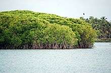
Ecology
East side of the village covered by canoly canal and west side by Arabian sea. Estuaries are the most big treasure of this village. Presence of Mangrove vegetation was also home to many organisms.
Salt Water Intrusion
Salt water intrusion is the main issue in this area. Salt water will enter into the farming lands and household water resources in summer season. Proper maintaining of Meenkadav Bund, Enamakkal bund, which are the main check dam of the village may reduce this problem.
Irrigation facilities
Sources of irrigation are as follows (area in hectares):
- Canals: 0
- Wells/Tube-wells: 83.77
- Tanks/Lakes: 0
- Water Falls: 0
- Others: 120.44
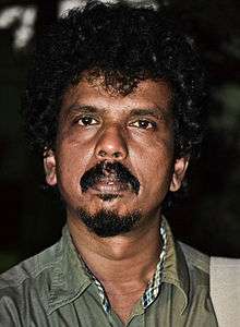
Notable people
This village is well known by its vast literal and cultural features. Many personalities include:
- Ramu Kariat, famous film director, who was noted for National Award winning movie Chemmeen
- Velayudhan Panikkassery, famous historian/writer
- Engandiyur Chandrasekharan, leading lyricist and poet in new era of Malayalam film industry
Others include V S Keraleeyan, notable freedom fighter. Malayala Maharshi also belongs to this village
Bro.V.K.Velukutty Master is the person who started night study classes and literacy programme in this panchayath. He is the first man who brought bicycle to this village.
References
- 1 2 "Census of India: Villages with population 5000 & above". Registrar General & Census Commissioner, India. Archived from the original on 2008-12-08. Retrieved 2008-12-10.
- ↑ http://www.censusindia.gov.in/2011census/dchb/DCHB.html
- ↑ http://lsg.kerala.gov.in/en/SwarajTrophy_en.php
External links
- www.engandiyur.com - A website all about Engandiyur Village/Panchayath