Elwood, Kansas
| Elwood, Kansas | |
|---|---|
| City | |
 Location within Doniphan County and Kansas | |
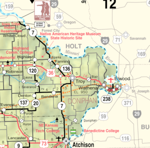 KDOT map of Doniphan County (legend) | |
| Coordinates: 39°45′13″N 94°52′42″W / 39.75361°N 94.87833°WCoordinates: 39°45′13″N 94°52′42″W / 39.75361°N 94.87833°W | |
| Country | United States |
| State | Kansas |
| County | Doniphan |
| Area[1] | |
| • Total | 3.20 sq mi (8.29 km2) |
| • Land | 3.20 sq mi (8.29 km2) |
| • Water | 0 sq mi (0 km2) |
| Elevation | 801 ft (244 m) |
| Population (2010)[2] | |
| • Total | 1,224 |
| • Estimate (2016)[3] | 1,164 |
| • Density | 380/sq mi (150/km2) |
| Time zone | UTC-6 (Central (CST)) |
| • Summer (DST) | UTC-5 (CDT) |
| ZIP code | 66024 |
| Area code(s) | 913 |
| FIPS code | 20-20950[4] |
| GNIS feature ID | 0473054[5] |
Elwood is a city in Doniphan County, Kansas, United States, located across the Missouri River from Saint Joseph. As of the 2010 census, the city population was 1,224.[6]
History
A trading post was established at Elwood in 1852.[7] In 1856, the site was sold and the town was then laid out. The town was named for John B. Elwood, a pioneer settler.[8] Elwood was incorporated as a city in 1860.[7]
The first post office in Elwood was established in June, 1857.[9]
Geography
Elwood is located at 39°45′13″N 94°52′42″W / 39.75361°N 94.87833°W (39.753544, -94.878345).[10] According to the United States Census Bureau, the city has a total area of 3.20 square miles (8.29 km2), all land.[1]
Demographics
| Historical population | |||
|---|---|---|---|
| Census | Pop. | %± | |
| 1880 | 323 | — | |
| 1890 | 377 | 16.7% | |
| 1900 | 623 | 65.3% | |
| 1910 | 636 | 2.1% | |
| 1920 | 750 | 17.9% | |
| 1930 | 849 | 13.2% | |
| 1940 | 1,014 | 19.4% | |
| 1950 | 1,020 | 0.6% | |
| 1960 | 1,191 | 16.8% | |
| 1970 | 1,283 | 7.7% | |
| 1980 | 1,275 | −0.6% | |
| 1990 | 1,079 | −15.4% | |
| 2000 | 1,145 | 6.1% | |
| 2010 | 1,224 | 6.9% | |
| Est. 2016 | 1,164 | [3] | −4.9% |
| U.S. Decennial Census | |||
Elwood is part of the St. Joseph, MO–KS Metropolitan Statistical Area.
2010 census
As of the census[2] of 2010, there were 1,224 people, 498 households, and 331 families residing in the city. The population density was 382.5 inhabitants per square mile (147.7/km2). There were 533 housing units at an average density of 166.6 per square mile (64.3/km2). The racial makeup of the city was 87.1% White, 6.7% African American, 0.9% Native American, 0.2% Asian, 1.0% from other races, and 4.2% from two or more races. Hispanic or Latino of any race were 4.4% of the population.
There were 498 households of which 32.3% had children under the age of 18 living with them, 46.4% were married couples living together, 15.1% had a female householder with no husband present, 5.0% had a male householder with no wife present, and 33.5% were non-families. 28.9% of all households were made up of individuals and 10% had someone living alone who was 65 years of age or older. The average household size was 2.46 and the average family size was 3.00.
The median age in the city was 36.7 years. 25.1% of residents were under the age of 18; 10.3% were between the ages of 18 and 24; 24.6% were from 25 to 44; 27.2% were from 45 to 64; and 12.9% were 65 years of age or older. The gender makeup of the city was 50.1% male and 49.9% female.
2000 census
As of the census[4] of 2000, there were 1,145 people, 446 households, and 313 families residing in the city. The population density was 562.9 people per square mile (217.8/km²). There were 494 housing units at an average density of 242.9 per square mile (94.0/km²). The racial makeup of the city was 89.08% White, 6.64% African American, 0.26% Native American, 0.44% Asian, 0.35% from other races, and 3.23% from two or more races. Hispanic or Latino of any race were 1.48% of the population.
There were 446 households out of which 37.9% had children under the age of 18 living with them, 49.3% were married couples living together, 15.9% had a female householder with no husband present, and 29.8% were non-families. 25.8% of all households were made up of individuals and 10.8% had someone living alone who was 65 years of age or older. The average household size was 2.57 and the average family size was 3.07.
In the city, the population was spread out with 30.9% under the age of 18, 10.2% from 18 to 24, 27.0% from 25 to 44, 20.7% from 45 to 64, and 11.2% who were 65 years of age or older. The median age was 32 years. For every 100 females, there were 98.4 males. For every 100 females age 18 and over, there were 88.8 males.
The median income for a household in the city was $28,950, and the median income for a family was $31,136. Males had a median income of $26,103 versus $17,692 for females. The per capita income for the city was $12,601. About 16.3% of families and 17.0% of the population were below the poverty line, including 21.1% of those under age 18 and 17.9% of those age 65 or over.
Education
Elwood is served by USD 114 Riverside. School unification consolidated Elwood schools and Wathena schools forming USD 114. The Riverside High School mascot is Cyclones.[11]
Elwood High School closed through school unification. The Elwood High School mascot was Elwood Panthers.[12]
References
- 1 2 "US Gazetteer files 2010". United States Census Bureau. Archived from the original on 2012-01-24. Retrieved 2012-07-06.
- 1 2 "American FactFinder". United States Census Bureau. Retrieved 2012-07-06.
- 1 2 "Population and Housing Unit Estimates". Retrieved June 9, 2017.
- 1 2 "American FactFinder". United States Census Bureau. Archived from the original on 2013-09-11. Retrieved 2008-01-31.
- ↑ "US Board on Geographic Names". United States Geological Survey. 2007-10-25. Retrieved 2008-01-31.
- ↑ "2010 City Population and Housing Occupancy Status". U.S. Census Bureau. Archived from the original on July 21, 2011. Retrieved August 11, 2011.
- 1 2 Blackmar, Frank Wilson (1912). Kansas: A Cyclopedia of State History, Embracing Events, Institutions, Industries, Counties, Cities, Towns, Prominent Persons, Etc. Standard Publishing Company. p. 585.
- ↑ "Profile for Elwood, Kansas". ePodunk. Retrieved 8 June 2014.
- ↑ "Kansas Post Offices, 1828-1961 (archived)". Kansas Historical Society. Archived from the original on October 9, 2013. Retrieved 8 June 2014.
- ↑ "US Gazetteer files: 2010, 2000, and 1990". United States Census Bureau. 2011-02-12. Retrieved 2011-04-23.
- ↑ "Riverside High School". USD 114. Retrieved 3 January 2017.
- ↑ "Elwood High School Panthers Alumni - Elwood Kansas KS". AlumniClass.com Inc. Retrieved 3 January 2017.
External links
| Wikimedia Commons has media related to Elwood, Kansas. |
- City
- Schools
- USD 114, local school district
- Maps
- Elwood City Map, KDOT
Municipalities and communities of Doniphan County, Kansas, United States | ||
|---|---|---|
| Cities | 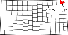 | |
| CDP | ||
| Unincorporated communities | ||
| Ghost town | ||
| Indian reservation | ||
| Townships | ||
| Footnotes | ‡This populated place also has portions in an adjacent county or counties | |