Ellis, Wisconsin
| Ellis, Wisconsin | |
|---|---|
| Unincorporated community | |
 Ellis, Wisconsin  Ellis, Wisconsin | |
| Coordinates: 44°34′30.7″N 89°26′47.9″W / 44.575194°N 89.446639°WCoordinates: 44°34′30.7″N 89°26′47.9″W / 44.575194°N 89.446639°W | |
| Country | United States |
| State | Wisconsin |
| County | Portage |
| Elevation | 1,171 ft (357 m) |
| Time zone | UTC-6 (Central (CST)) |
| • Summer (DST) | UTC-5 (CDT) |
| Area code(s) | 715 and 534 |
| GNIS feature ID | 1564540[1] |
Ellis is an unincorporated community in the town of Sharon, Portage County, Wisconsin, United States.[1][2]
History
Originally known as Poland Corners, Ellis was renamed in 1867 when the post office was established. It was named in honor of Albert G. Ellis, who was the mayor of Stevens Point, Wisconsin at the time.[3]
Geography

Ellis is located in central Wisconsin approximately six miles northeast of Stevens Point, approximately four miles north of Custer, and approximately six miles southwest of Rosholt, where State Road 66 and Portage County Road J to the south meets with Ellis Road. Ellis is located on State Road 66 between Portage County Road K to the north and K to the south in Polonia.
Notes
- 1 2 "Ellis, Wisconsin". Geographic Names Information System. United States Geological Survey.
- ↑ Ellis, Wisconsin
- ↑ Callary, Edward. Place Names of Wisconsin. Madison, WI: University of Wisconsin Press. p. 87. ISBN 978-0-299-30964-0.
External links
- History of Ellis from the Portage County Historical Society
Municipalities and communities of Portage County, Wisconsin, United States | ||
|---|---|---|
| City | 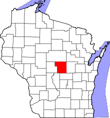 | |
| Villages | ||
| Towns | ||
| CDPs | ||
| Unincorporated communities | ||
| Ghost town/neighborhood | ||
| Footnotes | ‡This populated place also has portions in an adjacent county or counties | |
This article is issued from
Wikipedia.
The text is licensed under Creative Commons - Attribution - Sharealike.
Additional terms may apply for the media files.