Elkhorn Creek (Kentucky)
| Elkhorn Creek | |
|---|---|
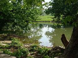 North Elkhorn Creek in Georgetown, Kentucky. | |
| Physical characteristics | |
| Main source |
Confluence of North and South forks in Franklin County 650 ft (200 m)[1] |
| River mouth |
Kentucky River in Franklin County 456 ft (139 m)[2] |
| Basin features | |
| Basin size | 499.5 square miles (1,294 km2) |
Elkhorn Creek is an 18.3-mile-long (29.5 km)[3] stream running through several counties in central Kentucky in the United States. The stream drains an area of 499.5 square miles (1,294 km2).[4] It derives its name from the shape, as seen on a map, of its main stem with its two primary forks.

North Elkhorn Creek starts just east of Lexington and flows 75.4 miles (121.3 km)[3] through Fayette and Scott counties, and into Franklin County, where it meets the South Elkhorn at the Forks of the Elkhorn east of Frankfort. South Elkhorn Creek begins in Fayette County, and flows 52.8 miles (85.0 km)[3] through Woodford, Scott and Franklin counties to reach the Forks of the Elkhorn. South Elkhorn Creek defines the boundary between Scott and Woodford counties. Beyond the Forks of the Elkhorn, the confluent waters flow north and empty into the Kentucky River north of Frankfort.
Species of fish in the Elkhorn include catfish, rock bass, smallmouth bass, largemouth bass, carp, crappie, and bluegill. Smallmouth bass is the featured fish of Elkhorn, as Elkhorn has been known to have a healthy population of this species.
Fishing tips can be accessed from the Kentucky Department of Fish and Wildlife Resources website.
Elkhorn is popular for being a kayaking/canoeing spot for many outdoor adventurers. Elkhorn is a popular destination for not only Kentuckians, but also many visitors from out of state also.
Elkhorn Creek is mentioned in the poem "Song of Myself" by Walt Whitman:
A Southerner soon as a Northerner, a planter nonchalant and hospitable down by the Oconee I live, A Yankee bound my own way ready for trade, my joints the limberest joints on earth and the sternest joints on earth, A Kentuckian walking the vale of the Elkhorn in my deer-skin leggings, a Louisianan or Georgian...
See also
References
- ↑ U.S. Geological Survey Geographic Names Information System: North Elkhorn Creek
- ↑ U.S. Geological Survey Geographic Names Information System: Elkhorn Creek (Kentucky)
- 1 2 3 U.S. Geological Survey. National Hydrography Dataset high-resolution flowline data. The National Map Archived 2012-04-05 at WebCite, accessed June 13, 2011
- ↑ U.S. Geological Survey. National Hydrography Dataset, area data covering Elkhorn Creek watershed, 10-digit Hydrologic Unit Codes 0510020508 and 0510020509. The National Map Archived 2012-04-05 at WebCite, retrieved 2015-10-27
Coordinates: 38°19′03″N 84°51′20″W / 38.3175704°N 84.8555053°W [1]