Elegu
| Elegu | |
|---|---|
 Elegu Location on the South Sudan–Uganda border Placement on map is approximate | |
| Coordinates: 03°33′59″N 32°04′14″E / 3.56639°N 32.07056°ECoordinates: 03°33′59″N 32°04′14″E / 3.56639°N 32.07056°E | |
| Country |
|
| Region | Northern Region of Uganda |
| Sub-region | Acholi sub-region |
| District | Amuru District |
| Elevation | 1,200 m (3,900 ft) |
| Population (2012 Estimate) | |
| • Total | 5,000[1] |
Elegu is a town in the Northern Region of Uganda. It sits across the international border from the town of Nimule, South Sudan.[2]
Location
The town is in Amuru District, Acholi sub-region, at the international border with South Sudan, approximately 100 kilometres (62 mi), by road, north of Gulu, the largest city in the sub-region.[3] Elegu is about 434 kilometres (270 mi), north of Kampala, Uganda's capital and largest city.[4] The coordinates of the town are 3°33'59.0"N, 32°04'14.0"E (Latitude:3.566389; Longitude:32.070556)[5]
Overview
Elegu was established in 2012. It sits across the Uganda-South Sudan border from the much larger city of Nimule.[6] Before 2012, the customs and immigration functions on the Ugandan side were done in Bibia,[1] 3.5 kilometres (2 mi),[7] to the south, along the Gulu–Nimule Road. The border crossing is in the process of being converted to a "One Stop Border Point". Construction is expected to be completed by December 2016 at a budgeted cost of US$7.1 million.[8]
Population
In 2012, the population of Elegu was estimated at 5,000 people.[1]
Points of interest
- offices of Elegu Town Council
- Elegu central market
- offices of the Uganda Revenue Authority
- offices of the Uganda Immigration Department
- Nimule National Park, to the east and north of the town.
One stop border post
Using US$4 million funding sources from Trademark East Africa, the border crossing on the South Sudan side is under improvement to a one-stop border crossing, as of May 2018. At that time, work on the Elegu (Uganda) side had been completed, but was awaiting completion of the work on the Nimule (South Sudan) side, in order to become functional.[9] The funds will be used to construct a customs and immigration building, a parking yard, examination shed, access roads and drainage channels.[10]
See also
References
- 1 2 3 Bagala, Andrew (22 July 2012). "Elegu: A Booming Town Clamouring for Services". Daily Monitor. Kampala. Retrieved 23 July 2015.
- ↑ Ojok, Michael (21 April 2018). "South Sudan-Uganda border point, Elegu, is prone to floods. Solutions are near". Juba: CrossBordernet.org.
- ↑ GFC (23 July 2015). "Road Distance Between Gulu And Elegu With Route Marker". Globefeed.com (GFC). Retrieved 23 July 2015.
- ↑ GFC (23 July 2015). "Map Showing Kampala And Elegu With Route Marker". Globefeed.com (GFC). Retrieved 23 July 2015.
- ↑ Google (23 July 2015). "Location of Elegu at Google Maps" (Map). Google Maps. Google. Retrieved 23 July 2015.
- ↑ IRIN (11 June 2007). "SUDAN: Boomtown Nimule under strain". IRIN News. Retrieved 23 July 2015.
- ↑ GFC (23 July 2015). "Map Showing Bibia And Elegu With Route Marker". Globefeed.com (GFC). Retrieved 23 July 2015.
- ↑ TMEA (2012). "Elegu OSBP Construction". Trademark East Africa (TMEA). Retrieved 23 July 2015.
- ↑ Nandudu, Prossy (28 May 2018). "Elegu one-stop centre to reduce clearing time". New Vision. Kampala. Retrieved 28 May 2018.
- ↑ Ismail Musa Ladu (1 June 2018). "Shs14.9 billion to improve Uganda, South Sudan trade". Daily Monitor. Kampala. Retrieved 1 June 2018.
External links
- Planned Infrastructure Projects Between Uganda And South Sudan
- Revenue Slumps At Uganda-South Sudan Border
- Draft Report On Border Procedures (78 Pages) As of December 2011.
Capital: Amuru | ||
| Towns and villages | 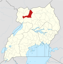 | |
| Geography |
| |
| Economy | ||
| Transport | ||
| Notable people | ||