Electoral district of Emerald Hill
| Emerald Hill Victoria—Legislative Assembly | |
|---|---|
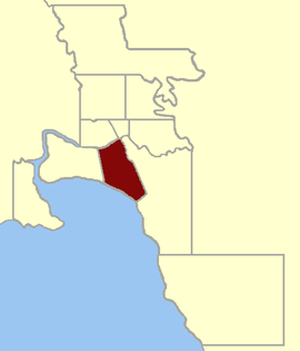 Location within Greater Melbourne area, 1859 | |
| State | Victoria |
| Created | 1859 |
| Abolished | 1904 |
| Demographic | Inner Metropolitan |
| Coordinates | 37°50′S 144°58′E / 37.833°S 144.967°ECoordinates: 37°50′S 144°58′E / 37.833°S 144.967°E |
Emerald Hill was an electoral district of the Victorian Legislative Assembly, Australia. It covered part of the inner-city suburb South Melbourne and consisted part of the previous Electoral district of South Melbourne which was abolished in 1859. (The other part of the South Melbourne electorate became the Electoral district of Sandridge).
1859
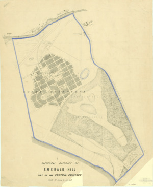
Emerald Hill was first proclaimed in 1859,[1] and was defined in the Victorian Electoral Act, 1858 (which took effect at the 1859 elections) as:
| “ | Commencing at a point on the south bank of the River Yarra, due south from the Gas Works;[g] thence by a line south-easterly to a point on the shores of Hobson's Bay, twenty chains more or less westward of the Battery ; thence by the sea coast to Fitzroy-street, St. Kilda; thence by that street and the Main Brighton Road to Prince's Bridge; and thence by the River Yarra to the commencing point.[2] | ” |
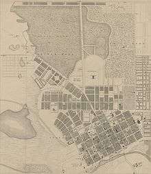
g This point is approximately where Wurundjeri Way crosses the south bank of the river now.[3]
1889
Emerald Hill was redefined as a single-member electorate by the Electoral Act Amendment Act 1888 (which took effect at the 1889 elections) as:
| “ | Commencing at the intersection of Pickles and Cowie streets ; thence south-easterly by Cowie-street to Bridport-street; east by Bridport-street to Cecil-street ; north by Cecil-street to the St. Kilda Railway ; further north crossing the St. Kilda and Sandridge Railways and by Cecil-street extension to the Normanby-road ; easterly crossing that road to White-street ; north-westerly by White-street to the River Yarra ; down that river to a point opposite the south-west angle of the City of Melbourne; thence to and by Boundary-street to Pickles-street ; by Pickles-street to the commencing point.[4] | ” |
That part of the pre-1888 district immediately south of the Yarra became the Electoral district of Melbourne South.[4]
Parts of the electorate were later amalgamated into the Electoral district of Albert Park.[5]
Members for Emerald Hill
| Member 1 | Party | Term | |||||
|---|---|---|---|---|---|---|---|
| Robert Stirling Hore Anderson | Oct 1859 – Aug 1864 | ||||||
| Henry Creswick | Nov 1864 – Dec 1865 | ||||||
| John Whiteman | Feb 1866 – Dec 1867 | ||||||
| George Frederic Verdon | Mar 1868 – May 1868 | 2 Members (1877–1889) | |||||
| John Whiteman | Jun 1868 – Apr 1877 | Member 2 | Party | Term | |||
| Andrew Lyell | Ministerial[6] | May 1877 – Jun 1880 | John Nimmo | Liberal | May 1877 – Mar 1889 | ||
| Robert MacGregor | Jul 1880 – Sep 1883 | ||||||
| David Gaunson | Oct 1883 – Mar 1889 | ||||||
| Thomas Smith | Labor | Apr 1889 – May 1904 | |||||
References
- ↑ "Re-member (former members)". Parliament of Victoria. Retrieved 8 January 2013.
- ↑ "An Act to alter the Electoral Districts of Victoria and to increase the number of Members of the Legislative Assembly thereof" (PDF). 1858. Retrieved 24 April 2013.
- ↑ The Gas Works are shown on this 1855 map of Melbourne (at right).
- 1 2 "The Electoral Act Amendment Act 1888" (pdf). Retrieved 12 June 2013.
- ↑ "Electoral Districts Boundaries Act 1903". Australasian Legal Information Institute. Retrieved 21 January 2014.
- ↑ "The New Parliament". The Camperdown Chronicle. 15 May 1877. Retrieved 8 January 2013.