Ebor, New South Wales
| Ebor New South Wales | |||||||||
|---|---|---|---|---|---|---|---|---|---|
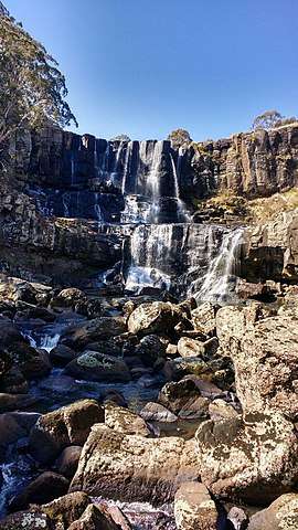 Upper Falls, Ebor | |||||||||
 Ebor | |||||||||
| Coordinates | 30°24′S 152°21′E / 30.400°S 152.350°ECoordinates: 30°24′S 152°21′E / 30.400°S 152.350°E | ||||||||
| Population | 166 (2016 census)[1] | ||||||||
| Postcode(s) | 2453 | ||||||||
| Elevation | 1,350 m (4,429 ft) | ||||||||
| Location | |||||||||
| LGA(s) | Armidale Regional Council | ||||||||
| County | Clarke | ||||||||
| State electorate(s) | Northern Tablelands | ||||||||
| Federal Division(s) | New England | ||||||||
| |||||||||
Ebor is a village on Waterfall Way on the Northern Tablelands in New South Wales, Australia. It is situated about 80 km (50 mi) east of Armidale and about a third of the way between Armidale and the coast. Dorrigo to the east is 46 kilometres (29 mi) away with the Coffs Coast 55 kilometres (34 mi) beyond along the Waterfall Way.
In the 2016 census, Ebor had a population of 166.[1]
Facilities
- a cafe [3]
- a combined post office, fuel station and shop (fuel available 24/7) [4]
- a pub/motel with camp ground [5]
- a NSW DEC primary school[6]
- Rural Fire Service depot
- National Parks and Wildlife Service depot[7]
- sports ground (home of the Ebor Campdraft[8])
- a tourist information board is located near the Ebor Public School
- public toilets with disabled access at both the Ebor upper and lower falls car parks/ picnic areas.
- public toilets (flushing) with disabled access at the free overnight camping area about 100 metres (330 ft) beyond the falls road
Features
In 1930 Sydney Smith Jr. made an observation that remains true today, "During a recent visit to Ebor I was much impressed with the possibilities of this part of the State as a tourist resort... Around Ebor and Guy Fawkes can be seen some of the most magnificent scenery in this State if not Australia. ...The two falls are scenes of beauty, and in winter time are sometimes frozen, making a beautiful spectacle as they hang in huge icicles. The water from the Ebor eventually finds an outlet in the Clarence River. ...The view, ...as regards expansiveness, ruggedness, and beauty, must compare more than favourably with views of a similar nature in any part of the Commonwealth. It reminded me of the Valley of a Thousand Hills, outside Durban, in South Africa."[9]
The surrounding district is indeed rich in natural beauty[10], although many areas have been degraded by clearing for pastoralism and forestry[11]. Nonetheless, the national parks around Ebor are a largely undiscovered bush walking "Mecca"[12].
Wagyu beef specialists Stone Axe have a large holding "Glen Alvie" on the northern boundary of the village.[13]. Stone Axe has also recently acquired "Alfreda" in the nearby locality of Wongwibinda. [14]
The main tourist attractions are Ebor Falls, the cool temperate rain forest walks in New England National Park and recreational trout fishing. The Dutton Trout Hatchery on Point Lookout Road was established in 1950 and is one of the largest hatcheries in the state. Visitors can see the various stages of trout development prior to their release in the mountain streams.[15] However, the release of trout into local streams is believed to have led to decline of the endangered Tusked frog. [16]
There are two easy walks close to the village. One takes walkers through the 40 hectares (99 acres) recreation reserve. This walk follows the Guy Fawkes River upstream for about half of the walk. Some bird life can be seen with typical degraded open grazing land and river views. The second walk is accessed by crossing the Guy Fawkes River bridge[17] and following the pedestrian path which winds downstream under the bridge. This path follows the Guy Fawkes River north and meets the national park's Upper and Lower Falls paths. Numerous wallabies, kangaroos and bird life can be seen. Platypus have also been sighted in the pool above the falls. The Upper and Lower Falls are at their most spectacular after heavy rain when the local topsoil can be seen washing away to the sea. They can also be very picturesque with moderate flows when the water at the top falls cascades in lacy sheets of brilliant white. Early morning and evening are the best times for photography. Both walks take less than 1 hour, with most of the distance being wheelchair accessible, albeit with assistance.
The Bicentennial National Trail passes through Ebor.
Ebor Falls offers opportunities for rock climbing described as "holding a rather special place in the History of New England climbing".[18] It is also an excellent location for highlining [].
Speeding and Traffic
Ebor has a noted problem with speeding vehicles. Both passenger cars and heavy vehicles regularly exceed the posted speed limit. Traffic noise is also a problem. [19] Waterfall Way has an entry on the Dangerous Roads website.
History
Ebor's "peripatetic" Post Office opened on 2 March 1868, closed in 1869 and reopened in 1910.[20] It is currently located at the Ebor petrol station/store having moved from Fusspots Cafe.
Cultural Heritage
Ebor has a large number of cultural heritage sites, including:
Significant Aboriginal meeting places[21], and massacre sites [22].
Waterfall Way: Yooroonah Tank Barrier[23]
“Gwenda Gardens”, abandoned homestead on the Guyra-Ebor Road [24]
Former Cottage Hospital at 5 Parke Street[25]
Ebor Cemetery off Waterfall Way[26]
Deconsecrated Union Church at 11608 Waterfall Way[27]
Former Ebor Soldiers Hall at 11626 Waterfall Way[28]
Former Australian Bank of Commerce (formerly City Bank of Sydney) at 27 Ebor Street[29]
Homestead, “Milamba” (including original Guy Fawkes Post Office and sheep dip) at 7122 Grafton Road [30]
House, “Kotupna” at 7314 Grafton Road[31]
Cement weir at 337 Point Lookout Road [32]
Climate
The village of Ebor is at high altitude 1,300 metres (4,300 ft) by Australian standards. It has cold winters with overnight frost and occasional light snow falls. The average rain fall is 1,300 millimetres (51 in).
References
- 1 2 Australian Bureau of Statistics (27 June 2017). "Ebor (State Suburb)". 2016 Census QuickStats. Retrieved 31 January 2018.

- 1 2 "Climate statistics for Australian locations". www.bom.gov.au.
- ↑ https://www.tripadvisor.com.au/Restaurant_Review-g4366265-d3874311-Reviews-Fusspots_at_Ebor-Ebor_New_South_Wales.html
- ↑ https://www.cloudshops.com.au/epages/accessfuels.sf/en_AU/?ObjectPath=/Shops/accessfuels/Categories/Retail_sites
- ↑ https://eborfallshotelmotel.com.au/
- ↑ http://www.ebor-p.schools.nsw.edu.au/
- ↑ http://www.environment.nsw.gov.au/resources/planmanagement/draft/new-england-baalijin-jobs-mountain-draft-plan-management-170160.pdf
- ↑ http://www.abcra.com.au/events/3855/Ebor-Campdraft/
- ↑ https://trove.nla.gov.au/newspaper/article/16692533
- ↑ http://www.australiangeographic.com.au/travel/destinations/2016/01/new-england-high-country-nsw
- ↑ https://books.google.com.au/books?id=330yDwAAQBAJ&pg=PT278&lpg=PT278&dq=new+england+%22dieback%22+charles+massy
- ↑ http://www.australiangeographic.com.au/travel/destinations/2014/12/gallery-oxley-wild-rivers
- ↑ https://www.queenslandcountrylife.com.au/story/4738224/stone-axe-buys-ebors-glen-alvie-video/
- ↑ http://www.stoneaxepastoral.com.au/operations/
- ↑ New England County Tourist Assoc., New England County, Summerland Printers, Ballina, n.d.
- ↑ http://www.environment.nsw.gov.au/threatenedspeciesapp/profile.aspx?id=10032
- ↑ https://www.clanmaclennan-worldwide.com/genealogy/clan_histories/Armidale-GraftonRoad/files/mobile/index.html#67
- ↑ https://www.thecrag.com/climbing/australia/ebor-gorge
- ↑ https://www.northerndailyleader.com.au/story/1120376/ebor-kids-at-risk-of-speeding-traffic/
- ↑ Premier Postal History. "Post Office List". Premier Postal Auctions. Retrieved 26 May 2011.
- ↑ http://www.environment.nsw.gov.au/~/media/80941E16A46D48B49956E399A747C14A.ashx
- ↑ https://c21ch.newcastle.edu.au/colonialmassacres/introduction.php
- ↑ http://www.environment.nsw.gov.au/heritageapp/ViewHeritageItemDetails.aspx?ID=4311608
- ↑ https://legislation.nsw.gov.au/#/view/EPI/2012/591/sch5
- ↑ https://legislation.nsw.gov.au/#/view/EPI/2012/591/sch5
- ↑ https://legislation.nsw.gov.au/#/view/EPI/2012/591/sch5
- ↑ https://legislation.nsw.gov.au/#/view/EPI/2012/591/sch5
- ↑ https://legislation.nsw.gov.au/#/view/EPI/2012/591/sch5
- ↑ http://www.environment.nsw.gov.au/heritageapp/ViewHeritageItemDetails.aspx?ID=1010599
- ↑ http://www.environment.nsw.gov.au/heritageapp/ViewHeritageItemDetails.aspx?ID=1010506
- ↑ http://www.environment.nsw.gov.au/heritageapp/ViewHeritageItemDetails.aspx?ID=1010510
- ↑ http://www.environment.nsw.gov.au/heritageapp/ViewHeritageItemDetails.aspx?ID=1010509