Municipality of the District of East Hants
| East Hants | |||
|---|---|---|---|
| District municipality | |||
| Municipality of the District of East Hants | |||
| |||
| Motto(s): Home of The World's Highest Recorded Tides | |||
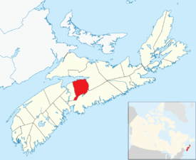 Location of District of the Municipality of East Hants | |||
| Coordinates: 45°03′N 63°45′W / 45.05°N 63.75°W | |||
| Country |
| ||
| Province |
| ||
| County | Hants | ||
| Incorporated | April 17, 1879 | ||
| Electoral Districts Federal |
Kings—Hants | ||
| Provincial | Hants East | ||
| Government | |||
| • Type | East Hants Municipal Council | ||
| • Municipal Seat | Elmsdale | ||
| • Warden | Jim Smith | ||
| Area[1] | |||
| • Land | 1,786.56 km2 (689.79 sq mi) | ||
| Population (2016)[2] | |||
| • Total | 22,453 | ||
| • Change 2011-16 |
| ||
| • Census ranking | 185 of 4,870 | ||
| Time zone | UTC-4 (AST) | ||
| • Summer (DST) | UTC-3 (ADT) | ||
| Area code(s) | 902 | ||
| Dwellings | 8,753 | ||
| Median Income* | $56,591 CDN | ||
| Website | Official website | ||
| |||

East Hants, officially named the Municipality of the District of East Hants, is a district municipality in Hants County, Nova Scotia, Canada. Statistics Canada classifies the district municipality as a municipal district.
With its administrative seat in Elmsdale, the district municipality occupies the eastern half of Hants County from the Minas Basin to the boundary with Halifax County, sharing this boundary with the Municipality of the District of West Hants. It was made in 1861 from the former townships of Uniacke, Rawdon, Douglas, Walton, Shubenacadie and Maitland. Its most settled area is in the Shubenacadie Valley.
Demographics
In the 2016 Census of Population conducted by Statistics Canada, the Municipality of the District of East Hants recorded a population of 22,453 living in 9,057 of its 9,930 total private dwellings, a change of 1.5% from its 2011 population of 22,111. With a land area of 1,786.56 km2 (689.79 sq mi), it had a population density of 12.6/km2 (32.6/sq mi) in 2016.[2]
|
|
Public Works
The Public Works division operates two water utility distribution sites and three sewage collection and treatment systems for communities in the serviced areas adjacent to Highway 102 and along the Shubenacadie River. The division also operates an engineered spring which draws additional water from Grand Lake to the Shubenacadie River during low water level events.
Drinking water is distributed across 71.0 kilometers of main distribution lines. Wastewater is distributed through 80.5 kilometers of wastewater collection mains. Please visit the Public Works section for more detailed information.
The Environmental Services division works closely with Public Works. This division monitors and reviews data to ensure compliance of operating approvals. Environmental Services also runs a watershed protection program that focuses on building awareness of watershed issues that impact watersheds of interest to the municipality.[4]
Notable people
- Hip hop artist Buck 65 is from Mount Uniacke, East Hants. Born Richard Terfry, he is also a radio host on CBC Radio.
- Luke Boyd, international recording artist better known as Classified, was born in Enfield, East Hants.
Communities
- Admiral Rock
- Belnan
- Burntcoat Head
- Centre Rawdon
- Clarksville
- Densmore Mills
- East Gore
- East Uniacke
- Elmsdale
- Enfield
- Five Mile River
- Georgefield
- Gore
- Gormanville
- Greenfield
- Hardwood Lands
- Hillsvale
- Indian Brook
- Kennetcook
- Lantz
- Latties Brook
- Maitland
- Maple Grove
- McPhees Corner
- Milford Station
- Moose Brook
- Mount Uniacke
- Nine Mile River
- Noel
- Noel Road
- Noel Shore
- North Noel Road
- Northfield
- Rawdon Gold Mines
- Renfrew
- Riverside Corner
- Roulston Corner
- Selma
- Shubenacadie
- South Maitland
- South Rawdon
- Stanley
- Tenecape
- Upper Kennetcook
- Upper Rawdon
- Urbania
- Walton
- West Gore
- White Settlement
Education
- Riverside Educational Centre middle school is located in Milford Station
- Elmsdale District School is located in Elmsdale
- Kennetcook District Elementary is located in Kennetcook
- Uniacke District School is located in Mount Uniacke
- Hants East Rural High School is located in Milford Station
- Hants North Rural High School is located in Kennetcook
See also
References
- 1 2 Hants&SearchType=Begins&SearchPR=01&B1=Custom&Custom=1000,7000,8000 2006 Statistics Canada Community Profile: East Hants Municipal District, Nova Scotia
- 1 2 "Population and dwelling counts, for Canada, provinces and territories, and census subdivisions (municipalities), 2016 and 2011 censuses – 100% data (Nova Scotia)". Statistics Canada. February 8, 2017. Retrieved February 12, 2017.
- ↑ Statistics Canada: 1996, 2001, 2006 census
- ↑ http://easthants.maps.arcgis.com/apps/MapSeries/index.html?appid=204267fffd75456bb8d5d02ab1d0d8ce
External links
Places adjacent to Municipality of the District of East Hants | ||||||||||
|---|---|---|---|---|---|---|---|---|---|---|
| ||||||||||
| Historical counties | |
|---|---|
| Economic regions | |
| Regional municipalities | |
| County municipalities | |
| District municipalities | |
| Towns | |
| Villages | |
| Lists | |
| |