East Caprivi
| Republic of East Caprivi Republiek van Oos-Caprivi Republik Ostcaprivi | |||||||||
|---|---|---|---|---|---|---|---|---|---|
| 1972–1989 | |||||||||
 Flag
 Coat of arms
| |||||||||
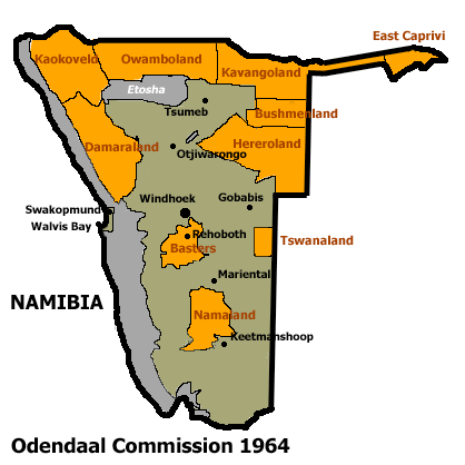 Allocation of Land to bantustans according to the Odendaal Plan. East Caprivi is in the top right corner. | |||||||||
 Map of the bantustan | |||||||||
| Status | Bantustan | ||||||||
| Capital | Katima Mulilo | ||||||||
| Common languages |
Lozi English Afrikaans German | ||||||||
| History | |||||||||
• Self-government | 1972 | ||||||||
• Re-integrated into Namibia | May 1989 | ||||||||
| Currency | South African rand | ||||||||
| |||||||||
East Caprivi was a bantustan in South West Africa (present-day Namibia), intended by the apartheid government to be a self-governing homeland for the Lozi people. It was set up in 1972, in the very corner of the Namibian panhandle called Caprivi Strip. It was granted a self-governing status in 1976. The homeland was renamed Lozi soon after. Not like the other homelands in South West Africa, Lozi was directly administrated through the Department of Bantu Administration and Development in Pretoria.[1]
Lozi, like other homelands in South West Africa, was abolished in May 1989 at the start of the transition to independence.
See also
| |||||||||||||||||||||||||||||||||||||||||||||||||||||||||||||||||||||||||||||||||||||||||||||||||||||||||||
References
- ↑ Lenggenhager, Luregn (2015-05-04). "Nature, War and Development: South Africa's Caprivi Strip, 1960–1980". Journal of Southern African Studies. 41 (3): 467–483. doi:10.1080/03057070.2015.1025337. ISSN 0305-7070.
Coordinates: 17°46′10″S 24°12′49″E / 17.76944°S 24.21361°E
This article is issued from
Wikipedia.
The text is licensed under Creative Commons - Attribution - Sharealike.
Additional terms may apply for the media files.