East 34th Street Bridge
| East 34th Street Bridge | |||||||||||||||||||||||||
|---|---|---|---|---|---|---|---|---|---|---|---|---|---|---|---|---|---|---|---|---|---|---|---|---|---|
 | |||||||||||||||||||||||||
| Coordinates | 47°13′50″N 122°25′44″W / 47.2306°N 122.429°WCoordinates: 47°13′50″N 122°25′44″W / 47.2306°N 122.429°W | ||||||||||||||||||||||||
| Carries | East 34th Street | ||||||||||||||||||||||||
| Locale | Tacoma, Washington | ||||||||||||||||||||||||
| Heritage status | NRHP | ||||||||||||||||||||||||
| Characteristics | |||||||||||||||||||||||||
| Design | Open-spandrel arch | ||||||||||||||||||||||||
| Material | Concrete | ||||||||||||||||||||||||
| Total length | 485-foot (148 m) | ||||||||||||||||||||||||
| History | |||||||||||||||||||||||||
| Architect | Forsbeck, C.D.; MacRae | ||||||||||||||||||||||||
| Construction end | 1937 | ||||||||||||||||||||||||
| |||||||||||||||||||||||||

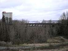
The East 34th Street Bridge is a concrete open-spandrel bridge in Tacoma, Washington. The bridge was built in 1937 to replace a wood bridge that had previously spanned the gulch. The bridge is constructed of two rib arches, that are supported by 24-foot (7 m) support legs, with spandrel columns between the arches and the bridge's 485-foot (148 m) deck. The concrete railings on the deck are adorned with urn-shaped lampposts.[2]
The bridge was added to the National Register of Historic Places in 1982.
References
- ↑ National Park Service (2007-01-23). "National Register Information System". National Register of Historic Places. National Park Service.
- ↑ Holstine 2005, p. 202
Sources
- Holstine, Craig; Hobbs, Richard (2005). Spanning Washington: Historic Highway Bridges of the Evergreen State, Washington State University Press, ISBN 0-87422-281-8.
| Topics | |
|---|---|
| Lists by states |
|
| Lists by insular areas | |
| Lists by associated states | |
| Other areas | |
| |
This article is issued from
Wikipedia.
The text is licensed under Creative Commons - Attribution - Sharealike.
Additional terms may apply for the media files.