Dresden, Kansas
| Dresden, Kansas | |
|---|---|
| City | |
 Location within Decatur County and Kansas | |
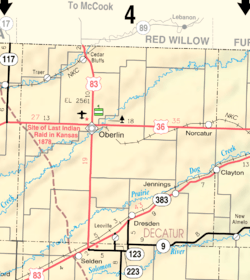 KDOT map of Decatur County (legend) | |
| Coordinates: 39°37′20″N 100°25′17″W / 39.62222°N 100.42139°WCoordinates: 39°37′20″N 100°25′17″W / 39.62222°N 100.42139°W | |
| Country | United States |
| State | Kansas |
| County | Decatur |
| Area[1] | |
| • Total | 0.94 sq mi (2.43 km2) |
| • Land | 0.94 sq mi (2.43 km2) |
| • Water | 0 sq mi (0 km2) |
| Elevation | 2,733 ft (833 m) |
| Population (2010)[2] | |
| • Total | 41 |
| • Estimate (2016)[3] | 40 |
| • Density | 44/sq mi (17/km2) |
| Time zone | UTC-6 (CST) |
| • Summer (DST) | UTC-5 (CDT) |
| ZIP code | 67635 |
| Area code | 785 |
| FIPS code | 20-18600 [4] |
| GNIS feature ID | 0471072 [5] |
Dresden is a city in Decatur County, Kansas, United States. As of the 2010 census, the city population was 41.[6]
History
Dresden was founded in 1888.[7] It was named by German settlers after the city of Dresden, in Germany.[8][9]
The first post office in Dresden was established in October, 1888.[10]
Dresden was a station on the Chicago, Rock Island and Pacific Railroad.[11]
Geography
Dresden is located at 39°37′20″N 100°25′17″W / 39.62222°N 100.42139°W (39.622221, -100.421403).[12] According to the United States Census Bureau, the city has a total area of 0.94 square miles (2.43 km2), all of it land.[1]
Demographics
| Historical population | |||
|---|---|---|---|
| Census | Pop. | %± | |
| 1930 | 231 | — | |
| 1940 | 180 | −22.1% | |
| 1950 | 162 | −10.0% | |
| 1960 | 134 | −17.3% | |
| 1970 | 103 | −23.1% | |
| 1980 | 84 | −18.4% | |
| 1990 | 73 | −13.1% | |
| 2000 | 51 | −30.1% | |
| 2010 | 41 | −19.6% | |
| Est. 2016 | 40 | [3] | −2.4% |
| U.S. Decennial Census | |||
2010 census
As of the census[2] of 2010, there were 41 people, 19 households, and 12 families residing in the city. The population density was 43.6 inhabitants per square mile (16.8/km2). There were 29 housing units at an average density of 30.9 per square mile (11.9/km2). The racial makeup of the city was 100.0% White.
There were 19 households of which 21.1% had children under the age of 18 living with them, 57.9% were married couples living together, 5.3% had a male householder with no wife present, and 36.8% were non-families. 31.6% of all households were made up of individuals and 15.8% had someone living alone who was 65 years of age or older. The average household size was 2.16 and the average family size was 2.75.
The median age in the city was 49.8 years. 22% of residents were under the age of 18; 0.0% were between the ages of 18 and 24; 19.5% were from 25 to 44; 24.4% were from 45 to 64; and 34.1% were 65 years of age or older. The gender makeup of the city was 51.2% male and 48.8% female.
2000 census
As of the census[4] of 2000, there were 51 people, 23 households, and 16 families residing in the city. The population density was 54.1 people per square mile (20.9/km²). There were 28 housing units at an average density of 29.7 per square mile (11.5/km²). The racial makeup of the city was 100.00% White.
There were 23 households out of which 17.4% had children under the age of 18 living with them, 73.9% were married couples living together, and 26.1% were non-families. 26.1% of all households were made up of individuals and 4.3% had someone living alone who was 65 years of age or older. The average household size was 2.22 and the average family size was 2.65.
In the city, the population was spread out with 19.6% under the age of 18, 2.0% from 18 to 24, 25.5% from 25 to 44, 23.5% from 45 to 64, and 29.4% who were 65 years of age or older. The median age was 50 years. For every 100 females, there were 121.7 males. For every 100 females age 18 and over, there were 115.8 males.
The median income for a household in the city was $24,375, and the median income for a family was $31,500. Males had a median income of $12,500 versus $11,250 for females. The per capita income for the city was $17,236. None of the population and none of the families were below the poverty line.
References
- 1 2 "US Gazetteer files 2010". United States Census Bureau. Archived from the original on 2012-07-14. Retrieved 2012-07-06.
- 1 2 "American FactFinder". United States Census Bureau. Retrieved 2012-07-06.
- 1 2 "Population and Housing Unit Estimates". Retrieved June 9, 2017.
- 1 2 "American FactFinder". United States Census Bureau. Archived from the original on 2013-09-11. Retrieved 2008-01-31.
- ↑ "US Board on Geographic Names". United States Geological Survey. 2007-10-25. Retrieved 2008-01-31.
- ↑ "2010 City Population and Housing Occupancy Status". U.S. Census Bureau. Archived from the original on July 21, 2011. Retrieved September 14, 2011.
- ↑ "Decatur County". Blue Skyways. Kansas State Library. Retrieved 7 June 2014.
- ↑ "Profile for Dresden, Kansas". ePodunk. Retrieved 8 June 2014.
- ↑ Federal Writers' Project (1939). Kansas, a Guide to the Sunflower State. Works Progress Administration. p. 448.
- ↑ "Kansas Post Offices, 1828-1961 (archived)". Kansas Historical Society. Archived from the original on October 9, 2013. Retrieved 8 June 2014.
- ↑ Blackmar, Frank Wilson (1912). Kansas: A Cyclopedia of State History, Embracing Events, Institutions, Industries, Counties, Cities, Towns, Prominent Persons, Etc. Standard Publishing Company. p. 547.
- ↑ "US Gazetteer files: 2010, 2000, and 1990". United States Census Bureau. 2011-02-12. Retrieved 2011-04-23.
External links
| Wikimedia Commons has media related to Dresden, Kansas. |
- City
- Schools
- USD 294, local school district
- Maps
- Dresden City Map, KDOT
Municipalities and communities of Decatur County, Kansas, United States | ||
|---|---|---|
| Cities | 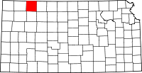 | |
| Unincorporated communities | ||
| Ghost towns | ||
| Townships | ||
| Footnotes | ‡This populated place also has portions in an adjacent county or counties | |