Downtown Manhattan Historic District
|
Downtown Manhattan Historic District | |
 | |
  | |
| Location | Generally including the blks bet. Humboldt and Pierre Sts. from 3rd to 5th Sts., Manhattan, Kansas |
|---|---|
| Coordinates | 39°10′44″N 96°33′42″W / 39.17889°N 96.56167°WCoordinates: 39°10′44″N 96°33′42″W / 39.17889°N 96.56167°W |
| Area | 25.8 acres (10.4 ha) |
| Architect | J.C. Holland; F. Squires; et al. |
| Architectural style | Early Commercial, Queen Anne, et al. |
| NRHP reference # | 06001240[1] |
| Added to NRHP | October 2, 2007 |
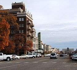
The Downtown Manhattan Historic District in Manhattan, Kansas is a 25.8 acres (10.4 ha) historic district which was listed on the National Register of Historic Places in 2007. The district generally includes the blocks between Humboldt and Pierre Sts. from 3rd to 5th Sts.[1]
The district includes 48 contributing buildings and 15 non-contributing buildings. Selected buildings are:
- Manhattan State Bank Building (1906), 400 Poyntz
- Wareham Theater (1910), 408-412 Poyntz[2]
References
- 1 2 National Park Service (2010-07-09). "National Register Information System". National Register of Historic Places. National Park Service.
- ↑ Brenda R. Spencer; Christy Davis (July 28, 2006). "National Register of Historic Places Inventory/Nomination: Downtown Manhattan Historic District". National Park Service. Retrieved December 31, 2017. With photos.
| Topics | |
|---|---|
| Lists by states |
|
| Lists by insular areas | |
| Lists by associated states | |
| Other areas | |
| |
This article is issued from
Wikipedia.
The text is licensed under Creative Commons - Attribution - Sharealike.
Additional terms may apply for the media files.