Douro (intermunicipal community)
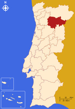
The Comunidade Intermunicipal do Douro is an administrative division in Portugal. It replaced the Comunidade Urbana do Douro, created in 2004.[1] It takes its name from the Douro River. The seat of the intermunicipal community is Vila Real. Douro comprises parts of the former districts of Bragança, Guarda, Vila Real and Viseu. The population in 2011 was 205,157,[2] in an area of 4,031.58 km².[3]
Douro is also a NUTS3 subregion of Norte Region. The subregion Douro covers the same area as the intermunicipal community, but including the municipalities Murça (Alto Trás-os-Montes intermunicipal community), and excluding the municipality Vila Flor. As of 2011, the subregion had a population of 205,902[2] and a total area of 4,108 km².[3]
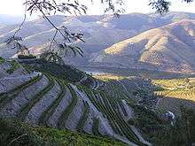
Its economic activity is largely centered on the production of wine, particularly port, and also non-fortified Douro wine from the Douro DOC wine region. The entire region is mountainous and crossed by steep valleys.
Municipalities
The CIM Douro is composed of 19 municipalities:[4]
| Municipality | Population (2011)[2] | Area (km²)[3] | NUTS III region |
|---|---|---|---|
| Murça | 5,952 | 189.37 | Alto Trás-os-Montes |
| Alijó | 11,942 | 297.60 | Douro |
| Armamar | 6,297 | 117.24 | Douro |
| Carrazeda de Ansiães | 6,373 | 279.24 | Douro |
| Freixo de Espada à Cinta | 3,780 | 244.14 | Douro |
| Lamego | 26,691 | 165.42 | Douro |
| Mesão Frio | 4,433 | 26.65 | Douro |
| Moimenta da Beira | 10,212 | 219.97 | Douro |
| Penedono | 2,952 | 133.71 | Douro |
| Peso da Régua | 17,131 | 94.86 | Douro |
| Sabrosa | 6,361 | 156.92 | Douro |
| Santa Marta de Penaguião | 7,356 | 69.28 | Douro |
| São João da Pesqueira | 7,874 | 266.11 | Douro |
| Sernancelhe | 5,671 | 228.61 | Douro |
| Tabuaço | 6,350 | 133.86 | Douro |
| Tarouca | 8,046 | 100.08 | Douro |
| Torre de Moncorvo | 8,572 | 531.56 | Douro |
| Vila Nova de Foz Côa | 7,312 | 398.15 | Douro |
| Vila Real | 51,850 | 378.80 | Douro |
| Total | 205,157 | 4,031.58 |
Geography
The main rivers are Douro River, Corgo River, Tua River and Sabor River. There is an airport at Vila Real: Aerodromo de Vila Real/Douro [VRL]. The Douro railway line was completed in 1887. The narrow gauge branch lines in the area (such as the Corgo line) are now all closed.
The main monuments are the cathedral and Mateus Palace in Vila Real, and the Remedios and Sé/cathedral in Lamego. The Alto Douro Wine Region and the Prehistoric Rock-Art Site of the Côa Valley are both classified by UNESCO as heritage sites.
The University of Trás-os-Montes and Alto Douro is situated in Vila Real.
References
- ↑ CM Vila Nova de Foz Côa
- 1 2 3 Instituto Nacional de Estatística
- 1 2 3 Direção-Geral do Território
- ↑ "Law nr. 75/2013" (pdf). Diário da República (in Portuguese). Assembly of the Republic (Portugal). Retrieved 18 August 2014.
External links
| Norte Region |
| ||||
|---|---|---|---|---|---|
| Centro Region |
| ||||
| Lisboa Region |
| ||||
| Alentejo Region |
| ||||
| Algarve Region |
| ||||
| Autonomous Regions | |||||
All these divisions are further subdivided into municipalities and parishes. | |||||