Alentejo

(Ponte de Sor [according to the interpretations, in Alentejo or, alternatively, in Ribatejo] in light orange)
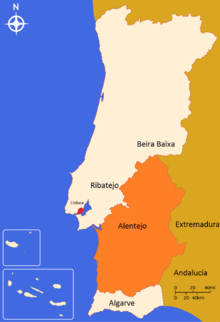
The Alentejo (IPA: [ɐlɐ̃j̃ˈtɛʒu]) is a geographical, historical and cultural region of south-central and southern Portugal. In Portuguese, it literally means "beyond" (além) Tagus river (Tejo).
Alentejo includes the regions of Alto Alentejo and Baixo Alentejo. It corresponds to the districts of Beja, Évora, Portalegre and the Alentejo Litoral. The main cities are: Évora, Beja, Serpa, Estremoz, Elvas and Portalegre.
It has borders with Beira Baixa in the North, with Spain (Andalucia and Extremadura in the east, with the Algarve in the South and with the Atlantic Ocean, Ribatejo and Estremadura in the West.
The Alentejo is a region known for its traditional polyphonic singing groups, similar to those found in Tuscany, Corsica, and elsewhere.
History
The comarca of the Alentejo became the Alentejo Province, divided into upper (Alto Alentejo Province) and lower (Baixo Alentejo Province) designations. The modern region of the Alentejo was expropriated from the medieval provinces and historical territories of Estremadura Province (specifically the 1936 portions of the Ribatejo). The term "Entre-Tejo-e-Guadiana" has become obsolete; it referred to roughly the same land area between the Tagus and the Guadiana rivers part of the Kingdom of Portugal.
Geography
Dimensions
Alentejo's area extends to 27,272 square kilometres (10,530 square miles) (29.6% of the country) and has a population of 537,556 (5.1% of the country). Excluding Ponte de Sor, its area is 26,432 km2 (10,205 sq mi) and its population 520,834. The population density of Alentejo is 19.1/km².

Topography
Topographically, the countryside varies from the open rolling plains of the south of the Alentejo to the granite hills that border Spain in the north-east. To feed the water needs of this considerable area a number of public dams have been constructed, most notably the Alqueva Dam. The landscape is primarily one of soft rolling hills and plains, with conspicuous shrubs and the native cork oaks and holly/holm oaks, the established olive trees and grapevines, plus some large scale toilet roll production of eucalyptus trees and some native trees. In the north, traditional economic activity may be more livestock-based as typified by cow, sheep, and pig (both white and black) farming. To the south agriculture may be more predominant.
.jpg)

.jpg)
Biome
Parque Natural da Serra de São Mamede, a Nature Park Area located to the east of Portalegre, includes medieval villages. In the south near Mértola there is another Nature Park Area named Parque Natural do Vale Guadiana. This is more scarcely inhabited than the former. To the west, the coastal strip that runs from the port of Sines down to Cape St. Vincent (this already in the Algarve) comprises the Southwest Alentejo and Vicentine Coast Natural Park.
Climate
The climate of the region is typically warm and dry for a large part of the year, with summer temperatures occasionally reaching up to 40 °C (104 °F), while winters are relatively mild and wet. The climate is not uniform throughout the region though: mid-summer temperatures in coastal areas are usually much lower (often around 25 °C (77 °F)) than inland ones (which frequently hover around 35 °C (95 °F)). This much resembles the contrast between Casablanca and the Moroccan interior, where the presence of the nearby Atlantic Ocean gives rise to marked temperature differences between coastal and even nearby inland zones. Usually, the warmest temperatures can be found in the southernmost inland parts of the region, along the Guadiana valley between Mertola and Juromenha, particularly in the areas close to Moura. However, the hottest days tend to deviate from the usual pattern and will arise when the winds are east or southeast and very hot air with temperature reaching 25 °C (77 °F) or more at 850 hPA level (near 1500 metres' height usually) enter Iberia from Africa. If the winds are strong enough another deep and very low lying valley, the one of the river Sado, becomes extremely warm by European standards. Places like Alvalade do Sado and Alcacer do Sal, but basically the whole Sado valley below 75 metres (246 ft) can reach 45 °C (113 °F) under extreme circumstances and 40 °C (104 °F) in the summer is regularly reached each year. Despite the fact that they are relatively close to the coast. The highest temperature ever recorded in Portugal and in fact Europe (this century) was measured on the first of August 2003 in Amareleja and reached 47.4 °C (117.3 °F). Since the meteorological station is about 100 metres (330 ft) above the nearby valley near Moura it is very likely that about 48.5 °C (119.3 °F) was reached there but no measurements were taken. What is most impressive and unique in Europe was a stretch of no less than 17 consecutive days at Amareleja with a maximum temperature of 40 °C (104 °F) or more (reaching an average over the period of 43,5 C). This was only equaled over the same period in Cordoba Spain, the average over there however was 42.4 °C (108.3 °F) so slightly less hot over the same period. Finally the average daytime maximum temperatures reach 35 to 36 °C (95 to 97 °F) in July and August near Moura, 33 to 34 °C (91 to 93 °F) in the Sado Valley (and other inland valleys away from the coast). Many parts, however, are above 200 or even 300 m which leads to clearly lower average temperatures also in summer. It is very likely that the Guadiana river valley away from the coast is the second-hottest on average in Europe after the inland part of the Spanish Guadalquivir region especially near Cordoba. The extremes in this valley, however, are somewhat lower (most just above 46 °C (115 °F)). Portugal including the Alentejo region are not escaping global warming and the average temperatures are clearly on the rise. Some climate models indicate daytime average maximum temperatures nearing 45 °C (113 °F) in the Guadiana valley by 2100, which is the current average in the hottest places of the Sahara.
Education
By the acceptable standards of a developed country, the illiteracy rate in the region may still be surprisingly high among those older than 60, in contrast with the younger generations. The rate of coverage of pre-primary education is among the highest in the country.
Institutions of higher education include:
- Polytechnic Institute of Beja
- Instituto Politécnico de Portalegre
- University of Évora
Economy

The area is commonly known as the "bread basket" of Portugal, a region of vast open countryside with undulating plains and rich fertile soil. With very few exceptions all the major towns are mainly reliant on agriculture, livestock and forestry. There are several types of traditional cheeses, wines and smoked hams and sausages made in the Alentejo region, among others: Queijo Serpa, Queijo de Évora and Queijo de Nisa (PDO cheeses); Vinho do Alentejo and Vinho do Redondo (wines); and presunto (smoked ham). Marble, cork, olive oil and mining industries are other important activities in the region and tourism is expected to still have growth potential. The Alqueva Dam is an important irrigation and hydroelectricity generation facility which supports a part of the Alentejo's economy.
The region is the home of the world's most important area for the growing of cork. Cork-oak, known in Portugal as "sobreiro", has been grown commercially in the region for the past 300 years, with the areas between the trees typically given over to grazing, or on the more productive soils, to the growing of citrus fruit, vines or olives. As a consequence, a uniquely rich and varied ecosystem has developed. The bark of the cork-oak is still harvested by teams of men using locally made hand-axes. No mechanical method has yet been invented that will allow the harvest to be achieved as effectively. The stripping of the bark is performed only in mid-Summer, when the bark can be removed more easily. The cork-oak is the only tree known that will allow this regular stripping of bark without damage. The harvest of one mature tree provides sufficient bark to produce about 4,000 wine bottle corks. The industry provides employment for about 60,000 workers.[1]
See also
References
- ↑ BBC, "Natural World: Cork – Forest in a Bottle", BBC2, broadcast 8.00 pm, Tuesday, 9 December 2008.
External links
- Melhor Alentejo – Official website
| Wikisource has the text of the 1911 Encyclopædia Britannica article Alemtejo. |