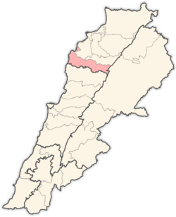
Douma, Lebanon
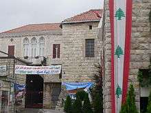


Douma (Arabic: دوما) is a Lebanese village located at an altitude of 1150 m. It is 80 km from Beirut, 30 km from Jbeil and 43 km from Tripoli. Douma is a part of Batroun District and is known for its special location in a valley surrounded by mountains. Almost all its houses are made of red brick. It enjoys a unique temperate climate praised by physicians as the ultimate place of medical refuge. Its ground is rich and welcomes all sorts of plants especially and has an abundance olive trees, grapevines and apple trees.
History
Douma witnessed different civilizations including ancient Greece, ancient Rome and Turkey. However, the Ottoman Empire left the largest impact on Douma's inhabitants.
In the town square sits a 4th-century A.D. sarcophagus, bearing a Greek inscription recording that this was the burial place of Castor, who died in 317 A.D.
Emir Youssef Shehab brought Christians to the town, in hope of getting better crop and thus better taxes. Since then the village has become a Christian village, with most of its believers members of the Greek Orthodox Church.
In the 1920s, the leaders of Syria who had just rebelled against the French, were detained and exhiled to Douma of Lebanon. One of those leaders was Sa’dallah al-Jabiri who was destined to become Syria’s first Prime Minister after its independence in the 1940s. Another one was a main author of Syria’s constitution: lawyer Safadi.
Origin of the name
The name Douma is of Greek origin meaning "house", "palace" or "castle". Douma is also named "Douma El Hadid" (Douma of Iron or Iron-Douma) due to the abundance of iron found in its soil and the superior craftsmanship of its blacksmiths. The arming industry established under Ibrahimn Basha's regime encouraged many people from Showeir to come and settle in Douma since opportunities of work were plentiful at the time.
Climate
In Douma, there is a Mediterranean climate. Rainfall is higher in winter than in summer. The Köppen-Geiger climate classification is Csa. The average annual temperature in Douma is 15.2 °C (59.4 °F). About 1,210 mm (47.64 in) of precipitation falls annually.
| Climate data for Douma | |||||||||||||
|---|---|---|---|---|---|---|---|---|---|---|---|---|---|
| Month | Jan | Feb | Mar | Apr | May | Jun | Jul | Aug | Sep | Oct | Nov | Dec | Year |
| Average high °C (°F) | 10.7 (51.3) |
11.0 (51.8) |
13.8 (56.8) |
18.9 (66) |
23.4 (74.1) |
27.2 (81) |
29.5 (85.1) |
30.1 (86.2) |
27.2 (81) |
23.6 (74.5) |
17.9 (64.2) |
13.3 (55.9) |
20.6 (69) |
| Average low °C (°F) | 2.8 (37) |
3.1 (37.6) |
4.7 (40.5) |
8.1 (46.6) |
11.6 (52.9) |
14.7 (58.5) |
16.4 (61.5) |
17.2 (63) |
14.7 (58.5) |
12.3 (54.1) |
8.4 (47.1) |
4.9 (40.8) |
9.9 (49.8) |
| Average precipitation mm (inches) | 265 (10.43) |
222 (8.74) |
202 (7.95) |
87 (3.43) |
35 (1.38) |
2 (0.08) |
1 (0.04) |
1 (0.04) |
9 (0.35) |
43 (1.69) |
124 (4.88) |
219 (8.62) |
1,210 (47.64) |
| Source: Climate-Data.org,Climate data | |||||||||||||
Development
The majority of the infrastructure and housing in Douma was built between 1881 and 1914. This was the golden age in the life of Douma financed by the money sent by emigrants in Brazil, Argentina and the USA.
International relations
Douma is twinned with:

External links
- Duma, Localiban
Capital: Batroun | ||
| Towns and villages |
|  |