Dores do Rio Preto
| Dores do Rio Preto | |
|---|---|
| Municipality | |
| The Municipality of Dores do Rio Preto | |
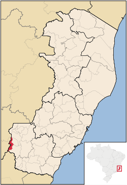 Location of Dores do Rio Preto in the State of Espírito Santo | |
| Coordinates: 20°41′20″S 41°50′42″W / 20.68889°S 41.84500°WCoordinates: 20°41′20″S 41°50′42″W / 20.68889°S 41.84500°W | |
| Country |
|
| Region | Southeast |
| State |
|
| Founded | April 7, 1964 |
| Government | |
| • Mayor | Cláudia Martins Bastos (PSDB) |
| Area | |
| • Total | 153.106 km2 (59.115 sq mi) |
| [1] | |
| Elevation | 55 m (180 ft) |
| Population (2008) | |
| • Total | 6,288 |
| • Density | 44.9/km2 (116/sq mi) |
| [2] | |
| Time zone | UTC-3 (UTC-3) |
| HDI (2000) | 0.674 – medium[3] |
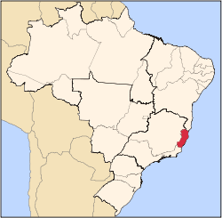
Dores do Rio Preto is the westernmost municipality in the Brazilian state of Espírito Santo. Its population was 6,288 (2008) and its area is 153.106 km². The village Pedras Meninas in Dores is the location for the entrance to Caparaó National Park and the Pico da Bandeira from Espirito Santo.
References
- ↑ IBGE - "Archived copy". Archived from the original on 2007-01-09. Retrieved 2014-08-03.
- ↑ IBGE 2008 statistics
- ↑ "Archived copy". Archived from the original on 2009-10-03. Retrieved 2009-12-17. UNDP
Capital: Vitória | ||||||||||
| Mesoregion Central |
|  | ||||||||
| Mesoregion Litoral Norte |
| |||||||||
| Mesoregion Noroeste |
| |||||||||
| Mesoregion Sul |
| |||||||||
This article is issued from
Wikipedia.
The text is licensed under Creative Commons - Attribution - Sharealike.
Additional terms may apply for the media files.