Doniphan County Courthouse Square Historic District
|
Doniphan County Courthouse Square Historic District | |
 | |
  | |
| Location | Roughly bounded by E. Walnut, E Chestnut, S. Main, S. Liberty Sts., Troy, Kansas |
|---|---|
| Coordinates | 39°47′10″N 95°05′21″W / 39.78611°N 95.08917°WCoordinates: 39°47′10″N 95°05′21″W / 39.78611°N 95.08917°W |
| Area | 4.6 acres (1.9 ha) |
| Built | 1899 |
| Architectural style | Italianate, Queen Anne |
| NRHP reference # | 02000717[1] |
| Added to NRHP | July 3, 2002 |
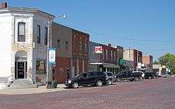
The Doniphan County Courthouse Square Historic District in Troy, Kansas is a 4.6 acres (1.9 ha) historic district which was listed on the National Register of Historic Places in 2002. It is roughly bounded by E. Walnut, E Chestnut, S. Main, and S. Liberty Streets. The district included 17 contributing buildings and one contributing site.[1]
It includes Italianate and Queen Anne architecture.
Its contributing buildings include:
- Doniphan County Courthouse (1906), which was previously separately listed on the National Register.
- Cyrus Leland Store Building (1911), 102 E. Walnut
- McClellan Mercantile Building (1900), 120 E. Walnut
- Mabel Perry Campbell House (c.1912), 115 E. Chestnut
- Sol Miller Building (c.1870), 101 S. Main
- Boder Brothers Bank/First National Bank (1872), 137 S. Main[2]
References
- 1 2 National Park Service (2010-07-09). "National Register Information System". National Register of Historic Places. National Park Service.
- ↑ Susan Jezak Ford (March 11, 2002). "National Register of Historic Places Registration: Doniphan County Courthouse Square Historic District". National Park Service. Retrieved December 28, 2017. With nine photos.
| Topics | |
|---|---|
| Lists by states |
|
| Lists by insular areas | |
| Lists by associated states | |
| Other areas | |
| |
This article is issued from
Wikipedia.
The text is licensed under Creative Commons - Attribution - Sharealike.
Additional terms may apply for the media files.