Don Gaspar Historic District
|
Don Gaspar Historic District | |
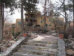 Inn of the Turquoise Bear | |
  | |
| Location | Roughly bounded by Old Santa Fe Trail, Paseo de Peralta, Don Cubero and Houghton, Santa Fe, New Mexico |
|---|---|
| Coordinates | 35°40′42″N 105°56′28″W / 35.67833°N 105.94111°WCoordinates: 35°40′42″N 105°56′28″W / 35.67833°N 105.94111°W |
| Area | 103 acres (42 ha) |
| Built | 1882 |
| Architect | Multiple |
| Architectural style | Bungalow/Craftsman, Pueblo |
| NRHP reference # | 83001629[1] |
| NMSRCP # | 891 |
| Significant dates | |
| Added to NRHP | July 21, 1983 |
| Designated NMSRCP | December 1, 1982 |
The Don Gaspar Historic District is one of the historic districts in Santa Fe, New Mexico.
It extends south from the State Capitol, and is part of the South Capitol area of Santa Fe. The northern boundary is Paseo de Peralta; the eastern boundary is the Old Santa Fe Trail; the southern boundary is Houghton Street, and the western boundary is Don Cubero (approximate).
The district is primarily residential, and was largely built up in the early 20th Century, although it was apparently subdivided in the late 19th Century and at least a few of the buildings date from this earlier period.
The mix of architectural styles includes California Bungalow, late-period Victorian and Pueblo Revival homes. Some of the homes are at least partially constructed from "pen tile" - structural tiles manufactured by the inmates of the New Mexico Penitentiary which was formerly located near the southwest end of the neighborhood. The district is transected by Don Gaspar Avenue and Galisteo Street, which run north-south.
See also
References
- ↑ National Park Service (2010-07-09). "National Register Information System". National Register of Historic Places. National Park Service.
| Topics | |
|---|---|
| Lists by states |
|
| Lists by insular areas | |
| Lists by associated states | |
| Other areas | |
| |