Don Chedi District
| Don Chedi ดอนเจดีย์ | |
|---|---|
| Amphoe | |
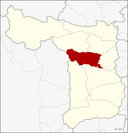 Amphoe location in Suphan Buri Province | |
| Coordinates: 14°38′06″N 100°01′18″E / 14.63500°N 100.02167°ECoordinates: 14°38′06″N 100°01′18″E / 14.63500°N 100.02167°E | |
| Country |
|
| Province | Suphan Buri |
| Seat | Don Chedi |
| Area | |
| • Total | 252.081 km2 (97.329 sq mi) |
| Population (2013) | |
| • Total | 453,839 |
| • Density | 179.8/km2 (466/sq mi) |
| Time zone | UTC+7 (THA) |
| Postal code | 72170 |
| Geocode | 7206 |
Don Chedi (Thai: ดอนเจดีย์, pronounced [dɔ̄ːn t͡ɕēːdīː]) is a district (amphoe) of Suphan Buri Province, Thailand.
Geography
Neighboring districts are (from the north clockwise) Nong Ya Sai, Sam Chuk, Si Prachan, Mueang Suphan Buri and U Thong, and in Kanchanaburi Province the district Lao Khwan.
History
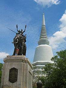
Prince Damrong Rajanubhab in 1913 discovered the remains of a large chedi within the district. He identified it as the one built by King Naresuan in 1593 after his win against the Burmese. The chedi was reconstructed in 1952. In 1959 a statue of the king on his war elephant cast by Silpa Bhirasri was added.
However, more recent research casts doubt on this identification. Although one of the chronicles explicitly places the battle at Suphan Buri, the others don't give any clear location. The Dutch merchant Jeremias van Vliet, however, wrote in his Short History of the Kings of Siam in 1640 that the battle took place near Ayutthaya - which would make Chedi Phu Khao Thong the likely place of this battle.
The area of the district was originally part of Si Prachan district. It was established as a minor district (King Amphoe) on January 1, 1962, consisting of the two tambon Don Chedi and Nong Sarai.[1] It was upgraded to a full district on July 27, 1965.[2]
Administration
Central administration
The district Don Chedi is subdivided into 5 subdistrict (tambon), which are further subdivided into 50 administrative villages (muban).
| No. | Name | Thai | Villages | Pop.[3] |
|---|---|---|---|---|
| 1. | Don Chedi | ดอนเจดีย์ | 9 | 14,634 |
| 2. | Nong Sarai | หนองสาหร่าย | 10 | 7,724 |
| 3. | Rai Rot | ไร่รถ | 10 | 7,398 |
| 4. | Sa Krachom | สระกระโจม | 9 | 8,682 |
| 5. | Thale Bok | ทะเลบก | 12 | 7,401 |
Local administration
There are 2 subdistrict municipalities (thesaban tambon) in the district:
- Don Chedi (Thai: เทศบาลตำบลดอนเจดีย์) consisting of parts of the subdistrict Don Chedi.
- Sa Krachom (Thai: เทศบาลตำบลสระกระโจม) consisting of parts of the subdistrict Sa Krachom.
There are 5 subdistrict administrative organizations (SAO) in the district:
- Don Chedi (Thai: องค์การบริหารส่วนตำบลดอนเจดีย์) consisting of parts of the subdistrict Don Chedi.
- Nong Sarai (Thai: องค์การบริหารส่วนตำบลหนองสาหร่าย) consisting of the complete subdistrict Nong Sarai.
- Rai Rot (Thai: องค์การบริหารส่วนตำบลไร่รถ) consisting of the complete subdistrict Rai Rot.
- Sa Krachom (Thai: องค์การบริหารส่วนตำบลสระกระโจม) consisting of parts of the subdistrict Sa Krachom.
- Thale Bok (Thai: องค์การบริหารส่วนตำบลทะเลบก) consisting of the complete subdistrict Thale Bok.
References
- ↑ ประกาศกระทรวงมหาดไทย เรื่อง การแบ่งท้องที่ตั้งเป็นกิ่งอำเภอ (PDF). Royal Gazette (in Thai). 79 (4 ง): 32–33. January 9, 1962.
- ↑ พระราชกฤษฎีกาตั้งอำเภอศรีสวัสดิ์ อำเภอสังขละบุรี อำเภอท่าคันโท อำเภอดอกคำใต้ อำเภอแม่ใจ อำเภอจุน อำเภอขามทะเลสอ อำเภอไพศาลี อำเภอท่าวังผา อำเภอบ้านกรวด อำเภอเด่นชัย อำเภอปทุมรัตต์ อำเภอกะเปอร์ อำเภออากาศอำนวย อำเภอดอนเจดีย์ อำเภอจอมพระ และอำเภอสามโก้ พ.ศ. ๒๕๐๘ (PDF). Royal Gazette (in Thai). 81 (49 ก): 565–569. July 27, 1965.
- ↑ "Population statistics 2013" (in Thai). Department of Provincial Administration. Retrieved 2014-10-04.