Dolní Lánov
| Dolní Lánov | |||
|---|---|---|---|
| Municipality and village | |||
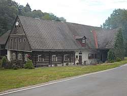 Typical log house (no. 96) | |||
| |||
| Coordinates: 50°36′N 15°40′E / 50.600°N 15.667°ECoordinates: 50°36′N 15°40′E / 50.600°N 15.667°E | |||
| Country |
| ||
| Region | Hradec Králové Region | ||
| District | Trutnov District | ||
| Area | |||
| • Total | 6.08 sq mi (15.76 km2) | ||
| Elevation | 1,398 ft (426 m) | ||
| Population (2017) | |||
| • Total | 770 | ||
| Time zone | UTC+1 (CET) | ||
| • Summer (DST) | UTC+2 (CEST) | ||
| ZIP code | 54341 | ||
| Website | www.dolnilanov.cz | ||
Dolní Lánov is a village and municipality in Trutnov District in the Hradec Králové Region of the Czech Republic. The municipality covers an area of 15.76 km² and as of 2017 it had a population of 770.
| Wikimedia Commons has media related to Dolní Lánov. |
This article is issued from
Wikipedia.
The text is licensed under Creative Commons - Attribution - Sharealike.
Additional terms may apply for the media files.