Dolls Point, New South Wales
| Dolls Point Sydney, New South Wales | |||||||||||||||
|---|---|---|---|---|---|---|---|---|---|---|---|---|---|---|---|
 Dolls Point Beach is located on the mouth of Georges River | |||||||||||||||
| Population | 1,661 (2016 census)[1] | ||||||||||||||
| Postcode(s) | 2219 | ||||||||||||||
| Location | 17 km (11 mi) south of Sydney CBD | ||||||||||||||
| LGA(s) | Bayside Council | ||||||||||||||
| State electorate(s) | Rockdale | ||||||||||||||
| Federal Division(s) | Cook | ||||||||||||||
| |||||||||||||||
Dolls Point is a small suburb in southern Sydney, in the state of New South Wales, Australia. Dolls Point is located 17 km south of the Sydney central business district and is part of the St George area. Dolls Point is in the local government area of the Bayside Council.
History
Dolls Point was originally a deserted landscape, which was considered uninhabitable. The origins of the name are unclear but legend has it that it was named for an escaped convict who took shelter in the dire landscape to hide from the authorities.[2]
The area between Cooks River and Georges River was originally known as Seven Mile Beach. It was changed to Lady Robinsons Beach in 1874 to honour the wife of Governor Sir Hercules Robinson. Cook Park is named after Samuel Cook who advocated it as a public pleasure area.
Historic Primrose House became the Royal South Sydney Community Health Centre.
Geography
Dolls Point takes its name from the geographical formation on Botany Bay. Cook Park runs along the eastern border and the beach stretches from Dolls Point to Sandringham Bay. Dolls Point is a quiet residential suburb that has managed to maintain an uncluttered landscape. Its village feel makes it a family friendly neighbourhood. It is home to fine sailing, water views and abundant parkland.
Dolls Point beach
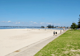
One of the main attractions is Doll Point Beach, which has the whitest sand in Sydney. Fishing and kite surfing are popular activities in the beach.[3] The beach sets out at the rock groyne and continues to the southwest for 550 metres past a seawall and a small tidal pool to a western deviation in the sandy shore at a groyne in front of a sailing club in Georges River. The beach is fairly precipitous and reflective, which is opposite of the deep 1 km wide river mouth to Towra Point.[4]
Commercial area
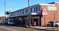
A small group of shops, along with the Sans Souci Library, are located at the intersection of Clareville Avenue and Russell Avenue, on the border with Sans Souci and Sandringham.
Population
According to the 2011 census of Population, there were 1,784 residents in Dolls Point. 39.5% stated they were born overseas with the top countries of birth being Greece 3.9%, China 2.9%, New Zealand 2.7%, England 2.4% and Egypt 2.2%. English was stated as the only language spoken at home by 58.0% of residents and the most common other languages spoken were Greek 11.6%, Arabic 4.1%, Spanish 3.1%, Macedonian 2.4% and Mandarin 2.3%. The most common responses for religious affiliation were Catholic 29.1%, Orthodox 17.5% and Anglican 13.6%.[1]
 Clareville Avenue, Dolls Point
_01.jpg) Primrose House
Primrose House.jpg) Malua Street
Malua Street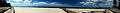 Dolls Point Beach - Peter Despina Reserve/Beach
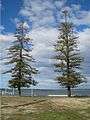 Cook Park
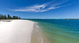 Dolls Point Beach
References
- 1 2 Australian Bureau of Statistics (27 June 2017). "Dolls Point (State Suburb)". 2016 Census QuickStats. Retrieved 11 April 2018.

- ↑ The Book of Sydney Suburbs, Compiled by Frances Pollon, Angus & Robertson Publishers, 1990, Published in Australia ISBN 0-207-14495-8, page 240
- ↑ Dolls Point Beach
- ↑ Dolls Point
External links
- http://www.DollsPoint.com/ Dolls Point Official Website
Coordinates: 33°59′38″S 151°08′35″E / 33.99386°S 151.14301°E