Banksmeadow
| Banksmeadow Sydney, New South Wales | |||||||||||||||
|---|---|---|---|---|---|---|---|---|---|---|---|---|---|---|---|
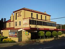 Botany Bay Hotel, Botany Road, Banksmeadow | |||||||||||||||
| Population | 12 (2011 census)[1] | ||||||||||||||
| • Density | 161/km2 (420/sq mi) | ||||||||||||||
| Postcode(s) | 2019 | ||||||||||||||
| Area | 3 km2 (1.2 sq mi) | ||||||||||||||
| Location | 11 km (7 mi) south of Sydney CBD | ||||||||||||||
| LGA(s) | Bayside Council | ||||||||||||||
| State electorate(s) | Maroubra | ||||||||||||||
| Federal Division(s) | Kingsford Smith | ||||||||||||||
| |||||||||||||||
Banksmeadow is a suburb of Sydney, in the state of New South Wales, Australia. Banksmeadow is located 11 kilometres south of the Sydney central business district, in the local government area of the Bayside Council. Banksmeadow sits on the northern shore of Botany Bay.
History
Banksmeadow is named in honour of naturalist Sir Joseph Banks, who travelled to Australia with Captain James Cook in 1770. Botany Bay is where they first landed ashore on 29 April 1770, when navigating around Australia on the Endeavour.[2]
Land use
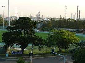
There is no residential land in Banksmeadow[3]. It is a largely industrial area with commercial and industrial developments associated with nearby Port Botany. This includes a number of oil terminals, the Sydenham-Botany Goods Railway and a large Orica Limited chemical facility.
Landmarks
Foreshore Beach (also known as Botany Beach) runs along the shore of Botany Bay. Part of the sandy public beach has been lost in recent years due to the expansion of port facilities by The Sydney Ports Corporation. A rock seawall along a large part of the beach has greatly restricted its use as a public beach. Water quality is poor and the beach is subject to major erosion. Sydney Ports are constructing two groynes to protect what remains of the beach. The area includes Banksmeadow Park and Botany Golf Course.
Schools
Banksmeadow Public School is located at the corner of Wiggins and Trevelyan Streets, Botany. It was established in 1881.[4]
References
- ↑ Australian Bureau of Statistics (31 October 2012). "Banksmeadow (State Suburb)". 2011 Census QuickStats. Retrieved 2012-07-07.

- ↑ The Book of Sydney Suburbs, Compiled by Frances Pollon, Angus & Robertson Publishers, 1990, p.18 ISBN 0-207-14495-8
- ↑ "Banksmeadow: The Sydney suburb with two pubs, a bakery but no-one lives there". Domain. 26 June 2018. Retrieved 28 June 2018.
- ↑ Banksmeadow Public School
External links
| Wikimedia Commons has media related to Banksmeadow, New South Wales. |
Coordinates: 33°57′26″S 151°12′25″E / 33.95731°S 151.20699°E