Doe Valley, Kentucky
| Doe Valley, Kentucky | |
|---|---|
| Unincorporated community | |
 Doe Valley, Kentucky  Doe Valley, Kentucky | |
| Coordinates: 37°57′24″N 86°07′00″W / 37.95667°N 86.11667°WCoordinates: 37°57′24″N 86°07′00″W / 37.95667°N 86.11667°W | |
| Country | United States |
| State | Kentucky |
| County | Meade |
| Area[1] | |
| • Total | 4.631 sq mi (11.99 km2) |
| • Land | 4.059 sq mi (10.51 km2) |
| • Water | 0.572 sq mi (1.48 km2) |
| Elevation | 607 ft (185 m) |
| Population (2010)[1] | |
| • Total | 1,931 |
| • Density | 420/sq mi (160/km2) |
| Time zone | UTC-5 (Eastern (EST)) |
| • Summer (DST) | UTC-4 (EDT) |
| Area code(s) | 270 & 364 |
| GNIS feature ID | 2631652[2] |
Doe Valley is an unincorporated community and census-designated place in Meade County, Kentucky, United States. Its population was 1,931 as of the 2010 census.[1]
Geography
According to the U.S. Census Bureau, the community has an area of 4.631 square miles (11.99 km2); 4.059 square miles (10.51 km2) of its area is land, and 0.572 square miles (1.48 km2) is water.[1]
References
- 1 2 3 4 "2010 Census Gazetteer Files - Places: Kentucky". U.S. Census Bureau. Retrieved April 2, 2017.
- ↑ "Doe Valley". Geographic Names Information System. United States Geological Survey.
Municipalities and communities of Meade County, Kentucky, United States | ||
|---|---|---|
| Cities | 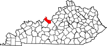 | |
| CDPs | ||
| Unincorporated communities | ||
| Footnotes | ‡This populated place also has portions in an adjacent county or counties | |
This article is issued from
Wikipedia.
The text is licensed under Creative Commons - Attribution - Sharealike.
Additional terms may apply for the media files.