Dobrzykowo, Warmian-Masurian Voivodeship
| Dobrzykowo | |
|---|---|
| Village | |
 | |
 Dobrzykowo | |
| Coordinates: 54°18′15″N 21°12′14″E / 54.30417°N 21.20389°E | |
| Country |
|
| Voivodeship | Warmian-Masurian |
| County | Kętrzyn |
| Gmina | Barciany |
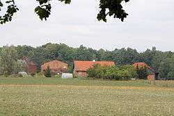
Dobrzykowo [dɔbʐɨˈkɔvɔ] (German: Dawerwalde)[1] is a village in the administrative district of Gmina Barciany, within Kętrzyn County, Warmian-Masurian Voivodeship, in northern Poland, close to the border with the Kaliningrad Oblast of Russia.[2] It lies approximately 14 kilometres (9 mi) north-west of Barciany, 28 km (17 mi) north-west of Kętrzyn, and 74 km (46 mi) north-east of the regional capital Olsztyn.
Before 1945 the area was part of Germany (East Prussia).
References
- ↑ "Former Territory of Germany" (in German). 2017-11-10.
- ↑ "Central Statistical Office (GUS) - TERYT (National Register of Territorial Land Apportionment Journal)" (in Polish). 2008-06-01.
Coordinates: 54°18′15″N 21°12′14″E / 54.30417°N 21.20389°E
This article is issued from
Wikipedia.
The text is licensed under Creative Commons - Attribution - Sharealike.
Additional terms may apply for the media files.