Dinghai District
| Dinghai 定海区 | |
|---|---|
| District | |
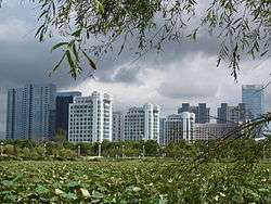
 Zhoushan New Town | |
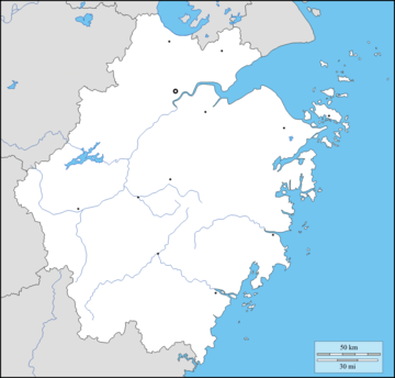 Dinghai Location in Zhejiang | |
| Coordinates: 30°01′10″N 122°06′10″E / 30.01944°N 122.10278°ECoordinates: 30°01′10″N 122°06′10″E / 30.01944°N 122.10278°E | |
| Country | People's Republic of China |
| Province | Zhejiang |
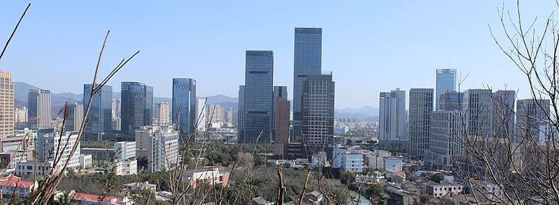
| Prefecture-level city | Zhoushan |
| Time zone | UTC+8 (China Standard) |
|
Dinghai (the former county) | |||||||||
| Chinese | 定海 | ||||||||
|---|---|---|---|---|---|---|---|---|---|
| Postal | Tinghai | ||||||||
| |||||||||
![]()
The district used to be a county. In 1987, it was combined with the neighbouring county of Putuo to form the city of Zhoushan.
Basic Information
- District Seat: Changguo Sub-District
- Population: 464,184[1] as of November 1, 2010
- Area: 1,444 km2 (558 sq mi) (568.8 km2 or 219.6 sq mi terrestrial, 875.2 km2 or 337.9 sq mi marine)
- Population Density: 816/km2 (2,110/sq mi)
- Gross Domestic Product: 31 billion yuan[2] as of 2011
- Per capita GDP: 66,784 yuan (approximately 10,740 US Dollars)
In addition to Zhoushan Main Island, other large islands include:
- Jintang (金塘)
- Cezi (册子)
- Changbai (长白)
- Changzhi (长峙)
- Banzhi (盘峙)
- Damao (大猫)
Administrative divisions

As of the close of 2014, Dinghai District administratively consisted of 9 sub-districts (街道; jiēdào) and 3 towns (镇; zhèn):[3]
Sub-districts:
- Changguo (昌国街道)
- Huannan (环南街道)
- Chengdong (城东街道)
- Yancang (盐仓街道)
- Lincheng (临城街道)
- Cengang (岑港街道)
- Ma'ao (马岙街道)
- Shuangqiao (双桥街道)
- Xiaosha (小沙街道)
Towns:
- Jintang (金塘镇)
- Baiquan (白泉镇)
- Ganlan (干𬒗镇): the second character is 𬒗(石览), which is often substituted with 缆.
Historically, Dinghai District administratively consisted of 6 subdistricts, 7 towns and 3 townships (乡; xiāng), which are listed below.
6 Sub-Districts:
- Jiefang (解放街道)
- Changguo (昌国街道)
- Huannan (环南街道) merges the defunct townships of Panzhi (盘峙) and Damao (大猫).
- Chengdong (城东街道) is the defunct township of Yang'ao (洋岙).
- Yancang (盐仓街道) is the defunct township of Yancang (盐仓).
- Lincheng (临城街道) is made up of defunct town(ship)s of Lincheng (临城) and Changzhi (长峙).
7 Towns:
- Jintang (金塘镇) is made up of defunct town(ship)s of Ligang (沥港), Shantan (山潭), Dafeng (大丰), and Liuhang (柳行).
- Baiquan (白泉镇) merges the defunct township of Gaoxie (皋泄).
- Cengang (岑港镇) merges defunct townships of Mamu (马目), and Yandun (烟墩).
- Ganlan (干𬒗镇)
- Xiaosha (小沙镇) merges the defunct township of Dasha (大沙).
- Ma'ao (马岙镇)
- Shuangqiao (双桥镇) is made up of defunct townships of Ziwei (紫微) and Shijiao (石礁).
3 Townships:
- Beichan (北蝉乡)
- Cezi (册子乡)
- Changbai (长白乡)
References
- ↑ http://www.zstj.net/tjnjData/2011nj/001_010.htm
- ↑ http://www.zhoushan.gov.cn/html/233415.html
- ↑ 2014年末,全区辖昌国、环南、城东、盐仓、临城、岑港、马岙、双桥、小沙9个街道,白泉、金塘、干览3个镇
External links
- Official site (in Chinese)