Diamond Ridge, Alaska
| Diamond Ridge, Alaska | |
|---|---|
| CDP | |
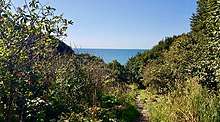
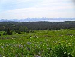 View from Diamond Ridge on the Homestead Trail, showing Kachemak Bay and the Kenai Mountains | |
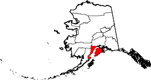
 Diamond Ridge, Alaska Location within the state of Alaska | |
| Coordinates: 59°39′55″N 151°34′15″W / 59.66528°N 151.57083°WCoordinates: 59°39′55″N 151°34′15″W / 59.66528°N 151.57083°W | |
| Country | United States |
| State | Alaska |
| Borough | Kenai Peninsula |
| Government | |
| • Borough mayor | Mike Navarre[1] |
| • State senator | Gary Stevens (R) |
| • State rep. | Paul Seaton (R) |
| Area | |
| • Total | 47.7 sq mi (123.5 km2) |
| • Land | 47.6 sq mi (123.4 km2) |
| • Water | 0 sq mi (0.1 km2) |
| Elevation | 1,060 ft (323 m) |
| Population (2010) | |
| • Total | 1,156 |
| Time zone | UTC-9 (Alaska (AKST)) |
| • Summer (DST) | UTC-8 (AKDT) |
| Area code(s) | 907 |
| FIPS code | 02-18925 |
| GNIS feature ID | 1865549 |
Diamond Ridge is a census-designated place (CDP) just outside Homer in Kenai Peninsula Borough, Alaska, United States. At the 2010 census the population was 1,156, down from 1,802 in 2000.
Geography
Diamond Ridge is located at 59°39′55″N 151°34′15″W / 59.66528°N 151.57083°W (59.665391, -151.570826).[2]
According to the United States Census Bureau, the CDP has a total area of 47.7 square miles (124 km2), of which, 47.6 square miles (123 km2) of it is land and 0.04 square miles (0.10 km2) of it (0.08%) is water. The main access is via Diamond Ridge Road, which runs across the top of the 5 miles (8.0 km) long ridge[3] and connects to feeders roads on either side.
Demographics
| Historical population | |||
|---|---|---|---|
| Census | Pop. | %± | |
| 2000 | 1,802 | — | |
| 2010 | 1,156 | −35.8% | |
| U.S. Decennial Census[4] | |||
Diamond Ridge first appeared on the 2000 U.S. Census as a census-designated place (CDP).
As of the census[5] of 2000, there were 1,802 people, 683 households, and 471 families residing in the CDP. The population density was 37.8 people per square mile (14.6/km²). There were 850 housing units at an average density of 17.8/sq mi (6.9/km²). The racial makeup of the CDP was 92.29% White, 0.11% Black or African American, 3.16% Native American, 0.44% Asian, 0.89% from other races, and 3.11% from two or more races. 2.11% of the population were Hispanic or Latino of any race.
There were 683 households out of which 38.9% had children under the age of 18 living with them, 60.0% were married couples living together, 5.7% had a female householder with no husband present, and 31.0% were non-families. 24.0% of all households were made up of individuals and 3.2% had someone living alone who was 65 years of age or older. The average household size was 2.60 and the average family size was 3.15.
In the CDP, the population was spread out with 29.7% under the age of 18, 5.3% from 18 to 24, 30.5% from 25 to 44, 28.6% from 45 to 64, and 5.9% who were 65 years of age or older. The median age was 38 years. For every 100 females, there were 101.6 males. For every 100 females age 18 and over, there were 104.9 males.
The median income for a household in the CDP was $50,977, and the median income for a family was $61,813. Males had a median income of $51,964 versus $26,548 for females. The per capita income for the CDP was $23,864. About 7.9% of families and 7.9% of the population were below the poverty line, including 9.2% of those under age 18 and 4.8% of those age 65 or over.
Parks and trails
Diamond Ridge is home to two park areas with trail systems. One is the Homer Demonstration Forest, a preserve on the slopes just below the actual ridge itself.[6] It contains an arboretum, self-guided nature trails, and is one end of the Homestead Trail which crosses the demonstration forest, climbs up Diamond Ridge and across a deep valley to Crossman Ridge, eventually ending at the Homer Reservoir. In winter months there are extensive groomed trails for cross country skiing, as well as a snowshoe trail.
The other park in the area is the Diamond Creek State Recreation Area. This is a newer unit of Alaska State Parks and has little development. It is day-use only, camping is not permitted and the access road is steep and extremely rough in places, vehicles over 25 feet (7.6 m) are not permitted on the lower part of the road. The road leads to several parking areas for access to both hiking and biking trails. The bike trails are constructed and maintained by a local cycling club. [7]
References
| Wikimedia Commons has media related to Diamond Ridge, Alaska. |
- ↑ 2015 Alaska Municipal Officials Directory. Juneau: Alaska Municipal League. 2015. p. 9.
- ↑ "US Gazetteer files: 2010, 2000, and 1990". United States Census Bureau. 2011-02-12. Retrieved 2011-04-23.
- ↑ U.S. Geological Survey Geographic Names Information System: Diamond Ridge, Alaska
- ↑ "U.S. Decennial Census". Census.gov. Retrieved June 6, 2013.
- ↑ "American FactFinder". United States Census Bureau. Archived from the original on 2013-09-11. Retrieved 2008-01-31.
- ↑ Homer Demonstration Forest, Homer Soil and Water Conservation District
- ↑ Press release for Trails Day 2018, Alaska Department of Natural Resources