Dhofar Governorate
| Dhofar Governorate محافظة ظفار | |
|---|---|
| Governorate | |
| Muḥāfaẓat Ẓufār | |
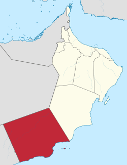 Map of Oman with the Dhofar Governorate highlighted | |
| Capital | Salalah |
| Wilayat (districts) | 10 |
| Government | |
| • Governor | Mohammad bin Sultan Al-Busaidi |
| • Deputy | Abdullah bin Aqeel Al-Ibrahim |
| Area | |
| • Total | 99,300 km2 (38,300 sq mi) |
| Population (2016) | |
| • Total | 458,734 |
| • Density | 4.6/km2 (12/sq mi) |
| ISO 3166-2 | 211 |
| Website | http://www.dm.gov.om |
The Dhofar Governorate (Arabic: محافظة ظفار, Muḥāfaẓat Ẓufār) is the largest of the eleven Governorates in the Sultanate of Oman in terms of area. It lies in Southern Oman, on the eastern border with Yemen. It is a rather mountainous area that covers 99,300 km2 (38,300 sq mi) and has a population of 249,729 as of the 2010 census.[1] The largest city, as well as capital of the Governorate, is Salalah. Historically the region was the chief source of frankincense in the world. The local variety of Arabic is Dhofari Arabic, which is quite distinct from that of the rest of Oman and from Yemen.
People
While Arabic speakers from the dominant culture of Oman have come to live in the province, especially the larger cities and towns, Dhofar has been the traditional homeland of many tribespeople speaking Modern South Arabian languages. One of the languages most commonly spoken by the al-Hakli (Qara), al-Shahri, al-Barami, al-Mashaiki and al-Bathari mountain tribes is the Shehri language (called Jibbali "Mountainous"). The Yemeni language Mehri is somewhat linked to Jeballi. Other indigenous groups speaking smaller languages such as Bat'hari live in the coastal towns of Shuwaymiya and Sharbithat. The Harasis, speaking Harsusi, number 1–2000 and live in Jiddat al-Harasis. Also in the region are the Arab-Somali tribe Darod as a large minority.
Dhofar's area geographically consists of coastal, mountainous, flat, and desert areas. Generally the people of Dhofar can be identified as either Jeballi (living in the mountains, or from the mountains), Badawi (living in the desert, or from the desert), or Hadhari (living in the cities or settlements).
Climate
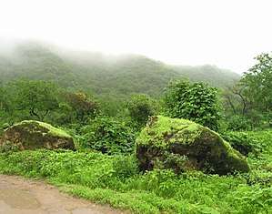

Dhofar has a subtropical climate. Dhofar and a small portion of the northern tip of Yemen are directly exposed to the South East monsoon from mid-June to mid-September;[2] this is known as the Khareef. As a result, it has a lush green climate during the monsoon season and for some time after until the vegetation loses its moisture. Dhofar's temporarily wet climate contrasts sharply with the neighboring barren Empty Quarter Desert. The Salalah plain was once a well cultivated area with a sophisticated irrigation system.
Prehistory
At Aybut Al Auwal (‘‘First Aybut’’) in Wadi Aybut (west-central Nejd) a site was discovered in 2011 containing more than 100 surface scatters of stone tools belonging to a regionally specific lithic industry, the late Nubian Complex, known previously only from Northeast Africa. Two optically stimulated luminescence age estimates place the Arabian Nubian Complex at 106,000 years old. This provides evidence for a distinct Middle Stone Age technocomplex in southern Arabia around the earlier part of the Marine Isotope Stage 5.[3][4]
History
Prior to Omani rule, a portion of Dhofar was partially part of the sultanate of Kathiri and later mostly controlled by tribes of al-Hakli (Qara), thus given the name Qara Mountain Range. It is thought that the al-Shahri were the original inhabitants of Dhofar.
Dhofar was a major exporter of frankincense in ancient times, with some of it being traded as far as China.[5]
During World War I it was fertile enough to produce food and grain to supply a large proportion of the requirement of the British Army fighting in Mesopotamia.
A counter-insurgency campaign—the Omani Civil War (1963-76)—was fought here by the Sultan of Oman's Armed Forces in 1965–1975 against guerrilla fighters of the nationalist Dhofar Liberation Front and later the Marxist Popular Front for the Liberation of Oman and the Persian Gulf (PFLOAG), supported by Communist South Yemen after that territory's independence and several other socialist states, including East Germany. It aimed to depose the Sultan. The Sultan's forces, assisted by the United Kingdom, Iran, and support from loaned officers and doctors from Pakistan and India,[6] prevailed, and once the campaign was declared over in December 1975, the active remainder of PFLOAG forces surrendered.
In Mormonism
In the culture of The Church of Jesus Christ of Latter-day Saints, the coasts of Dhofar are considered the most likely location of the Book of Mormon land of Bountiful, from which the nomadic family of Lehi sailed in a ship constructed by his son Nephi, to the New World.[7]
Culture and landmarks

Dhofar has a tribal community, and is home to many ancient tribes. The tribes include, Al-Hakli(Qara), Hashimi, Al-Yafei, Al-Mashaikhi, Al-Shahri, Al-Mahri, Al-Bat'hari, Darood, and Al-Barami. It also houses many expatriates. Still, Dhofar is not a rural region but, in fact, has a combination of cultures. It is a mixture of traditional Omani heritage and an international way of living.
The city of Salalah acts as the regions capital. It has an International Airport, one of the largest seaports in the Middle East, several resorts including Marriott and Crowne Plaza, well-kept streets, international retail chain outlets, more than five 3D cinemas under construction, a university, colleges and schools (both English and Arabic medium). But the main attraction of the region is the natural beauty that has been preserved despite its industries. Dhofar has been praised for its scenic beauty from time immemorial. The Dhofar region is rich in meteorites.
The Burj-al-Nadha Clock-tower is a popular landmark and is featured in the Dhofar Municipality coat of arms.
Districts
Dhofar Governorate ("muhafazah" or governorate) (see provinces of Oman) consists of ten districts, with Al-Mazyona, named in honor of Qaboos bin Said al Said's mother Mazoon al-Mashani, being the newest after it was declared detached from Rakhyut district.
The following are the ten districts (Wilayats: often translated "provinces" elsewhere) of Dhofar:
See also
.jpg)
References
- ↑ Our Correspondent 9:34 am (June 12, 2011). "Oman's population is 2,773,479: Census". Muscat Daily. Archived from the original on December 23, 2012. Retrieved October 19, 2012.
- ↑ "World Weather Information Service - Salalah". Worldweather.wmo.int. October 5, 2006. Archived from the original on July 22, 2014. Retrieved October 19, 2012.
- ↑ The Nubian Complex of Dhofar, Oman: An African Middle Stone Age Industry in Southern Arabia
- ↑ The Nubian Complex in southern Arabia, 106 thousand years ago
- ↑ Ralph Kauz (2010). Ralph Kauz, ed. Aspects of the Maritime Silk Road: From the Persian Gulf to the East China Sea. Volume 10 of East Asian Economic and Socio-cultural Studies - East Asian Maritime History. Otto Harrassowitz Verlag. p. 130. ISBN 3-447-06103-0. Retrieved December 26, 2011.
- ↑ In the service of the Sultan - Ian Gardiner
- ↑ Hilton, Lynn M; Hilton, Hope A (1996). Discovering Lehi : New evidence of Lehi and Nephi in Arabia. Springville, UT: Cedar Fort, Inc. ISBN 1555172768.
External links
| Wikimedia Commons has media related to Dhofar. |
| Wikivoyage has a travel guide for Dhofar. |
Places adjacent to Dhofar Governorate | ||||||||||
|---|---|---|---|---|---|---|---|---|---|---|
| ||||||||||
| Governorates | ||
|---|---|---|
| Former regions (abolished in 2011): | ||