Derby, Connecticut
| Derby, Connecticut | |||
|---|---|---|---|
| City | |||
 Annual fireworks display from the Derby-Shelton Bridge | |||
| |||
| Motto(s): "Connecticut's Smallest City"[1] | |||
 Location in New Haven County, Connecticut | |||
 Derby, Connecticut Location in the Unites States | |||
| Coordinates: 41°19′36″N 73°04′56″W / 41.32667°N 73.08222°WCoordinates: 41°19′36″N 73°04′56″W / 41.32667°N 73.08222°W | |||
| Country |
| ||
| State |
| ||
| County | New Haven | ||
| Region | Lower Naugatuck Valley | ||
| NECTA | Bridgeport-Stamford | ||
| Named | 1675 | ||
| Incorporated (town) | 1775 | ||
| Incorporated (city) | 1893 | ||
| Government | |||
| • Type | Mayor-Board of Aldermen | ||
| • Mayor | Richard Dziekan (R) | ||
| Area | |||
| • Total | 5.4 sq mi (14.0 km2) | ||
| • Land | 5.0 sq mi (12.9 km2) | ||
| • Water | 0.4 sq mi (1.0 km2) | ||
| Elevation | 102 ft (31 m) | ||
| Population (2010) | |||
| • Total | 12,902 | ||
| • Estimate (2016)[2] | 12,755 | ||
| • Density | 2,400/sq mi (920/km2) | ||
| Time zone | UTC-5 (Eastern) | ||
| • Summer (DST) | UTC-4 (Eastern) | ||
| ZIP code | 06418 | ||
| Area code(s) | 203 | ||
| FIPS code | 09-19480 | ||
| GNIS feature ID | 0206671 | ||
| Website |
www | ||


Derby ('dər-bē) is a city in New Haven County, Connecticut, United States, approximately 8 miles west-northwest of New Haven, Connecticut. Derby is located in southwest Connecticut at the confluence of the Housatonic and Naugatuck Rivers. It borders the cities of Ansonia to the north and Shelton to the southwest, and the towns of Orange to the south, Seymour to the northwest, and Woodbridge to the east. The population was 12,903 at the 2010 census. It is the smallest consolidated city in Connecticut by area and population.[3]
Derby was settled in 1642 as an Indian trading post under the name Paugasset. It was named after Derby, England, in 1675.[4][5] It included what is now Ansonia, Seymour, and parts of Oxford and Beacon Falls. Derby is home to the first trolley system in New England and the first electric locomotive in U.S. history to be built and successfully used commercially for hauling freight. The locomotive, built in 1888 is still kept in running condition by the Shore Line Trolley Museum.[6][7]
History
Derby was settled in 1642 as an Indian trading post under the name Paugasset by John Wakeman of New Haven, though fur traders had been in the area before and Native Americans had lived there for centuries. In 1651, the first year-round houses were completed, at that time the New Haven Colony had recognized Paugasset as a town. The residents of the town of Milford protested Paugassets' recognition as an independent town and, as a result, the order was rescinded and Paugasset returned to the Milford jurisdiction. In 1675, the former plantation of Paugasset was admitted as the township of Derby by the state legislature, named after Derby, England.[8] Derby was incorporated on May 13, 1775.[9]
In 1836, The Colman Brothers began The Birmingham Iron Foundry on the corner of Main Street and Water Street. It employed between 100-125 and was one of the many manufacturing businesses thriving in the city in the 1800s. In 1927, the company merged with Farrel Corporation of nearby Ansonia and renamed Farrel-Birmingham Corporation. The Derby Facility closed and was razed in 2000 to make way for a Home Depot. The Ansonia division is still in business and opened their new plant in the Fountain Lake Commerce Park in 2017.[10][11]
In the 19th century, both corsets and hoop skirts were manufactured in the city. The Kraus Corset Factory is the oldest major factory building to survive from Derby's corset manufacturing period. It was built by Sidney A. Downs, opened in 1879, and expanded in 1910. In 1987 it was added to the National Register of Historic Places. In the 1990s it was converted to apartments and underwent a second addition, a first floor parking garage and three stories of apartments added on the north side along Roosevelt Drive (Connecticut Route 34).[12][13]
In 1872, the Derby Silver Company began production. In 1898, the company became a division of the International Silver Company headquartered in Meriden, CT, but continued making silver with its brand name until 1933.[14][15][16]
Charlton Comics, a comic book publishing company that existed from 1944 to 1986, was based in town.
Geography
According to the United States Census Bureau, the town has a total area of 5.4 square miles (8.7 km2), of which, 5.0 square miles (13 km2) of it is land and 0.4 square miles (1.0 km2) of it (7.41%) is water. The city is home to the 417 acres (0.652 sq mi) Osbornedale State Park. Derby is divided into two main sections by the Naugatuck River: East Derby and Derby Center (Birmingham). The center of Derby is approximately 66 miles (106 km) from New York City.
Climate
The climate in this area is characterized by hot, humid summers and generally mild to cool winters. According to the Köppen Climate Classification system, Derby has a humid subtropical climate, abbreviated "Cfa" on climate maps. January is on average the coolest month and July is on average the warmest month.[17]
| Climate data for Derby, Connecticut | |||||||||||||
|---|---|---|---|---|---|---|---|---|---|---|---|---|---|
| Month | Jan | Feb | Mar | Apr | May | Jun | Jul | Aug | Sep | Oct | Nov | Dec | Year |
| Record high °F (°C) | 65 (18) |
69 (21) |
84 (29) |
93 (34) |
95 (35) |
98 (37) |
104 (40) |
101 (38) |
98 (37) |
90 (32) |
79 (26) |
71 (22) |
104 (40) |
| Average high °F (°C) | 35 (2) |
37 (3) |
46 (8) |
57 (14) |
68 (20) |
77 (25) |
83 (28) |
81 (27) |
73 (23) |
62 (17) |
50 (10) |
39 (4) |
59 (15) |
| Average low °F (°C) | 17 (−8) |
19 (−7) |
28 (−2) |
37 (3) |
47 (8) |
56 (13) |
62 (17) |
60 (16) |
52 (11) |
41 (5) |
32 (0) |
23 (−5) |
40 (4) |
| Record low °F (°C) | −17 (−27) |
−24 (−31) |
−11 (−24) |
11 (−12) |
26 (−3) |
32 (0) |
38 (3) |
36 (2) |
26 (−3) |
16 (−9) |
1 (−17) |
−18 (−28) |
−24 (−31) |
| Average precipitation inches (mm) | 4.59 (116.6) |
3.37 (85.6) |
4.65 (118.1) |
4.63 (117.6) |
4.70 (119.4) |
4.44 (112.8) |
4.28 (108.7) |
4.50 (114.3) |
4.66 (118.4) |
4.54 (115.3) |
4.47 (113.5) |
4.03 (102.4) |
52.86 (1,342.6) |
| Average snowfall inches (cm) | 7.9 (20.1) |
7.8 (19.8) |
5.0 (12.7) |
1.1 (2.8) |
0 (0) |
0 (0) |
0 (0) |
0 (0) |
0 (0) |
0 (0) |
0 (0) |
0.7 (1.8) |
5.6 (14.2) |
| Source #1: Weather Channel[18] | |||||||||||||
| Source #2: Intellicast[19] | |||||||||||||

Demographics
| Historical population | |||
|---|---|---|---|
| Census | Pop. | %± | |
| 1790 | 2,994 | — | |
| 1800 | 1,878 | −37.3% | |
| 1810 | 2,051 | 9.2% | |
| 1820 | 2,088 | 1.8% | |
| 1830 | 2,253 | 7.9% | |
| 1840 | 2,851 | 26.5% | |
| 1850 | 3,824 | 34.1% | |
| 1860 | 5,443 | 42.3% | |
| 1870 | 8,020 | 47.3% | |
| 1880 | 11,650 | 45.3% | |
| 1890 | 5,969 | −48.8% | |
| 1900 | 7,930 | 32.9% | |
| 1910 | 8,991 | 13.4% | |
| 1920 | 11,238 | 25.0% | |
| 1930 | 10,788 | −4.0% | |
| 1940 | 10,287 | −4.6% | |
| 1950 | 10,259 | −0.3% | |
| 1960 | 12,132 | 18.3% | |
| 1970 | 12,599 | 3.8% | |
| 1980 | 12,346 | −2.0% | |
| 1990 | 12,199 | −1.2% | |
| 2000 | 12,391 | 1.6% | |
| 2010 | 12,902 | 4.1% | |
| Est. 2016 | 12,755 | [2] | −1.1% |
| U.S. Decennial Census[20] | |||
As of the census[21] of 2010, there were 12,902 people, 5,388 households, and 3,241 families residing in the town. The population density was 2,563 people per square mile. There were 5,849 housing units at an average density of 1,169.8 per square mile. The racial makeup of the town was 82.08% White, 7.06% Black or African American, 0.2% Native American, 2.60% Asian, 0.00% Pacific Islander, 4.2% from other races, and 2.6% from two or more races. Hispanic or Latino of any race were 14.2% of the population.
There were 5,388 households out of which 28.9% had children under the age of 18 living with them, 39.6% were married couples living together, 15.3% had a female householder with no husband present, and 39.8% were non-families. 32.8% of all households were made up of individuals and 12.3% had someone living alone who was 65 years of age or older. The average household size was 2.35 and the average family size was 3.01.
In the town, the population was spread out with 23% under the age of 19, 6.2% from 20 to 24, 27.8% from 25 to 44, 27.3% from 45 to 64, and 15.7% who were 65 years of age or older. The median age was 40 years.
The median income for a household in the town was $32,438, and the median income for a family was $57,790. The per capita income for the town was $32,438.[22] 12.7% of the population is below the poverty line.[23]
| Voter registration and party enrollment as of November 1, 2016[24] | |||||
|---|---|---|---|---|---|
| Party | Active voters | Inactive voters | Total voters | Percentage | |
| Democratic | 2,446 | 337 | 2,783 | 36.82% | |
| Republican | 1,104 | 119 | 1,223 | 16.18% | |
| Unaffiliated | 2,809 | 660 | 3,469 | 45.90% | |
| Minor Parties | 80 | 2 | 82 | 1.08% | |
| Total | 6,439 | 1,118 | 7,557 | 100% | |
Polish immigration
Polish immigrants have left a large mark on the demographics of the town, with 18% of all residents claiming Polish as their ethnicity and 2% as having been born in Poland.[25] Due to this large population, the town features several Polish shops, restaurants, and clubs.[26] Saint Michael's the Archangel Parish, a Roman Catholic church serves mass in Polish as well as English.
Economics
Mill Rate
Notable Businesses
Derby Silver Company (1872-1933) - International silver company based in Derby.
Charlton Comics (1944-1986) - Comic book company based in Derby.
Griffin Hospital (1909–Present) - Community hospital in Derby.
BADSONS Beer Company (2017–Present) - Brewery in Derby.
Dew Drop Inn (2008–Present) Voted Connecticut Magazine's best wings in Connecticut 2017-18.[28]
THC - The Hops Company (2015–Present) Voted Connecticut Magazine's best Beer Garden in Connecticut 2017 & Best Beer Bar in Connecticut 2017-18.[28]
Curved Glass Distributors (1970–Present) - Glass manufacturer based in Derby.
Aqua Vim (Future) - Aquarium manufacturer undergoing move from Queens, New York to Derby.[29]
Education
There are five public schools and one private school in Derby, Connecticut. As of the 2017-2018 school year there were 1,386 students enrolled in public schools[30] and 159 students enrolled in private school.[31] The total number of students enrolled in public & private schools is 1,545.
| School Name | Grades | Address | Type | Neighborhood |
|---|---|---|---|---|
| St. Mary-St. Michael School | Pre-K - 8 | 14 Seymour Avenue | Private-Catholic | West Derby (Downtown) |
| Little Raiders University | Pre-K | 75 Chatfield Street | Public | West Derby (Downtown) |
| Bradley Elementary School | K-5 | 155 David Humphrey Road | Public | East Derby |
| Irving School | K-5 | 9 Garden Place | Public | West Derby (Downtown) |
| Derby Middle School | 6-8 | 73 Chatfield Street | Public | West Derby (Downtown) |
| Derby High School | 9-12 | 75 Chatfield Street | Public | West Derby (Downtown) |
On January 12, 2018, a former Extended Care Health Facility was sold to Apex International Education Partners (AIEP) to be converted into dormitories for international high school students attending private schools in the area.[32] The dormitory was opened on September 19, 2018 and at full capacity it can accommodate 110 students and 10-12 employees.[33]
Crime
According to USA.com crime statistics, Derby has the 14th highest crime rate per capita in Connecticut of the 89 reporting cities.[34] In 2016, Derby had 6 rapes, 21 robberies, 12 aggravated assaults, 65 burglaries, 195 larcenies, and 38 motor vehicle thefts.[35]
Criminal cases are prosecuted by The State's Attorney's Office and Derby also has a State of Connecticut Superior Courthouse on Elizabeth Street adjacent to the Derby Green.
Notable Crimes
The Derby Poisoner
Lydia Sherman was a female serial killer active from 1864-1871 in New York and Derby, poisoning and killing three husbands and eight children. She is known to have killed one husband and two children in Derby in 1867. She was nicknamed "The Derby Poisoner" for using arsenic to kill her victims.[36] Sherman was convicted of second-degree murder and sentenced to life in prison in 1872, she died in 1878 in prison.[37]
Ferrera Family Triple Homicide
On August 12, 1989, three members of the Ferrera Family on Emmitt Ave were stabbed to death by Derek Roseboro. Their bodies were discovered by a family member late that same evening, the suspect, Roseboro was found a short time later in New Haven with a self-inflicted stab wound and confessed. Roseboro was sentenced to 130 years in prison in 1992 and spared the death penalty.[38]
Public Safety
Hospitals
Derby is home to Griffin Hospital, a 160-bed acute care facility located at 130 Division Street in Derby. Nearby trauma centers include Yale–New Haven Hospital, Hospital of St. Raphael, Bridgeport Hospital, and Saint Vincent's Hospital
Law Enforcement
Derby Police Department
The Derby Police Department provides police services to the residents of the city and is located at 125 Water Street. As of 2016 the department had 36 sworn police officers.[39] The current Chief of Police is Gerald D. Narowski.
State Police Agencies
- Connecticut State Police Troop I - Patrols nearly 2 miles of Connecticut Route 8 which runs through the city.
- Connecticut Department of Energy and Environmental Protection/EnCon Police - Primary police service for 417 acres of Osbornedale State Park & The Osbournedale Homestead
Lake Housatonic Authority
The Lake Housatonic Authority acts an agent for member towns along Lake Housatonic in regards to patrolling and ensuring safe operation of watercraft. Patrol Officers are trained by the Connecticut Police Academy in Meriden, Connecticut. Patrol Officers are also trained in first aid, CPR, boating law, and safety regulations.[40]
Derby Fire Department
The City of Derby is served by volunteer firefighters in the Derby Fire Department (DFD). The DFD consists of four all-volunteer fire companies (Hotchkiss Hose Co. # 1, Storm Engine Co. # 2, East End Hose Co. # 3, and Paugassett Hook & Ladder Co. # 4) operating out of four fire stations located throughout the city. Each all-volunteer fire company is commanded by a captain and two lieutenants, who in turn are commanded by three department assistant chiefs. The assistant chiefs in turn report to the Chief of Department, Kurt Kemmesis., who reports to the Fire Commissioner, Mike Kelleher.
History
Organized fire protection in Derby is traced back to the organization of the Derby Fire Engine Company which existed from 1830 to a period during the early 1850s. This was Derby's first organized fire company, with its quarters located originally in the area of Gilbert and Highs Streets, then called Derby Landing. This company operated an older style "goose-neck" fire engine that was outdated at the time. The fire engine was pumped by moving the handles back and forth thus forcing the water through the pipe and nozzle attached to the unit. People had to dump water into the fire engine by using buckets instead of putting a hose into or hooking up to a water source. In early 1840s, the company moved up Derby Avenue to the area approximately across from where St. Michael's Church now stands (the present east-bound lanes of Route 34). As the center of the town shifted from the east side to what is now downtown, interest in the company waned and thus was disbanded.
Hotchkiss Hose Co. 1
In 1837, residents in the village of Birmingham (today's present downtown) petitioned for their own fire company to protect their interests. Upon receiving a state charter the Birmingham Fire Company was established on June 7, 1837. This company is the oldest firefighting organization in the city now known as the Hotchkiss Hose Company No. 1. The company was first located in the area of Third and Minerva Streets then moved in the 1840 to Caroline Street to a location near the crest of the "cobblestone hill" portion of the street. The company moved again into new quarters several years later to the property located on Caroline Street across from Third Street. In 1872 the company changed its name to the Hotchkiss Hose Company No. 1 in honor of one of their original members Lewis Hotchkiss. In the early 1920s the old wood framed firehouse was removed from the property and the present building that houses the arts center was erected for the Hotchkiss Hose where the company remained until moving to their present location on David Humphreys Road in 1971.
Storm Engine Co. 2 & Storm Engine Co. Ambulance Corps.
The Storm Engine Company No. 2 was organized in 1851 when Birmingham was a borough in the town of Derby and was formally incorporated in 1853. First quartered on Elizabeth Street in the area of the Derby Green, the company now operates from its firehouse located on Oliva Street since the 1950s. The Storm Engine Company has continued holding an annual firemen's formal ball since its inception which now takes place Thanksgiving weekend. In 1949 seeing the need for an ambulance service in Derby, several members of the Storm Engine Company led by Edward Cotter established the Storm Engine Company Ambulance Corps, which continues today to provide medical, rescue and hazardous materials mitigation services.
East End Hose Co. 3
In 1950, residents in the "East End" section of Derby's east side organized a new fire company to protect that area of the city. The unit organized independently from the city and adopted the name East End Hose Company No. 3. The company originally operated an old fire engine that was first used by the Storm Engine Company and was quartered at various locations. In 1955 the company moved into its present quarters on Derby-Milford Road, which was erected by the company's membership. The company remained independent from the city up until 1975 when the company was included and incorporated as part of the Derby Fire Department.
Paugassett Hook & Ladder Co. 4
The Paugassett Hook & Ladder Company No 4 was organized in 1903 originally as a hose company and originally named the Paugassett Hose Company No. 4. This company is named in honor of the Paugassett Native American tribe that once called Derby home. The company organized in what was known as the "Hotchkiss Hose Reserve", a unit of the Hotchkiss Hose that kept a hose cart on the east side of town to help protect it. When the Paugassetts organized, it was the first fully organized fire company to exist on Derby's east side since the disbanding of the old Derby Fire Engine Company in the 1850s. The company's first firehouse stood where the present firehouse now stands on Derby Avenue (Route 34). Around 1915 - 1916 the Paugassett Hose was given a motorized ladder truck after the disbanding of Derby's former hook and ladder company. It was at this time the company became known as the Paugassett Hook & Ladder Company No. 4.
Disbanded Fire Companies
Besides the Derby Fire Engine Company, two other fire companies also existed before being disbanded. Around 1856 a unit known as the Pequot Fire Company was organized and existed for a short period of time. In 1861 this company ended up disbanding when a good majority of its members signed up to fight in the American Civil War to quell the southern rebellion. After the war, the members reorganized as a social club but never again acted as a fire fighting unit. The other fire company was known as the R. M. Bassett Hook & Ladder Company. This unit was organized in the Borough of Birmingham in 1874 and was named in honor of manufacturer Royal M. Bassett. The company was first quartered on Main Street until the completion of the Sterling Opera House. The company took up quarters on the old Fourth Street side of the Opera House which was later utilized by the Derby Police Department. The company was removed from their Opera House quarters around 1915 / 1916 under some sort of controversy though it seems the true reason is lost to history. With no home of their own the Bassett Hook & Ladder Company was disbanded and the "truck company" duties of the department were transferred over to the Paugassetts.[41][42]
Below is a list of current fire apparatus for the City of Derby.
| Fire Company | Engine | Ladder | Ambulance | Special Unit | Address | Neighborhood |
|---|---|---|---|---|---|---|
| Hotchkiss Hose Co. #1 | Engine 13, Engine 14 | 200 David Humphrey Rd. | East Derby | |||
| Storm Engine Co. #2 | Engine 11, Engine 12 | 4-Kilo-9 (FD-9)
4-Kilo-10 (FD-10) |
Rescue 18, HAZ-MAT 19, HAZ-MAT 2 (State of CT),
Marine 1, Marine 2, Dive Unit, Emergency 1 (Fly-Car) |
151 Olivia St. | Downtown | |
| East End Hose Co. #3 | Engine 16 | Utility 17 | 10 Derby-Milford Rd. | East Derby | ||
| Paugassett Hook & Ladder Co. # 4 | Truck 15 | Brush 4, Tac. 51(Gator) | 57 Derby Ave. | East Derby |
Parks & Recreation
Derby Greenway
The Derby Greenway is a 2.05 mile long multipurpose trail located on the west side of Derby along the Naugatuck and Housatonic Rivers.[43] The Greenway is part of the Naugatuck River Greenway Trail System, a proposed 44 mile multipurpose trail that follows the Naugatuck River from Torrington to Derby.[44] The Derby section of the Naugatuck River Greenway System is the busiest multipurpose trail in Connecticut with 302,550 trips counted in 2017.[45]


PFC Frank P. Witek Memorial Park
The Frank P. Witek Memorial Park is a 144-acre park on the east side of the city dedicated to Metal of Honor Recipient Frank P. Witek, who was born in Derby on December 10, 1921. The property, formerly a reservoir, dates back to 1859 when the burgeoning Borough of Birmingham (present day Downtown Derby)[46] needed a stable water supply. The newly established Birmingham Water Company bought the area which was mostly meadows and farmland to create two reservoirs by damming area brooks. The land was purchased by the city in 1997 and dedicated on May 29, 1999. In addition to the 2 ponds (former reservoirs), there are hiking/walking trails and 2 soccer fields the city built in 2006.[47]
Landmarks & Monuments
National Register of Historic Places
- Birmingham Green Historic District - A total of 10 buildings, 3 of which are churches, and 4 monuments encompass the district. It was listed on the National Register of Historic Places in 2000 as a good example of privately organized 19th century urban planning.[48]
- John I. Howe House - Home of pin manufacturing pioneer. Built in 1845, It was built for John Ireland Howe of the Howe Pin Company. In 1838, Howe moved his business from New York to Derby. The Howe House was added to the National Register of Historic Places in 1989.[49]
- Kraus Corset Factory - Historic corset manufacturer, now the Sterling Rowe Apartment House on the corner of Roosevelt Drive and Third Street.
- Osbornedale Homestead - Historic nineteenth-century farmhouse. Today, the state operates it as the Osbornedale Homestead Museum. The land surrounding it is Osbornedale State Park.[50]
- Sterling Opera House - Amelia Earhart, John L. Sullivan, Harry Houdini, George Burns, Lionel Barrymore, Ethel Barrymore, Red Skelton, and John Philip Sousa appeared on this stage. The Sterling Opera House became the first building in Connecticut to be added to the National Register of Historic Places in 1968.[51]
- Harcourt Wood Memorial Library - Built in 1902 with Ansonia marble, the library was founded as a free reading room in 1868. The land was provided by the Sarah Riggs Humphreys Chapter of the Daughters of the American Revolution, on the condition that the building would always have a room the chapter could use.[52]
Landmarks
National Humane Alliance Fountain

The city has resurrected its National Humane Alliance fountain – a century-old granite structure with lion-head spigots—as part of a gateway entrance plaza at the Division Street entrance to the Derby Greenway. The fountain was given to the City in 1906 by the National Humane Alliance and erected at the intersection of Seymour and Atwater Avenues. The water was first turned on on June 1, 1906. Years later it was moved to Founders Commons when traffic patterns made its original location a problem. It fell into disrepair and was not used as a fountain while on Founders Commons. When the Derby Greenway was built, the fountain was moved to its new location on June 22, 2006, fully restored with new plumbing and new lions heads and formally dedicated with the surrounding Derby Hall of Fame Plaza on September 1, 2007.[53] The fountain has three levels, the top level contains spigots in the shape of lion's heads for humans, below is a large circular bowl for horses, and at the base are smaller bowls for dogs and cats.
Civil War Monument

In 1875, the Elisha S. Kellogg Post, of the Grand Party of the Republic raised $1,475 to erect a statue to honor the soldiers of Derby and Huntington (now Shelton) who served in the Union forces. In 1878, an unknown person made a donation of $1,500 for the statue base which made it possible to proceed with erecting the statue. The base of the monument was dedicated July 4, 1877. Several years later, $3,200 was pledged for a remodel of the existing base and the addition of an upper base and a 7 ft bronze statue, bringing the total height of the monument to 21 ft 4in. The remodel and addition was constructed by Maurice J. Power of New York City, the sculptor of the bronze statue is unknown. The dedication of the remodel/addition was held on July 4, 1883 and was attended by approximately 8,000 people.[54] The monument was restored in 2018 for a cost of $75,000.[55]
Notable Events
River Restaurant Explosion
On December 6, 1985 at approximately 3:45pm EST, a three-story brick building, located at 268 Main St, Derby, collapsed following a natural gas explosion killing 6 people and injuring dozens. Natural gas had seeped into the sewer line following construction in the area, the River Restaurant, located on the main level of the building had 18 customers and employees inside when the explosion occurred. Residents and businesses within a 10 block radius were evacuated as a precaution while firefighters worked to find those trapped in the debris. The Connecticut Fire Marshals Office, Connecticut State Police, and The National Transportation Safety Board investigated and found a crack in a four-inch cast iron pipe near the explosion site. Connecticut's "Call Before You Dig" program is a direct response to this incident.[56][57]
Flood of 1955
August 10–12 of 1955 brought heavy rain to the east coast from Hurricane Connie saturating the ground. A week later when Hurricane Diane passed through, the rain water had nowhere to go. As a result, the Housatonic and Naugatuck Rivers over flowed their banks and devastated the Housatonic and Naugatuck River Valley areas.[58] The crest of the Naugatuck River reached 25.70 ft above flood stage, the highest in recorded history, which it still maintains to this day.[59] Low-lying cities in the area, such as Derby, Shelton, Ansonia, Seymour, Beacon Falls and Oxford all suffered impacts from the flood. In total, 87 people were killed and an estimated $200 million(1955) or $1.8 billion(2018) in damage was reported.[60]
Infrastructure
Rail
The city has a Metro-North railroad station called Derby – Shelton. The station is located at 1 Main Street and serves the residents of Derby & Shelton, Connecticut. Derby-Shelton is the last regular stop on the Waterbury Branch before it joins the Northeast Corridor. The station is 69.5 miles to Grand Central Terminal, with travel time there being an average of one hour, 54 minutes depending on transfer time at Bridgeport. Travel time to New Haven is an average of one hour, two minutes depending on transfer time.[61]
Bus
Connecticut Transit - Route F6
Greater Bridgeport Transit Authority - Routes 15 & 23
Valley Transit - Dial-A-Ride
Both bus routes meet at the Derby–Shelton (Metro-North station), the Valley Transit facility is next to the train station on adjoining property.
Airports
Local
Waterbury–Oxford Airport (13 mi)
Regional
Tweed New Haven Airport (15 mi)
International
Bradley International Airport (58 mi)
Places of Worship
Media
Current
The Valley Independent Sentinel, an online-only, non-profit news site, launched in June 2009. It has an office in Ansonia. Its editor lives in Derby.
The Valley Gazette, a weekly, also covers Derby, as does The Connecticut Post and The New Haven Register.
Historical
Derby was the location of Charlton Press, Inc. The company remains unique in the publishing industry in that every phase of production (editorial, printing, distribution) took place under one roof. The Charlton Building housed three sister companies: Charlton Press, Charlton Publications, and Capitol Distribution. The company is best known for its extensive Charlton Comics division which produced dozens of comic book titles from 1946 to 1985.
Derby was also the home of Bruce-Royal Publishing Corporation located on Division Street. The company published men's magazines such as Escapade (1955-1968), Gentleman (c. 1964-1966), and Play-Things (1964).

Notable People
- Samuel George Andrews, (1796–1863), born in Derby, United States congressman from New York[62]
- Ebenezer Don Carlos Bassett (1833–1908), the first black American diplomat (appointed in 1869 to Haiti)
- Charles T. Beardsley, Jr. (1861-1937), born in Derby, became noted Bridgeport architect
- Brian Dennehy, film actor, lived in Derby during his early life and was a Boy Scout in Troop 3, based in Derby
- Steve Ditko, co-creator of Spider-Man comics hero
- William Frederick Durand (1859–1958), the first civilian chair of the National Advisory Committee for Aeronautics
- Isaac Hull (1773–1843), commodore in the U.S. Navy; commanded USS Constitution among other ships, and nephew of William Hull
- William Hull (1753–1825), general in the American Revolutionary War, governor of Michigan Territory, and uncle of Isaac Hull
- David Humphreys, American Revolutionary War soldier, public official and entrepreneur
- Orson Hyde (1805–1878), a leader in the Latter Day Saint (Mormon) movement
- Themis Klarides (1965-), Connecticut General Assembly Minority Leader, elected in 1998
- Patrick B. O'Sullivan (1887-1978), CT state senator, US congressman, Superior Court judge, and Chief Justice of the CT Supreme Court
- Nick Pietrosante, NFL fullback for the Detroit Lions, Cleveland Browns and Notre Dame Fighting Irish; born in Derby
- J.R. Romano, Connecticut Republican Party Chairman
- Alan Schlesinger, former Derby mayor and unsuccessful candidate for the U.S. Senate in 2006
- Sheldon Thompson, former Mayor of Buffalo, New York
- Elizabeth Ann Whitney (1800–1882), early Latter Day Saint (Mormon) leader; born in town
- Stephen Whitney (1776-1860), merchant and one of New York's first multi-millionaires
- Frank P. Witek (1921-1944), recipient of the Medal of Honor; born in Derby
- Edward Wooster (1622–1689), "the first permanent settler in Derby"
- Lydia Sherman (1824-1878), female serial killer, murdered 12 people total, 3 in Derby.
Sister Citiy
Plans for the future
The Howe House "will become home of the Lower Naugatuck Valley Industrial Heritage Center; where the Derby Historical Society's extensive collection of Industrial Era artifacts will be properly displayed. Future educational programs will include student hands-on programs that will introduce the Industrial Revolution and the Valley's active role in this period."[63]
See also
References
- ↑ "City of Derby Connecticut". City of Derby Connecticut. Retrieved September 22, 2012.
- 1 2 "Population and Housing Unit Estimates". Retrieved June 9, 2017.
- ↑ "Derby | ConnecticutHistory.org". connecticuthistory.org. Retrieved 2017-04-24.
- ↑ Gannett, Henry (1905). The Origin of Certain Place Names in the United States. Govt. Print. Off. p. 104.
- ↑ The Connecticut Magazine: An Illustrated Monthly. Connecticut Magazine Company. 1903. p. 331.
- ↑ "First Trolly Run 1888". Retrieved September 22, 2018.
- ↑ "Derby Historical Quiz". Retrieved September 22, 2018.
- ↑ "Derby Quick History". Retrieved September 22, 2018.
- ↑ "Derby, Connecticut". City-Data.com. Retrieved September 22, 2012.
- ↑ "Birmingham Iron Foundary". Retrieved September 27, 2018.
- ↑ "Farrel Corporation". Retrieved September 27, 2018.
- ↑ "NRHP Kraus Corset Factory" (PDF). Retrieved September 27, 2018.
- ↑ "Kraus Corset Factory". Retrieved September 27, 2018.
- ↑ (undated). "A Guide to the International Silver Company Records, 1853-1921". UCONN University Libraries, Storrs, CT. Retrieved October 23, 2016.
- ↑ (undated). "The Derby Silver Company". Connecticuthistory.org. Retrieved October 23, 2016.
- ↑ D. Hurd & Co. (1893). "Derby Silver Co." (page 211). In Town and city atlas of the State of Connecticut. Boston, MA. Retrieved October 23, 2016.
- ↑ "Ansonia Koppen Climate Classification". Weatherbase. 2018-01-08.
- ↑ "Derby CT Monthly Info". Weather.com. Retrieved 2018-01-08.
- ↑ "Derby CT Historical Averages=2018-01-08". Intellicast.com.
- ↑ "Census of Population and Housing". Census.gov. Archived from the original on May 12, 2015. Retrieved June 4, 2015.
- ↑ "American FactFinder". United States Census Bureau. Archived from the original on 2013-09-11. Retrieved 2008-01-31.
- ↑ "Derby Home Locator". Retrieved September 22, 2018.
- ↑ "Derby Statistics". Retrieved September 22, 2018.
- ↑ "Registration and Party Enrollment Statistics as of November 01, 2016" (PDF). Connecticut Secretary of State. Retrieved 2017-04-20.
- ↑ Mozdzer, Jodie. (2009-10-08) 'Warsaw' Coming To Ansonia | Valley Independent Sentinel. Valley.newhavenindependent.org. Retrieved on 2013-07-15.
- ↑ Archived November 30, 2010, at the Wayback Machine.
- 1 2 "Mill Rates by Town". Retrieved September 22, 2018.
- 1 2 "2 Derby businesses voted best in the state". New Haven Register. January 5, 2018. Retrieved September 22, 2018.
- ↑ "Big plans in store for Derby Factory". Connecticut Post. February 22, 2018. Retrieved September 22, 2018.
- ↑ "District Detail for Derby Public Schools". www.nces.ed.gov. Retrieved September 17, 2018.
- ↑ "St. Mary-St. Michael School Profile". www.privateschoolreview.com. Retrieved September 17, 2018.
- ↑ "Sale of Marshall Lane Property Finalized". January 12, 2018. Retrieved September 17, 2018.
- ↑ "Marshall Lane Dormitory Opens in Derby". September 19, 2018. Retrieved September 22, 2018.
- ↑ "Connecticut Crime Index City Rank". USA.com. 2018-01-07.
- ↑ "Crime in Connecticut" (PDF). State of Connecticut. 2018-01-07.
- ↑ "Lydia Sherman the Derby Poisoner". Retrieved September 22, 2018.
- ↑ "Lydia Sherman". Retrieved September 22, 2018.
- ↑ "Derby recalls 1989 triple murder" (PDF). New Haven Register. Aug 12, 2014. Retrieved September 22, 2018.
- ↑ "Crime in Connecticut" (PDF). 2018-01-06.
- ↑ "Lake Housatonic Authority". Retrieved September 23, 2018.
- ↑ Derby Fire Department Derby, CT. Derbyctfire.com (2013-02-24). Retrieved on 2013-07-15.
- ↑ About Us. Derbyctfire.com (1935-09-21). Retrieved on 2013-07-15.
- ↑ "Derby Greenway". Retrieved September 22, 2018.
- ↑ "About the Greenway". Retrieved September 22, 2018.
- ↑ "Connecticut Trail Census". Retrieved September 22, 2018.
- ↑ "Documentary History of American Water Works". Retrieved September 22, 2018.
- ↑ "Witek Memorial Park". Retrieved September 22, 2018.
- ↑ https://en.wikipedia.org/wiki/Birmingham_Green_Historic_District
- ↑ https://en.wikipedia.org/wiki/John_I._Howe_House
- ↑ https://en.wikipedia.org/w/index.php?title=Osbornedale&oldid=751892346
- ↑ https://en.wikipedia.org/wiki/Sterling_Opera_House
- ↑ https://en.wikipedia.org/wiki/Harcourt_Wood_Memorial_Library
- ↑ Derby History Quiz - National Humane Alliance Watering Trough. Electronicvalley.org. Retrieved on 2013-07-15.
- ↑ "Connecticut's Civil War Monuments". Retrieved September 20, 2018.
- ↑ "Civil War monument shines in Derby once more". CT Post. July 11, 2018. Retrieved September 20, 2018.
- ↑ "The River Restaurant 25 years later". Valley Independent Sentinel. December 6, 2010. Retrieved September 22, 2018.
- ↑ "6 found dead after Connecticut blast". NY Times. December 8, 1985. Retrieved September 22, 2018.
- ↑ "Flood of 1955". Retrieved September 23, 2018.
- ↑ "Naugatuck River at Beacon Falls". Retrieved September 23, 2018.
- ↑ "Flood of 1955". Retrieved September 23, 2018.
- ↑ "MNR Stations". Retrieved September 18, 2018.
- ↑ Who Was Who in America, Historical Volume, 1607-1896. Chicago: Marquis Who's Who. 1963.
- ↑ "Howe House" Web page of the Electronic Valley Web site, accessed on July 22, 2006
External links
| Wikimedia Commons has media related to Derby, Connecticut. |
- City of Derby official website
- Derby Historical Society
- Derby, Connecticut, at City-data.com

Municipalities and communities of New Haven County, Connecticut, United States | ||
|---|---|---|
| Cities | 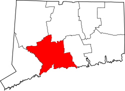 | |
| Towns | ||
| Borough | ||
| Other communities | ||