Dera Ghazi Khan International Airport
| Dera Ghazi Khan International Airport ڈیرہ غازی خان بین الاقوامی ہوائی اڈا Ḍerah G̱ẖāzī Ḵẖān Bain al-Aqvāmī Havā'ī Aḍā | |||||||||||
|---|---|---|---|---|---|---|---|---|---|---|---|
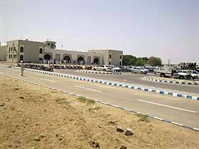 Dera Ghazi Khan international Airport | |||||||||||
| Summary | |||||||||||
| Airport type | Public | ||||||||||
| Operator | Pakistan Civil Aviation Authority | ||||||||||
| Serves | Dera Ghazi Khan, Punjab, Pakistan | ||||||||||
| Elevation AMSL | 148 m / 486 ft | ||||||||||
| Coordinates | 29°57′39″N 070°29′09″E / 29.96083°N 70.48583°ECoordinates: 29°57′39″N 070°29′09″E / 29.96083°N 70.48583°E | ||||||||||
| Map | |||||||||||
 DEA Location of the airport in Pakistan | |||||||||||
| Runways | |||||||||||
| |||||||||||
| Statistics (2016-17[1]) | |||||||||||
| |||||||||||
|
Source: | |||||||||||
Dera Ghazi Khan international Airport or D. G. Khan int. Airport (IATA: DEA, ICAO: OPDG) (Saraiki, Urdu: ڈیرہ غازی خان بین الاقوامی ہوائی اڈا) is 15 km (9.3 mi) from the city centre of Dera Ghazi Khan, Punjab, Pakistan. It caters mainly to the population of Dera Ghazi Khan. The airport provides flights to Karachi.
Airlines and destinations
| Airlines | Destinations |
|---|---|
| Pakistan International Airlines | Karachi |
See also
References
- ↑ http://www.caapakistan.com.pk/AT/AT-EO-Stats.aspx
- ↑ Airport information for OPDG at World Aero Data. Data current as of October 2006.Source: DAFIF.
- ↑ Airport information for DEA at Great Circle Mapper. Source: DAFIF (effective October 2006).
External links
This article is issued from
Wikipedia.
The text is licensed under Creative Commons - Attribution - Sharealike.
Additional terms may apply for the media files.