Cauca Department
| Department of Cauca Departamento del Cauca | |||
|---|---|---|---|
| Department | |||
| |||
|
Motto(s): Por el Derecho a la Diferencia (Spanish: For the Right to a Difference) | |||
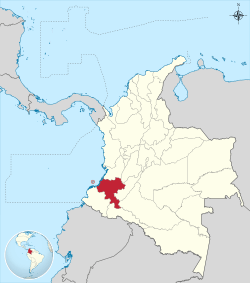 Cauca shown in red | |||
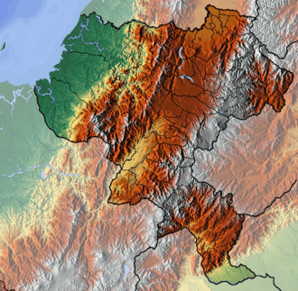 Topography of the department | |||
| Coordinates: 2°27′N 76°37′W / 2.450°N 76.617°WCoordinates: 2°27′N 76°37′W / 2.450°N 76.617°W | |||
| Country |
| ||
| Region | Andean Region/Pacific Region | ||
| Established | June 15, 1857 | ||
| Capital | Popayán | ||
| Government | |||
| • Governor | Oscar Rodrigo Campo Hurtado (2016-2019) | ||
| Area | |||
| • Total | 29,308 km2 (11,316 sq mi) | ||
| Area rank | 13th | ||
| Population (2013)[1] | |||
| • Total | 1,354,744 | ||
| • Rank | 11th | ||
| • Density | 46/km2 (120/sq mi) | ||
| Time zone | UTC-05 | ||
| ISO 3166 code | CO-CAU | ||
| Municipalities | 41 | ||
| Website | |||


Cauca Department (Spanish pronunciation: [ˈkawka], Spanish: Departamento del Cauca) is a Department of Colombia. Located in the southwestern part of the country, facing the Pacific Ocean to the west,[2] the Valle del Cauca Department to the north, Tolima Department to the northeast, Huila Department to the east, and Nariño Department to the south. Putumayo and Caqueta Departments border the southeast portion of Cauca Department as well. It covers a total area of 29,308 km2 (11,316 sq mi), the 13th largest in Colombia. Its capital is the city of Popayán. The offshore island of Malpelo belongs to the department. It is located in the southwest of the country on the Andean and Pacific regions (between 0°58′54″N and 3°19′04″N latitude, 75°47′36″W and 77°57′05″W longitude). The area includes 2.56% of the country.
Administrative Division

Cauca department is divided into 42 municipalities, 99 districts, 474 police posts and numerous villages and populated places. The municipalities are grouped into 27 circles and 29 notaries notary, a circle-based registration in Popayán and eight sectional offices based in Bolívar, Caloto, Puerto Tejada, Santander de Quilichao, Patia, Guapi and Silvia, makes up the judicial district, Popayán, with 8 seats judicial circuit in Popayán, Bolívar, Caloto, Guapi, Patia, Puerto Tejada, Santander de Quilichao and Silvia. The department makes up the constituency of Cauca.
Physiography
The relief of the territory of the department of Cauca belongs to the Andean system at the macro level seven distinguishing morphological units: the Pacific plate, western cordillera, Central cordillera, highlands of Popayán, Macizo Colombiano, Valle del Patia and the sector of the Amazon basin. The Pacific plate comprises two sectors, the alluvial coastal belt or platform characterized by low, covered with mangrove forest, swampy, both the quantity of rivers, estuaries and reaching the Pacific coast, such as being subjected the ebb and flow of tides, the other area is the actual plain of hills comprising the western slopes of the western cordillera.
The western cordillera in the Cauca extends from southwest to northeast. Among the most important landmarks are the blade of Napí, the hills of Guaduas, Munchique, and Naya, and the Cauca River Valley. The central mountain range crosses the department from south to north; relevant landmarks include Sotará Colcano, Petacas Nevado del Huila, and the departmental boundary.
The highlands of Popayán, sandwiched between the Western and Central Cordilleras, is seen as a landmark within the plateau of the hill of La Tetilla. Among the most representative landmarks of the Colombian Massif, shared with the department of Huila, are the Páramo del Buey, the volcanoes of Cutanga and Puracé, the peak of Paletará, and the Sierra Nevada of Coconucos. Patia Valley, framed by the Central and Western mountain ranges, where the Patia River runs north-south extends to the department of Nariño. The Amazon Basin, corresponds to the so-called Bota Caucana, through which the Caquetá river.
Colombian Massif
The Colombian Massif, also called the Nudo de Almaguer, is a mountainous group of "Andes colombianos" covering the departments of Cauca, Huila, and Nariño. In the south is the Nudo de los Pastos, and the north, central, and eastern mountain ranges emerge. The Colombian Massif is a strategic national and international level, given its significance for water production, biodiversity and ecosystems, an area that represents a special conformation of the regions with more potential for development in Colombia.
Hydrography
The Cauca river system, consists of five major basins: Alto Cauca, Pacific, Alto Magdalena, Patia and Caqueta.
Alto Cauca, formed by the Cauca River and its tributaries: Palo, Guengué, Negro, Teta, Desbaratado, and Quilichao, Mondomo, Ovejas, Pescador, Robles, Piedras, Sucio, Palacé, Cofre, Honda, Cajibío, Piendamó, Tunia, Molino, Timbío and Blanco.
The Pacific, made up mainly by rivers Guapi, Timbiquí, Saija and Micay.
Alto Magdalena, the main river is the Páez River which is fed by the rivers: San Vicente, Moras, Ullucos, Negro y Negro de Narvaez, and the streams: Toez, Símbola, Salado, Gualcar, Gallo, Macana, Honda and Totumo.
Patia basin, consists of the Patia River and its tributary rivers Guachinoco, Ismita, Bojoleo, El Guaba, Sambingo and Mayo.
Caquetá basin, consists of the Caquetá River where the rivers Cusiyaco, Cascabelito, Verdeyaco, Mandiyaco, Fragua, Cascabel, Curiaco and Pacayaco. Gorgonilla and Gorgona islands are located in the Pacific Ocean, belong to the territory Cauca.
Economy
The Cauca economy is based primarily on agriculture and livestock production, forestry, fishing and trade. Agriculture has been developed and modernized in the northern department, with the main crops being sugar cane, cane panela, conventional maize, rice, corn tech, banana, agave, yucca, potatoes, coconut, sorghum, cocoa, groundnut, and palm.
In the Pacific region is extracted gold, silver and platinum. Other non-precious minerals that are exploited are sulfur, asbestos, limestone, talc, gypsum and coal. The manufacturing industry is located in Popayán, Santander de Quilichao, Puerto Tejada with factories of food, beverages, dairy products, paper, packaging, wood processing, sugar industry and paper processing for export. The main centers of commercial activity are Popayán, Santander de Quilichao, Patia, Puerto Tejada, Piendamó and Corinto.
Municipalities
- Almaguer
- Argelia
- Balboa
- Bolívar
- Buenos Aires
- Cajibío
- Caldono
- Caloto
- Corinto
- El Tambo
- Florencia
- Guapi
- Inzá
- Jambaló
- La Sierra
- La Vega
- López de Micay
- Mercaderes
- Miranda
- Morales
- Padilla
- Páez
- Patía
- Piamonte
- Piendamó
- Popayán
- Puerto Tejada
- Puracé
- Rosas
- San Sebastián
- Santander de Quilichao
- Santa Rosa
- Silvia
- Sotará
- Suárez
- Sucre
- Timbío
- Timbiquí
- Toribío
- Totoró
- Villa Rica
- Zarzal
References
- ↑ "DANE". Archived from the original on November 13, 2009. Retrieved February 13, 2013.
- ↑

External links
- Official website

- Territorial-Environmental Information System of Colombian Amazon SIAT-AC website
 | ||