Dellwood, Adams County, Wisconsin
| Dellwood, Wisconsin | |
|---|---|
| Census-designated place | |
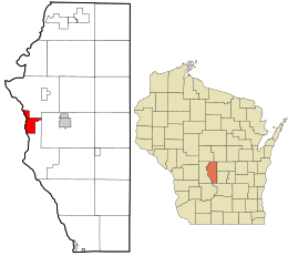 Location in Adams County and the state of Wisconsin.t | |
| Coordinates: 43°59′03″N 89°56′19″W / 43.98417°N 89.93861°WCoordinates: 43°59′03″N 89°56′19″W / 43.98417°N 89.93861°W | |
| Country | United States |
| State | Wisconsin |
| County | Adams |
| Town | Strongs Prairie |
| Area | |
| • Total | 5.364 sq mi (13.89 km2) |
| • Land | 5.236 sq mi (13.56 km2) |
| • Water | 0.128 sq mi (0.33 km2) |
| Elevation | 912 ft (278 m) |
| Population (2010 census) | |
| • Total | 563 |
| • Density | 100/sq mi (41/km2) |
| Time zone | UTC-6 (Central (CST)) |
| • Summer (DST) | UTC-5 (CDT) |
| ZIP code | 53927 |
| Area code(s) | 608 |
| GNIS feature ID | 1563891[1] |
Dellwood (also known as Delwood[2]) is an unincorporated census-designated place located in Adams County, Wisconsin, United States. Dellwood is west of Friendship, in the town of Strongs Prairie. Dellwood has a post office with ZIP code 53927.[3] As of the 2010 census, its population was 563.[4]
References
Municipalities and communities of Adams County, Wisconsin, United States | ||
|---|---|---|
| Cities | 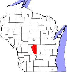 | |
| Village | ||
| Towns | ||
| CDPs | ||
| Unincorporated communities | ||
| Ghost towns/neighborhoods | ||
| Indian reservation | ||
| Footnotes | ‡This populated place also has portions in an adjacent county or counties | |
This article is issued from
Wikipedia.
The text is licensed under Creative Commons - Attribution - Sharealike.
Additional terms may apply for the media files.