Cottonville, Wisconsin
| Cottonville, Wisconsin | |
|---|---|
| Unincorporated community | |
 Cotton- ville  Cotton- ville | |
| Coordinates: 44°03′30″N 89°48′23″W / 44.05833°N 89.80639°WCoordinates: 44°03′30″N 89°48′23″W / 44.05833°N 89.80639°W | |
| Country | United States |
| State | Wisconsin |
| County | Adams |
| Town | Preston |
| Elevation | 965 ft (294 m) |
| Time zone | UTC-6 (Central (CST)) |
| • Summer (DST) | UTC-5 (CDT) |
| Area code(s) | 608 |
| GNIS feature ID | 1837579[1] |
Cottonville is an unincorporated community located in the town of Preston, Adams County, Wisconsin, United States. Cottonville is located on Wisconsin Highway 13 and Big Roche Cri Creek 6 miles (9.7 km) north of Friendship.[2] Originally named Roche-A-Cree, Cottonville was named after Julius Cotton who built a dam and sawmill on Big Roche-a-Cri Creek in the 1850s.[3]
References
- ↑ U.S. Geological Survey Geographic Names Information System: Cottonville, Wisconsin
- ↑ Adams County (PDF) (Map). Wisconsin Department of Transportation. Archived from the original (pdf) on May 16, 2011. Retrieved May 22, 2011.
- ↑ Callary, Edward. Place Names of Wisconsin. Madison, WI: University of Wisconsin Press. p. 66. ISBN 978-0-299-30964-0.
Municipalities and communities of Adams County, Wisconsin, United States | ||
|---|---|---|
| Cities | 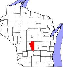 | |
| Village | ||
| Towns | ||
| CDPs | ||
| Unincorporated communities | ||
| Ghost towns/neighborhoods | ||
| Indian reservation | ||
| Footnotes | ‡This populated place also has portions in an adjacent county or counties | |
This article is issued from
Wikipedia.
The text is licensed under Creative Commons - Attribution - Sharealike.
Additional terms may apply for the media files.