Dashti County
| Dashti County شهرستان دشتی | |
|---|---|
| County | |
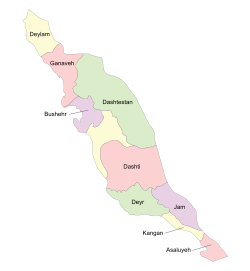 Location in Bushehr Province | |
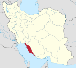 Location of Bushehr Province in Iran | |
| Coordinates: 28°29′N 51°33′E / 28.483°N 51.550°ECoordinates: 28°29′N 51°33′E / 28.483°N 51.550°E | |
| Country |
|
| Province | Bushehr Province |
| Capital | Khormuj |
| Bakhsh (Districts) | Central District, Kaki District, Shonbeh and Tasuj District |
| Population (2006) | |
| • Total | 71,285 |
| Time zone | UTC+3:30 (IRST) |
| • Summer (DST) | UTC+4:30 (IRDT) |
| Dashti County can be found at GEOnet Names Server, at this link, by opening the Advanced Search box, entering "9206094" in the "Unique Feature Id" form, and clicking on "Search Database". | |
Dashti County (Persian: شهرستان دشتی) is one of the nine counties (shahrestans) in Bushehr Province, Iran. It has an area of 5,008 km². At the 2006 census, the county's population was 71,285, in 15,465 families.[1] The population is Muslim and they speak various forms of Persian languages including Farsi and the local Dashti. The capital of the county is Khormuj. The county is subdivided into three districts: the Central District, Kaki District, and Shonbeh and Tasuj District. The county has four cities: Kaki, Khormuj, Baduleh and Shonbeh.
Dashti County is bounded by the Persian Gulf to the west, Tangestan County to the north and west, Dashtestan County to the northeast, Dayyer County and Kangan County and to the south, Jam County to the southeast, and Firuzabad County to the east. Its central geographic coordinates are: Longitude: 51 10 - 52 10 N, Latitude: 28 10 – 28 45 E
Dashti County has a 25 km coastline along the Persian Gulf, with a climate that is mostly arid or semiarid. The highest point in the county is Mount Beyrami at 1,950 m. Petroleum, natural gas, lime, and stone from quarries are extracted in the county. Wheat, tomatoes, corn, and other grains are grown. There is a local honey industry.
Tourist attractions
- Khormooj fortress
- Dokhtar fortress, located in Lavar-e saheli village
- Darab khan fortress, located in Shonbeh village
- Bahman dan fortress, located in Kaki city
- Mond temple
- Shirine building
- Mond River
- Mount Beyremi
- Mir Aram tomb
- Seyyed Mohammad Amin tomb, located in Kaki city
- Pir hashem tomb, located in Jabri village
- Shahzade Mohammad tomb, located in Sheikhyan village
- Dike Dojhtar, located in the Kaki city
- Baghan village
- Laver-e sharqi village
2013 Dashti County earthquake
A strong earthquake measuring 6.1 on the Richter scale struck the town of Shonbeh and villages of Shonbeh and Tasuj District in Dashti County on 9 April 2013, killing at least thirty-seven people. [2]
References
- ↑ "Census of the Islamic Republic of Iran, 1385 (2006)". Islamic Republic of Iran. Archived from the original (Excel) on 2011-11-11.
- ↑ Iran quake kills 37, injures more than 850
- اطلس گیتاشناسی استانهای ایران [Atlas Gitashenasi Ostanhai Iran] (Gitashenasi Province Atlas of Iran)
External links
| Wikimedia Commons has media related to Dashti county. |
| Capital |  | ||||||||||||||||||||
|---|---|---|---|---|---|---|---|---|---|---|---|---|---|---|---|---|---|---|---|---|---|
| Counties and cities |
| ||||||||||||||||||||
| Landmarks |
| ||||||||||||||||||||
| populated places | |||||||||||||||||||||
| Capital | |||||||||||||||||||||||||||||||||
|---|---|---|---|---|---|---|---|---|---|---|---|---|---|---|---|---|---|---|---|---|---|---|---|---|---|---|---|---|---|---|---|---|---|
| Districts |
| ||||||||||||||||||||||||||||||||