Dark Peak

The Dark Peak is the higher and wilder part of the Peak District in England, mostly forming the northern Peak District but also extends south into its eastern and western margins. It is mainly in Derbyshire and parts of Staffordshire, Cheshire, Greater Manchester, West Yorkshire and South Yorkshire.
It gets its name because (in contrast to the White Peak), the underlying limestone is covered by a cap of Millstone Grit which means that in winter the soil is almost always saturated with water. The land is thus largely uninhabited moorland plateaux where almost any depression is filled with sphagnum bogs and black peat. The High Peak is an alternative name for the Dark Peak, but High Peak is also the name of an administrative district of Derbyshire which includes part of the White Peak.
The areas of Millstone Grit form an 'inverted horseshoe' around the lower uncapped limestone areas of the White Peak, enclosing it to the west, north and east.[1] Hence the Dark Peak is said to cover the higher moors north of the Hope Valley, as well as the Western Moors stretching south to near the Churnet Valley, and the Eastern Moors southwards towards Matlock. The Dark Peak is one of 159 National Character Areas defined by Natural England; as defined by Natural England, the Dark Peak NCA covers 86,604 hectares (334 sq mi) and includes the northern block of hills approximately bounded by Marsden, Stocksbridge, Hathersage and Chapel-en-le-Frith, plus the eastern moors south to Matlock,[2] but excludes the western moors between Chapel and the Churnet Valley (which it places in NCA 53, the South West Peak),[3] and the area around Glossop (in NCA 54, Manchester Pennine Fringe).[4]
An area of 31,852 hectares (123 sq mi) is designated as the Dark Peak Site of Special Scientific Interest (SSSI),[5] which excludes the separately designated Eastern Moors.[6] The SSSI extends over the borders into Greater Manchester and West Yorkshire. A large part of the SSSI is included in the South Pennine Moors Special Area of Conservation.[7]
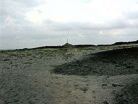
Principal upland areas within the Dark Peak include Kinder Scout, Bleaklow (both of which rise to over 600 m (2,000 ft), and lie wholly within Derbyshire), Black Hill, the Roaches, Shining Tor and Stanage Edge.
Over the years, a number of military aircraft have crashed on the Dark Peak, generally due to a combination of numerous nearby air bases, inexperienced pilots, primitive or faulty equipment and poor visibility.[8] Because of the bleakness and emptiness of the high moorlands and the consequent difficulties of recovery,[9] substantial wreckage remains at some sites in remote parts of the moorland, though militarily sensitive materials were removed and salvage teams sometimes gathered debris into piles, or burned or buried it.[10] There have been reports of ghost planes in the area, usually of a low-flying, propeller-driven plane seemingly in difficulty before crashing into the moors. People who recovered items from the crash site were allegedly then visited by ghosts.[11]
References
- ↑ "Accommodation in Derbyshire and the Peak National Park". Discover Derbyshire and the Peak District. Discover Derbyshire and the Peak District. Retrieved 12 August 2018.
- ↑ "NCA Profile: 51 Dark Peak (NE378)". Natural England. Retrieved 4 April 2013.
- ↑ "South West Peak". Scottish Natural Heritage. Scottish Natural Heritage. Retrieved 21 September 2018.
- ↑ "NCA Profile: 54 Manchester Pennine Fringe (NE397)". Natural England. Natural England. Retrieved 21 September 2018.
- ↑ "The Dark Peak (SSSI citation)" (PDF). Natural England. 8 July 1993. Retrieved 4 April 2013.
- ↑ "Eastern Peak District Moors (SSSI citation)" (PDF). Natural England. 22 December 1999. Retrieved 4 April 2013.
- ↑ SAC Standard Data Form
- ↑ McCloy, Andrew. "Walking the Peak District Aircraft Wrecks". Mammut UK. Retrieved 21 September 2018.
- ↑ "ASN Wikibase Occurrence # 18762". Aviation Safety Network. Retrieved 21 September 2018.
- ↑ Cunningham, Pat (2006). Peakland Air Crashes: The North. Ashbourne: Landmark Publishing. p. 13. ISBN 1843063301.
- ↑ "Ghost Places of the Peak District of Derbyshire". Sheffield on the Internet. Retrieved 21 September 2018.