Danville, Allegany County, Maryland
| Danville, Maryland | |
|---|---|
| Census-designated place | |
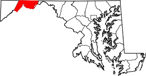
 Danville Location within the State of Maryland  Danville Danville (the US) | |
| Coordinates: 39°30′20″N 78°55′41″W / 39.50556°N 78.92806°WCoordinates: 39°30′20″N 78°55′41″W / 39.50556°N 78.92806°W | |
| Country |
|
| State |
|
| County |
|
| Area | |
| • Total | 1.2 sq mi (3.0 km2) |
| • Land | 1.2 sq mi (3.0 km2) |
| • Water | 0 sq mi (0 km2) |
| Elevation | 1,111 ft (339 m) |
| Population (2010) | |
| • Total | 271 |
| • Density | 238/sq mi (91.8/km2) |
| Time zone | UTC−5 (Eastern (EST)) |
| • Summer (DST) | UTC−4 (EDT) |
| FIPS code | 24-21675 |
| GNIS feature ID | 2583604 |
Danville is an unincorporated community and census-designated place (CDP) in Allegany County, Maryland, United States.[1] As of the 2010 census it had a population of 271.[2]
It is along U.S. Route 220, 14 miles (23 km) southwest of Cumberland, Maryland, and 6 miles (10 km) northeast of Keyser, West Virginia. The community lies in a valley bounded by 2,800-foot (850 m) Dans Mountain to the northwest and 1,500-foot (460 m) Fort Hill to the southeast.
References
- ↑ "Geographic Names Information System". Danville (Populated Place). U.S. Geological Survey. 2009-01-29.
- ↑ "Geographic Identifiers: 2010 Demographic Profile Data (G001): Danville CDP, Maryland". U.S. Census Bureau, American Factfinder. Retrieved May 24, 2013.
This article is issued from
Wikipedia.
The text is licensed under Creative Commons - Attribution - Sharealike.
Additional terms may apply for the media files.