Daniëlskuil
| Daniëlskuil | |
|---|---|
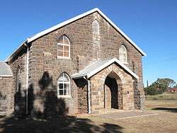 Second Dutch Reformed Church, Danielskuil | |
 Daniëlskuil  Daniëlskuil Daniëlskuil (South Africa)  Daniëlskuil Daniëlskuil (Africa) | |
| Coordinates: 28°12′S 23°35′E / 28.200°S 23.583°ECoordinates: 28°12′S 23°35′E / 28.200°S 23.583°E | |
| Country | South Africa |
| Province | Northern Cape |
| District | ZF Mgcawu |
| Municipality | Kgatelopele |
| Area[1] | |
| • Total | 174.63 km2 (67.43 sq mi) |
| Population (2011)[1] | |
| • Total | 13,597 |
| • Density | 78/km2 (200/sq mi) |
| Racial makeup (2011)[1] | |
| • Black African | 47.4% |
| • Coloured | 44.5% |
| • Indian/Asian | 0.8% |
| • White | 6.3% |
| • Other | 1.0% |
| First languages (2011)[1] | |
| • Afrikaans | 63.0% |
| • Tswana | 30.9% |
| • English | 1.8% |
| • Xhosa | 1.1% |
| • Other | 3.2% |
| Time zone | UTC+2 (SAST) |
| Postal code (street) | 8405 |
| PO box | 8405 |
Daniëlskuil is a town in ZF Mgcawu District Municipality in the Northern Cape province of South Africa.
Description
The settlement is 142 kilometres (88 mi) north-west of Kimberley and 72 km (45 mi) north-east of Postmasburg. It takes its name from a cone-shaped depression 6 metres (20 ft) deep in the dolomitic limestone; with a domed covering, reminiscent of the biblical ‘Daniel in the lions' den’ (Afrikaans: kuil, ‘hole’, ‘pit’). The Griqua leader Adam Kok is said to have used this depression as a prison, and to also have kept snakes in it. The area is known for rich asbestos deposits and for diamonds, while marble is also mined. The Tswana name of Danielskuil is Tlaka le Tlou or Tlaka-lo-Tlou, ‘elephant reed’.[2]
References
- 1 2 3 4 "Main Place Daniëlskuil". Census 2011.
- ↑ "Dictionary of Southern African Place Names (Public Domain)". Human Science Research Council. p. 128.
External links

Municipalities and communities of ZF Mgcawu District Municipality, Northern Cape | ||
|---|---|---|
District seat: Upington | ||
| Dawid Kruiper | .svg.png) | |
| Kai !Garib | ||
| Kgatelopele | ||
| !Kheis | ||
| Tsantsabane | ||
This article is issued from
Wikipedia.
The text is licensed under Creative Commons - Attribution - Sharealike.
Additional terms may apply for the media files.