Damazin Airport
| Damazin Airport | |||||||||||
|---|---|---|---|---|---|---|---|---|---|---|---|
| Summary | |||||||||||
| Airport type | Public | ||||||||||
| Operator | Government | ||||||||||
| Location | Damazin, Sudan | ||||||||||
| Elevation AMSL | 1,582 ft / 482 m | ||||||||||
| Coordinates | 11°47′09″N 034°20′11″E / 11.78583°N 34.33639°ECoordinates: 11°47′09″N 034°20′11″E / 11.78583°N 34.33639°E | ||||||||||
| Map | |||||||||||
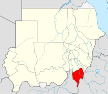 HSDZ Location of airport in Sudan (Blue Nile state highlighted) | |||||||||||
| Runways | |||||||||||
| |||||||||||
Damazin Airport (IATA: RSS, ICAO: HSDZ) is an airport serving Damazin,[1] located in the Blue Nile state in Sudan.
Facilities
The airport resides at an elevation of 1,582 feet (482 m) above mean sea level. It has one runway designated 17/35 with an asphalt surface measuring 2,500 by 45 metres (8,202 ft × 148 ft).[1]
References
- 1 2 3 Airport information for HSDZ from DAFIF (effective October 2006)
- ↑ Airport information for HSDZ at Great Circle Mapper. Source: DAFIF (effective October 2006).
External links
This article is issued from
Wikipedia.
The text is licensed under Creative Commons - Attribution - Sharealike.
Additional terms may apply for the media files.