Dala Township
| Dalla Township ဒလ ျမိဳ့နယ္ | |
|---|---|
| Township of Yangon | |
| Dalla Township | |
 Dalla Township | |
| Coordinates: 16°45′30″N 96°9′30″E / 16.75833°N 96.15833°ECoordinates: 16°45′30″N 96°9′30″E / 16.75833°N 96.15833°E | |
| Country | Myanmar |
| Division | Yangon |
| City | Yangon |
| Township | Dalla |
| Area | |
| • Total | 224.1 km2 (86.51 sq mi) |
| Population (2000)[1] | |
| • Total | above 150,000 |
| Time zone | UTC6:30 (MST) |
| • Summer (DST) | UTC16°45'25"N 96°9'37 |
| Postal codes | 11261 |
| Area code(s) | 1 (mobile: 80, 99) |
| YCDC[1] | |
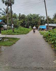
Dalla Township (Burmese: ဒလ ျမိဳ့နယ္, pronounced [dəla̰ mjo̰nɛ̀]) is located on the southern bank of Yangon river across from downtown Yangon, Myanmar. The township, made up of 23 wards and 23 village track (including 50 villages), is bounded by the Yangon river in the north and east, the Twante Canal in the west, and Twante Township in the south.
History
In 1805, Alaungpaya's fourth son King Bodawpaya appointed Htaw Lay as the governor (myoza) of Dala (modern Dala and Twante).
In colonial era, Dalla was the site of the major shipyard of the Irrawaddy Flotilla Company.[2]
Contemporary
Despite its strategic location near Yangon, the township is still largely rural and undeveloped mainly because it still lacks a bridge across the Yangon river, with connections between the township and the city being by ferry only. A bridge project was announced for 2017, with an MOU signed with a Korean company, however no building work had begun by June 2017. Dalla has 30 primary schools and two high schools.[1]
References
- 1 2 3 "Dalla Township". Yangon City Development Committee. Archived from the original on 2 October 2011. Retrieved 21 March 2009.
- ↑ Chubb, Capt H J; Duckworth, C L D (1973). The Irrawaddy Flotilla Company 1865-1950. Greenwich, London: National Maritime Museum.
| Wikimedia Commons has media related to Dala Township. |
Capital: Yangon | ||
| East Yangon District | 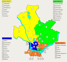 | |
| North Yangon District | ||
| South Yangon District | ||
| West Yangon District (Downtown) | ||
1 - part of South Yangon City; 2 - part of North Yangon City | ||
Capital: Yangon | ||
| East Yangon Region |   | |
| North Yangon Region | ||
| South Yangon Region | ||
| West Yangon Region (Downtown) | ||
| Main cities and towns | ||
1 - part of South Yangon City; 2 - part of North Yangon City | ||