Dôme du Goûter
| Dôme du Goûter | |
|---|---|
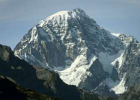
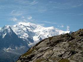 Mont Blanc (centre left) and the Dôme du Goûter (right) | |
| Highest point | |
| Elevation | 4,304 m (14,121 ft) |
| Prominence | 58 m ↓ Col du Dôme [1] |
| Isolation | 1.98 km → Mont Blanc |
| Coordinates | 45°50′34″N 6°50′36″E / 45.84278°N 6.84333°ECoordinates: 45°50′34″N 6°50′36″E / 45.84278°N 6.84333°E |
| Geography | |
 Dôme du Goûter Alps | |
| Location | Haute-Savoie, France / Aosta Valley, Italy |
| Parent range | Graian Alps |
| Geology | |
| Mountain type | Granite/Porphyry |
| Climbing | |
| First ascent | 17 September 1784 by Jean-Marie Couttet and François Cuidet |
| Easiest route | From Refuge du Goûter, 3,817 m, (F) |
The Dôme du Goûter (4,304 m) is a mountain in the Mont Blanc massif. It is a shoulder of Mont Blanc, whose summit lies two kilometres to the south-east. The Dôme is traversed on ascents of Mont Blanc via the Bosses route.
The summit of the Dôme is marked as lying entirely within France on the French Institut Géographique National (IGN) map , although on Italian Istituto Geografico Militare (IGM) map the summit appears to lie on the frontier between France and Italy.
Refuge du Gouter
In 2014, the Refuge du Gouter opened, a mountain hut noted for its modern style.[2] From the hut the summit of the Dome du Gouter is about two hours away by foot.[3] The hut is located above the Aiguille du Gouter cliff and is constructed of wood and steel in a roughly egg shape.[4] The older shelter was a more basic metal shed that sat on the ice, whereas the new building has supports drilled into the rock.[2]
References
- ↑ Mountains above 4000 metres in the Alps
- 1 2 Todd, Andrew (2015-10-21). "Eco-friendly architecture in the Alps hits new heights". The Guardian. ISSN 0261-3077. Retrieved 2017-05-30.
- ↑
- ↑ Todd, Andrew (2015-10-21). "Eco-friendly architecture in the Alps hits new heights". The Guardian. ISSN 0261-3077. Retrieved 2017-05-30.
External links