Cyclone Nina
| Category 3 severe tropical cyclone (Aus scale) | |
|---|---|
| Category 1 tropical cyclone (SSHWS) | |
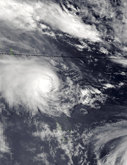 Severe Tropical Cyclone Nina on January 2, 1993 | |
| Formed | December 21, 1992 |
| Dissipated | January 5, 1993 |
| Highest winds |
10-minute sustained: 140 km/h (85 mph) 1-minute sustained: 140 km/h (85 mph) |
| Lowest pressure | 960 hPa (mbar); 28.35 inHg |
| Areas affected | Queensland, Solomon Islands, Rotuma, Wallis and Futuna, Tuvalu, Tonga, Niue |
| Part of the 1992–93 Australian region and the South Pacific cyclone season | |
Severe Tropical Cyclone Nina was a significant tropical cyclone, which impacted six island nations and caused several deaths. The system was first noted as a tropical low over the Cape York Peninsula on December 21. Over the next few days the system moved south-westwards and moved into the Gulf of Carpentaria where it was named Nina, after it had developed into a tropical cyclone during December 23. The system was subsequently steered south-eastwards by an upper level trough of low pressure, before it made landfall as a Category 2 tropical cyclone on the Cape York Peninsula near Cape Keerweer during December 25. Over land the system weakened into a tropical low before it regenerated into a tropical cyclone over the Coral Sea during December 28. The system subsequently moved north-eastwards, under the influence of Severe Tropical Cyclone Kina and an upper level ridge of high pressure. During January 1, 1993, Nina peaked with sustained wind speeds of 140 km/h (85 mph), as it affected Rennell, Bellona and Temotu provinces in the Solomon Islands. The system subsequently gradually weakened as it accelerated eastwards and affected Rotuma, Wallis and Futuna, Tonga and Niue. Nina was subsequently absorbed by Kina, while both systems were located near the Southern Cook Islands during January 5.
Meteorological history
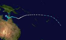
During the middle of December 1992, an active phase of the Madden–Julian oscillation took place which helped to reinforce atmospheric convection across Northern Australia and the western Pacific Ocean.[1] A tropical low subsequently developed, within this area of atmospheric convection over the Cape York Peninsula, under the influence of the warm waters of the Gulf of Carpentaria during December 21.[2][3] Over the next couple of days, the system moved south-westwards and moved into the Gulf of Carpentaria, where the upper level support was favourable for further development.[1][3] During December 23, the Australian Bureau of Meteorology named the system: Nina, after it had developed into a Category 1 tropical cyclone on the Australian tropical cyclone intensity scale.[4] During that day the United States Joint Typhoon Warning Center initiated advisories and designated the system as Tropical Cyclone 03P, while Nina started to be steered south-eastwards by an upper level trough of low pressure.[1][5] Over the next day the system continued to intensify before both the JTWC and the BoM reported that Nina had peaked with winds of 100 km/h (65 mph) during December 25, which made it a category 2 tropical cyclone on the Australian scale.[3][6] The system subsequently made landfall on the Cape York Peninsula during that day near Cape Keerweer, where it started to weaken and became a tropical low as it emerged into the Coral Sea during December 27.[1][6][7]
The system re-intensified into a tropical cyclone during December 28, as it moved north-eastwards, under the influence of Severe Tropical Cyclone Kina and an upper level ridge of high pressure.[1] Over the next few days, the system continued to re-intensify as it moved north-eastwards, before both the JTWC and the BoM reported that Nina had peaked with winds of 140 km/h (85 mph).[1][3][6] This made it a Category 3 severe tropical cyclone on the Australian scale and equivalent to a category 1 hurricane on the Saffir–Simpson hurricane wind scale.[3][6][8] During January 1, Nina passed over Rennell Island at its peak intensity, as it moved into the South Pacific basin.[4][8] Over the next few days, the system gradually weakened, as it accelerated eastwards through Temotu Province and around the eastern side of Kina.[4][9][10] During January 3, Nina passed to the north of the Fijian dependency of Rotuma, before it passed in between the islands of Wallis and Futuna.[4] During the next day the system weakened into a tropical low, as it turned south-eastwards and passed in between Tonga and Niue, before it was absorbed into Kina's circulation, while both systems were located near the Southern Cook Islands during January 5.[4][9]
Preparations and impact
Severe Tropical Cyclone Nina impacted the Gulf of Carpentaria, the Cape York Peninsula, Niue, Rotuma, Tonga, Tuvalu, the Solomon Islands, Wallis and Futuna.[4] Due to the impact of this system, the name Nina was subsequently retired, from the list of names for the Australian region by the World Meteorological Organization.[11]
Gulf of Carpentaria
As Nina developed in the Gulf of Carpentaria, tropical cyclone watches and warnings were issued, for parts of the Northern Territory and Queensland.[12] These areas included Nhulunbuy in the Northern Territory, Mapoon, Aurukun and the Lockhart River in Queensland.[12][13] The system subsequently moved eastwards and affected sparsely populated and uninhabited areas of the Cape York Peninsula, where torrential rainfall was recorded during December 25.[14] As a result of Nina impacting Queensland, the State Disaster Coordination Centre in Brisbane operated around the clock, while SES units, local authorities and disaster district coordinators in the region were put on full alert.[15][16] Ahead of the system affecting Port Stewart, ten members of a twenty-member fishing party were evacuated to safety while the other ten refused to be evacuated.[13] As a result, they were left stranded at the port, by the swollen Stewart River and its flooded tributaries until a rescue helicopter rescued them.[13][17] Within the Aurukun Aboriginal community and Pormpuraaw widespread damage to trees were reported, while four houses were damaged by flying tree branches.[7][18]
Solomon Islands
After impacting Queensland, Nina impacted the Solomon Islands between December 30 and January 3, where it caused extensive damage to southern and eastern islands including Rennell and Bellona.[10][19] Islanders were caught almost unprepared for Nina, because of preparations for the traditional New Year Celebrations.[4] There were 3 people killed in the islands with an elderly woman killed on Bellona after she was trapped under a collapsed house while twins born at the height also died from lack of warm dry linen and shelter.[4] The only buildings left standing were the Australian built Seventh Day Adventist churches in these islands.[4]
The Solomon Islands Government declared parts of Rennell and Bellona, Southern Guadalcanal, Temotu, Makira and Malaita Provinces disaster areas.[10] The Government subsequently shipped and airlifted relief materials to the affected areas, including food supplies, medical supplies, tarpaulins and water.[10] The Solomon Islands Red Cross also helped with the relief effort and dispatched 113 tarpaulins to four provinces to shelter the homeless, along with blankets, clothing and various household items.[10] They used reserve funds in order to transport these supplies to the islands affected by canoe and plane.[10] The Government of the Solomon Islands subsequently launched an appeal for international assistance, with food assistance, tapualins, tents, water containeds and chainsaws amongst the things asked for.[10] A need also existed for helicopters and aircraft services, in order for field assessments to take place and the transportation of water engineers.[10]
Rotuma, Wallis and Futuna, Samoa and Tonga
Ahead of the system affecting Rotuma, a storm force wind warning was issued for Rotuma, with sustained wind speeds of 95 km/h (60 mph) and wind gusts of up to 140 km/h (85 mph) were forecast to occur.[4] However, the system only had a minimal effect on Rotuma, with a few rain showers and sustained winds of 45 km/h (30 mph) occurring for a brief period.[4] In conjunction with Kina, Nina affected Wallis and Futuna between January 3–4, however, there were no tropical cyclone warnings were issued for the French Territory by the FMS.[4][20] Kina affected the island of Futuna during January 3, where sustained winds of up to 53 km/h (33 mph) and wind gusts of up to 69 km/h (43 mph) were recorded.[4] Nina affected Wallis Island later that day where sustained winds of up to 80 km/h (50 mph) and wind gusts of up to 68 km/h (42 mph) were recorded.[20][21] Within the islands some damage to crops and houses was reported.[4]
Ahead of Nina affecting the Samoan Islands, residents living near the sea were warned to move inland, while ships were ordered to remain in port.[22] The system subsequently passed to the south of the Samoan Islands during January 4, where it brought high winds and caused wind gusts of 95 km/h (60 mph) at Pago Pago in American Samoa.[23][24] Some minor damage to roofs, bananas and breadfruit was reported, while total damages in American Samoa to both property and crops were estimated at between $50 thousand and $500 thousand.[23]
Nina affected Northern Tonga during January 4, just after Kina had affected Tonga's southern islands with hurricane-force winds.[4][25] Ahead of Nina affecting the islands, a gale warning was issued for the islands of Niuafo'ou and Keppel, where some damage to houses and crops were recorded.[4] A gale warning was also issued for the island nation of Niue during January 4, where winds of up to 75 km/h (45 mph) caused damage to the island nations port.[4]
Tuvalu
After Severe Tropical Cyclone Joni had affected Tuvalu during the previous month, Nina and Kina indirectly impacted the island nation during the opening days of January 1993.[4][26][27] The systems contributed to the strength of the westerly winds that were already present over the islands, with winds of up to 130 km/h (80 mph) reported throughout the islands.[4][26] As these winds combined with a heavy westerly swell and high seas, where they caused flooding of up to 2 ft (0.61 m) over the islands of Nanumea, Nanumaga, Niutao, Nui and Vaitupu.[4][28] As a result, damage was reported to crops and several buildings in the island nation, including thirty houses.[26][29] The two cyclones caused a severe amount of erosion in the island nation, with the shoreline on Vaitupu, receding by about 5–6 m (16–20 ft).[27] The Vaitupu Fisheries Harbour, that had only just been built during 1992, was seriously damaged by waves attributed to the two cyclones.[30]
On the island of Nanumea, a poorly designed sea wall trapped the storm surge on the island, which caused salt water contamination of the island vegetation and killed several trees.[28] The An appeal for international assistance was subsequently made by the Government of Tuvalu, as supplied of food and other essentials like petrol and kerosene on the worst affected islands were running low.[26] International assistance was subsequently provided, by the United Nations Department of Humanitarian Affairs, who provided an emergency grant of US$10 thousand.[31] The European Commission also provided emergency aid to Tuvalu which enabled the Red Cross, to provide foodstuffs, shelter, medical supplies and utensils to people whose homes were destroyed.[32]
See also
References
- 1 2 3 4 5 6 Darwin Regional Specialised Meteorological Centre (1992). "December 1992" (PDF). Darwin Tropical Diagnostic Statement. Australian Bureau of Meteorology. 11 (12): 2. ISSN 1321-4233. Archived (PDF) from the original on December 6, 2015. Retrieved December 13, 2015.
- ↑ Beven, John L (December 31, 1992). "Weekly tropical cyclone summary #73 (December 20 – 27, 1992". Retrieved December 13, 2015.
- 1 2 3 4 5 Joint Typhoon Warning Center; Naval Pacific Meteorology and Oceanography Center. "Tropical Cyclone 06P (Nina) best track analysis". United States Navy, United States Air Force. Archived from the original on March 25, 2013. Retrieved July 8, 2014.
- 1 2 3 4 5 6 7 8 9 10 11 12 13 14 15 16 17 18 19 20 Tropical Cyclone Nina, December 21, 1992 – January 4, 1993 (Report). Fiji Meteorological Service. May 20, 1996. Archived from the original on December 5, 2015. Retrieved December 13, 2015.
- ↑ Joint Typhoon Warning Center (1994). Annual Tropical Cyclone Report: 1993 (PDF) (Report). United States Navy, United States Air Force. p. 216. Retrieved January 31, 2013.
- 1 2 3 4 "The Australian Tropical Cyclone Database" (CSV). Australian Bureau of Meteorology. A guide on how to read the database is available here.
- 1 2 Callaghan, Jeff (August 12, 2004). "Tropical Cyclone Impacts in the Gulf of Carpentaria from November to April 1858 to 2000" (PDF). Australian Severe Weather. Archived (PDF) from the original on December 21, 2015. Retrieved December 21, 2015.
- 1 2 Tropical Cyclone Nina, December 23, 1992 – January 2, 1993 (Report). Australian Bureau of Meteorology. Retrieved December 14, 2015.
- 1 2 MetService (May 22, 2009). "TCWC Wellington Best Track Data 1967–2006". International Best Track Archive for Climate Stewardship.
- 1 2 3 4 5 6 7 8 Solomon Islands: Tropical Cyclone Nina January 1993: UN DHA Situation Report 1 (Report). United Nations Office for the Coordination of Humanitarian Affairs. January 1993. Archived from the original on May 25, 2013. Retrieved December 15, 2015.
- ↑ RA V Tropical Cyclone Committee (May 5, 2015). Tropical Cyclone Operational Plan for the South-East Indian Ocean and the Southern Pacific Ocean 2014 (PDF) (Report). World Meteorological Organization. pp. 2B-1 , – 2B-4 (23–26). Archived (PDF) from the original on May 24, 2015. Retrieved December 13, 2015.
- 1 2 "Cyclone Nina builds up". Herald Sun. Australian Associated Press. December 24, 1992. – via Lexis Nexis (subscription required)
- 1 2 3 "Nina flood strands 10". Sunday Age. Australian Associated Press. December 25, 1992. p. 3. Retrieved December 21, 2015.
- ↑ "Cyclone dumps big wet on Gulf". Sunday Mail. Australian Associated Press. December 27, 1992. – via Lexis Nexis (subscription required)
- ↑ "Cyclone Nina poised to strike". Hobart Mercury. Australian Associated Press. December 25, 1992. – via Lexis Nexis (subscription required)
- ↑ Weiniger, Peter (December 26, 1992). "Cyclone Nina keeps gulf on the alert". The Age. p. 6. Retrieved December 21, 2015.
- ↑ "Ten stranded by Cyclone Nina". The Sun Herald. December 27, 1992. Retrieved December 21, 2015.
- ↑ Breen, Neil (December 26, 1992). "Cyclone Nina eases up after hitting Aurukun". Courier Mail. – via Lexis Nexis (subscription required)
- ↑ "Tropical Cyclones/Depressions that passed through Solomon Islands Region" (PDF). Solomon Islands Meteorological Service. September 13, 2009. Archived from the original (PDF) on March 9, 2013. Retrieved June 20, 2013.
- 1 2 "Wallis and Futuna Cyclone Passes De 1880 à nos jours". Météo-France. Archived from the original on July 1, 2014. Retrieved December 21, 2015.
- ↑ "Pacific storms leave 15 dead and thousands homeless". Agence France Presse. January 4, 1993.
- ↑ "Samoa bracing itself for Cyclone Nina". Agence France Presse. January 4, 1993.
- 1 2 Goodge, Grant W (ed.). "Storm Data and Unusual Weather Phenomena: January 1993" (PDF). 35 (1). National Climatic Data Center: 69. Archived from the original (PDF) on December 12, 2015. Retrieved December 20, 2015.
- ↑ Newmann, Steve (January 9, 1993). "Earthweek: a diary of the planet for the week ending January 8, 1993". The Toronto Star. – via Lexis Nexis (subscription required)
- ↑ Prasad, Rajendra; Nadi Tropical Cyclone Warning Center (May 20, 1996). Tropical Cyclone Kina, December 23, 1992 – January 5, 1993 (Tropical Cyclone Report 92/1). Fiji Meteorological Service. Archived from the original on March 21, 2013. Retrieved March 21, 2013.
- 1 2 3 4 "Tuvalu Cyclone Nina January 1993 DHA-UNDRO Situation Report 1" (PDF). Relief Web. The United Nations Department of Humanitarian Affairs. January 5, 1993. Archived from the original on March 9, 2013. Retrieved December 18, 2015.
- 1 2 Chunting, Xue (April 30, 2005). "Causes of Land Loss in Tuvalu, a small island nation in the Pacific" (PDF). Journal of Ocean University of China. 4 (2): 120. ISSN 1672-5182. Archived from the original (PDF) on December 20, 2015. Retrieved December 20, 2015.
- 1 2 Tuvalu’s Views on the Possible Security Implications of Climate Change to be included in the report of the UN Secretary General to the UN General Assembly 64th Session (PDF) (Report). The United Nations Department of Humanitarian Affairs. January 5, 1993. Archived from the original (PDF) on December 19, 2015. Retrieved December 18, 2015.
- ↑ Tuvalu national report prepared for the International Decade for Natural Disaster Reduction mid-term review and the 1994 World Conference on Natural Disaster Reduction, Yokohama, Japan, May 23-27, 1994 (PDF). Prevention Web (Report). February 16, 1994. p. 15. Archived (PDF) from the original on December 11, 2015. Retrieved December 11, 2015.
- ↑ Xue, Chunting (April 30, 2005). "Coastal erosion and management of Vaitupu Island, Tuvalu" (PDF). 4 (2). he Pacific Islands Applied Geoscience Commission: 120. ISSN 1672-5182. Archived from the original (PDF) on December 20, 2015. Retrieved December 20, 2015.
- ↑ OCHA-Geneva Contributions Report: Tuvalu — Cyclone "Nina" - January 1993 (Report). April 14, 1999. Archived from the original on December 19, 2015. Retrieved December 11, 2015.
- ↑ "EU-Tuvalu cooperation". The Courier. 149 (January–February 1995).
External links
- World Meteorological Organization
- Australian Bureau of Meteorology
- Fiji Meteorological Service
- New Zealand MetService
- Joint Typhoon Warning Center
Tropical cyclones of the 1992–93 Australian region cyclone season | ||
|---|---|---|
 | ||
| ||
Tropical cyclones of the 1992–93 South Pacific cyclone season | ||
|---|---|---|
 | ||
| ||
| 1960s | |
|---|---|
| 1970s | |
| 1980s | |
| 1990s | |
| 2000s | |
| 2010s | |
| |