Custer, Idaho
|
Custer Historic District | |
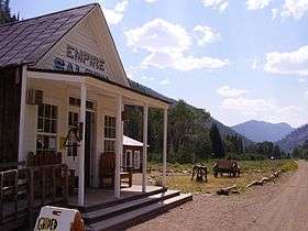 Empire Saloon | |
  | |
| Location | Yankee Fork Rd., Custer County, southwest of Challis, Idaho |
|---|---|
| Coordinates | 44°23′15″N 114°41′45″W / 44.38750°N 114.69583°WCoordinates: 44°23′15″N 114°41′45″W / 44.38750°N 114.69583°W |
| Area | 29 acres (12 ha) |
| Built | 1877 |
| NRHP reference # | 81000207[1] |
| Added to NRHP | February 3, 1981 |
Custer is a ghost town in Custer County, Idaho, United States. Established in 1877, it is at 44°23′15″N 114°41′45″W / 44.38750°N 114.69583°W (44.3874133, -114.6959118), at an elevation of 6,470 feet (1,972 m).[2] It lies along Yankee Fork Road southwest of the city of Challis, within the Challis National Forest.[3]
In 1981, the community was listed on the National Register of Historic Places as a historic district. Although the district covers 29 acres (12 ha), only seven buildings retain enough historic integrity to qualify as contributing properties.[1]
Most of Custer is now included in the Land of the Yankee Fork State Park, which also includes the nearby historic Yankee Fork gold dredge.
References
- 1 2 National Park Service (2009-03-13). "National Register Information System". National Register of Historic Places. National Park Service.
- ↑ U.S. Geological Survey Geographic Names Information System: Custer, Idaho
- ↑ USGS topographical maps accessed from its GNIS feature record
External links

- Community profile
- Land of the Yankee Fork State Park

The Yankee Fork gold dredge, which operated into the 1950s, near Custer.
| Topics | |
|---|---|
| Lists by states |
|
| Lists by insular areas | |
| Lists by associated states | |
| Other areas | |
| |
Municipalities and communities of Custer County, Idaho, United States | ||
|---|---|---|
| Cities | ||
| Unincorporated communities | ||
| Ghost towns | ||
This article is issued from
Wikipedia.
The text is licensed under Creative Commons - Attribution - Sharealike.
Additional terms may apply for the media files.