Csanád County
| Csanád County Comitatus Chanadiensis (Latin) Csanád vármegye (Hungarian) Komitat Tschanad (German) Čanadská župa (Slovak) Comitatul Cenad (Romanian) | |||||
| County of the Kingdom of Hungary | |||||
| |||||
.svg.png) | |||||
 | |||||
| Capital | Makó 46°13′N 20°29′E / 46.217°N 20.483°ECoordinates: 46°13′N 20°29′E / 46.217°N 20.483°E | ||||
| History | |||||
| • | Established | 1690 | |||
| • | Treaty of Trianon | 4 June 1920 | |||
| Area | |||||
| • | 1910 | 1,714 km2 (662 sq mi) | |||
| Population | |||||
| • | 1910 | 145,200 | |||
| Density | 84.7 /km2 (219.4 /sq mi) | ||||
| Today part of | Hungary, Romania | ||||
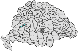
Csanád was an administrative county (comitatus) of the Kingdom of Hungary. Its territory is now in western Romania and southeastern Hungary. The capital of the county was Makó.
Geography
Csanád county shared borders with the Hungarian counties Csongrád, Békés, Arad and Torontál. The river Maros (now Mureş) formed its southern border. Its area was 1715 km2 around 1910.
History
In 1920, the Treaty of Trianon assigned a small area in the southeast of the county (Nădlac and Şeitin) to Romania. The rest of the county was united with parts of Torontál county (a small area south of Szeged) and Arad county (a small area south of Békéscsaba) to form the new county of Csanád-Arad-Torontál.
After World War II, Csanád-Arad-Torontál county was divided between the Hungarian counties of Békés and Csongrád. The Romanian part of former Csanád county is now part of the Romanian county of Arad.
Demographics
Csanád county was one of the most densely populated counties of the Hungarian Kingdom.The Hungarians formed an ethnic majority in every district except for the district Nagylak. The main part of the Slovaks and Romanians lived in the district Nagylak, the Serbs in the district Battonya.
1900
In 1900, the county had a population of 140,007 people and was composed of the following linguistic communities:[1]
Total:
- Hungarian: 103,242 (73,8%)
- Slovak: 17,274 (12,3%)
- Romanian: 13,982 (10,0%)
- Serbian: 3,981 (2,8%)
- German: 1,182 (0,8%)
- Ruthenian: 72 (0,1%)
- Croatian: 1 (0,0%)
- Other or unknown: 273 (0,2%)
According to the census of 1900, the county was composed of the following religious communities:[2]
Total:
- Roman Catholic: 71,610 (51,3%)
- Calvinist: 25,234 (18,0%)
- Lutheran: 18,384 (13,1%)
- Greek Orthodox: 16,567 (11,8%)
- Greek Catholic: 4,520 (3,2%)
- Jewish: 3,254 (2,3%)
- Unitarian: 33 (0,0%)
- Other or unknown: 405 (0,3%)
1910
In 1910, the county had a population of 145,249 people and was composed of the following linguistic communities:[3]
Total:
- Hungarian: 108,621 (74,8%)
- Slovak: 17,133 (11,8%)
- Romanian: 14,046 (9,7%)
- Serbian: 3,967 (2,7%)
- German: 1,013 (0,7%)
- Ruthenian: 119 (0,1%)
- Croatian: 8 (0,0%)
- Other or unknown: 341 (0,2%)
According to the census of 1910, the county was composed of the following religious communities:[4]
Total:
- Roman Catholic: 76,076 (52,4%)
- Calvinist: 24,897 (17,1%)
- Lutheran: 19,095 (13,1%)
- Greek Orthodox: 16,851 (11,6%)
- Greek Catholic: 4,438 (3,1%)
- Jewish: 3,353 (2,3%)
- Unitarian: 118 (0,1%)
- Other or unknown: 421 (0,3%)
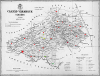
Subdivisions
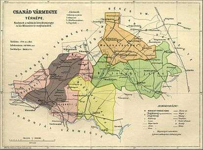
In the early 20th century, the subdivisions of Csanád county were:
| Districts (járás) | |
|---|---|
| District | Capital |
| Battonya | Battonya |
| Központ | Makó |
| Mezőkovácsháza | Mezőkovácsháza |
| Nagylak | Nagylak, (Romanian: Nădlac) |
| Urban districts (rendezett tanácsú város) | |
| Makó | |
The town of Nădlac is now in Romania; the other towns mentioned are now in Hungary.
References
- ↑ "KlimoTheca :: Könyvtár". Kt.lib.pte.hu. Retrieved 2012-06-25.
- ↑ "KlimoTheca :: Könyvtár". Kt.lib.pte.hu. Retrieved 2012-06-25.
- ↑ "KlimoTheca :: Könyvtár". Kt.lib.pte.hu. Retrieved 2012-06-25.
- ↑ "KlimoTheca :: Könyvtár". Kt.lib.pte.hu. Retrieved 2012-06-25.
