Crossett, Arkansas
| Crossett, Arkansas | |
|---|---|
| City | |
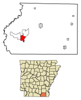 Location of Crossett in Ashley County, Arkansas. | |
| Coordinates: 33°7′29″N 91°57′48″W / 33.12472°N 91.96333°WCoordinates: 33°7′29″N 91°57′48″W / 33.12472°N 91.96333°W | |
| Country | United States |
| State | Arkansas |
| County | Ashley |
| Area[1] | |
| • Total | 5.96 sq mi (15.44 km2) |
| • Land | 5.79 sq mi (15.00 km2) |
| • Water | 0.17 sq mi (0.43 km2) |
| Elevation | 164 ft (50 m) |
| Population (2010) | |
| • Total | 5,507 |
| • Estimate (2017)[2] | 4,988 |
| • Density | 861.19/sq mi (332.48/km2) |
| Time zone | UTC-6 (Central (CST)) |
| • Summer (DST) | UTC-5 (CDT) |
| ZIP code | 71635 |
| Area code(s) | 870 |
| FIPS code | 05-16240 |
| GNIS feature ID | 0057612 |
Crossett is the largest city in Ashley County, Arkansas, United States, with a population of 5,507, according to 2010 Census Bureau estimates. Combined with North Crossett and West Crossett, the population is 10,752. Crossett was incorporated in 1903.
There are four properties on Main Street in Crossett listed on the National Register of Historic Places, as well as the Crossett Experimental Forest, located 7 mi (11 km) south.
Geography
According to the United States Census Bureau, the city has a total area of 6.0 square miles (16 km2), of which 5.8 square miles (15 km2) is land and 0.2 square miles (0.52 km2) (2.83%) is water.
Demographics
| Historical population | |||
|---|---|---|---|
| Census | Pop. | %± | |
| 1910 | 2,038 | — | |
| 1920 | 2,707 | 32.8% | |
| 1930 | 2,811 | 3.8% | |
| 1940 | 4,891 | 74.0% | |
| 1950 | 4,619 | −5.6% | |
| 1960 | 5,370 | 16.3% | |
| 1970 | 6,191 | 15.3% | |
| 1980 | 6,706 | 8.3% | |
| 1990 | 6,282 | −6.3% | |
| 2000 | 6,097 | −2.9% | |
| 2010 | 5,507 | −9.7% | |
| Est. 2017 | 4,988 | [2] | −9.4% |
| U.S. Decennial Census[3] 2014 Estimate[4] | |||
As of the census[5] of 2000, there were 6,097 people, 2,418 households, and 1,745 families residing in the city. The population density was 1,045.2 people per square mile (403.8/km²). There were 2,663 housing units at an average density of 456.5 per square mile (176.4/km²). The racial makeup of the city was 59.50% White, 39.02% Black or African American, 0.07% Native American, 0.46% Asian, 0.02% Pacific Islander, 0.30% from other races, and 0.64% from two or more races. 1.10% of the population were Hispanic or Latino of any race.
There were 2,418 households out of which 31.9% had children under the age of 18 living with them, 52.4% were married couples living together, 16.3% had a female householder with no husband present, and 27.8% were non-families. 25.6% of all households were made up of individuals and 12.8% had someone living alone who was 65 years of age or older. The average household size was 2.48 and the average family size was 2.96.
In the city, the population was spread out with 26.5% under the age of 18, 7.8% from 18 to 24, 25.4% from 25 to 44, 24.1% from 45 to 64, and 16.2% who were 65 years of age or older. The median age was 38 years. For every 100 females, there were 87.4 males. For every 100 females age 18 and over, there were 82.9 males.
The median income for a household in the city was $31,193 in 2015.[6] Males had a median income of $43,698 versus $32,149 for females. The per capita income for the city was $18,288. About 13.7% of families and 16.8% of the population were below the poverty line, including 29.1% of those under age 18 and 12.0% of those age 65 or over.
Economy
A major employer in the town is the Georgia-Pacific paper mill. Toxic waste from the plant includes carcinogens and other chemicals that have polluted local waterways and allegedly harmed the heath of residents.[7] A documentary film ("Company Town,") on the paper mill and the environment in Crossett was released in September 2017.[8]
Notable people

- James D. Johnson, Democratic gubernatorial nominee in 1966; former Chief Justice of the Arkansas Supreme Court
- Gretha Boston, actress
- K. T. Oslin, country singer and songwriter
- Barry Switzer, football player and coach
- Rylan Reed, All-American Offensive Tackle at Texas Tech. Also performed as a right-handed pitcher for the Chicago White Sox
- Jeremy Evans, Basketball player for BC Khimki
- Jessie Clark, Football player for the Green Bay Packers
- Keith Kidd, American football player. Bryant Nelson, professional baseball player
Climate
The climate in this area is characterized by hot, humid summers and generally mild to cool winters. According to the Köppen Climate Classification system, Crossett has a humid subtropical climate, abbreviated "Cfa" on climate maps.[9]
References
- ↑ "2017 U.S. Gazetteer Files". United States Census Bureau. Retrieved Aug 22, 2018.
- 1 2 "Population and Housing Unit Estimates". Retrieved March 24, 2018.
- ↑ "Census of Population and Housing". Census.gov. Archived from the original on May 12, 2015. Retrieved June 4, 2015.
- ↑ "Annual Estimates of the Resident Population for Incorporated Places: April 1, 2010 to July 1, 2014". Retrieved June 4, 2015.
- ↑ "American FactFinder". United States Census Bureau. Archived from the original on September 11, 2013. Retrieved 2008-01-31.
- ↑ "Crossett, AR". Data USA. Retrieved 12 September 2017.
- ↑ "How an Arkansas town's prosperity is, allegedly, making its people sick". Newsweek. 12 April 2016. Retrieved 12 September 2017.
- ↑ Kenigsberg, Ben (7 September 2017). "Review: All Is Not Well in 'Company Town'". The New York Times. Retrieved 12 September 2017.
- ↑ Climate Summary for Crossett, Arkansas
Municipalities and communities of Ashley County, Arkansas, United States | ||
|---|---|---|
| Cities |  | |
| Town | ||
| CDPs | ||
| Unincorporated communities |
| |